OilTrails v2.2.017
Ash Point Software


About this app
Developer Description
Oil and Gas Well Locator - Oilfield Navigation, Well Data, and Weather
Find oil and gas locations across the US with ease. Get turn-by-turn directions, view well data, weather forecasts, drop pins to see location name, and share well info and location coordinates with OilTrails. The only app that combines all these features with a simple yet powerful interface.
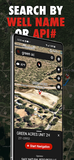
This multifunctional lease locator app makes getting to work in the oilfield a breeze. Simply enter the legal land description, name, or API number to view the surface location OR drop a pin on the map to view location and well info (if vertical). The location can be opened in Apple or Google maps for turn by turn navigation. Change the origin location to see step-by-step directions to location from the nearest town, useful for putting together ERPs or providing visitors directions.
No cell service? No problem. As long as turn by turn navigation is started before service is lost, the directions will continue to function so you don't have to worry about being stranded halfway to location.
Enter a location and view well information such as the operating company, depth, drill date, current status, downhole fluid, formation, and more. Data varies depending on the region.
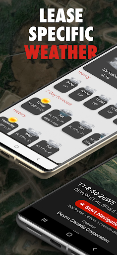
See the current, future AND past weather specific to the location entered. Wondering if the lease is too wet or has snow to be cleared? View the precipitation the location was forecasted to receive in the past three days. Scroll for 48 hrs of hourly forecasts, 7 daily forecasts, and previous forecasts.
Drop a pin on the map to see the location and well info for that location.
View history of past locations viewed and date they were looked up. Makes driving logs and reports a breeze by knowing where and when you were. Create an account to save and sync locations between devices.
Maps can be shown in a variety of ways including Topographical, 3D Satellite, 2D Satellite, Dark Roads, and Light Roads.
Take GeoPics, geographical and date/time stamped photos that you can save to your device or share.
-Turn by turn GPS navigation in Google Maps
-Enter downhole location to view well info such as the operating company, depth, drill date, current status, -downhole fluid
-View the current weather at location as well as hourly and daily forecast AND previous forecasts to see if the location has received rain/snow is the past three days
-See location in app and view with standard, hybrid, or 3D satellite imagery
-Store history of previously viewed wells/locations
-Share location and well info via message
-Drop pins on the map to see that location's LSD and well info
-International support, find wells in the United States and Australia
What's New
- Minor performance improvements and stability fixes
In-app purchases
$2.49 - $184.99 per item
Version Information
- Version
- 2.2.017
- Downloads
- 10K+
- Updated on
- Oct 6, 2025
- Released
- Feb 19, 2020
- Requires
- Android 9
Statistics
Google Play Rating History
Rating Distribution
Downloads Over Time
OilTrails has been downloaded times. Over the past 30 days, it averaged downloads per day.
Shaded area shows 30-day prediction based on historical trends
Historical data collection started recently. More data points will be available over time.
OilTrails - Google Play Rankings
Top Rankings
| Rank | Country | Category | List | Change |
|---|---|---|---|---|
| — |
Ranking History in
No ranking data available yet. Rankings are updated daily.
#21 in Top Grossing Maps And Navigation in Canada


OilTrails users say on Google Play
 Gord Miskiw
Hello, Can you send me info on how to get Oiltrails app working on my new phone. Everything got transferred and synced, but Oiltrails will not work
 Covert op
great app! I use this daily to find well I need to get to. only beef I'd have is the maps could use an update
 Pyro Nemesis
When I first got this app it was great and flawless. Since the change, I've had a lot of crashes and navigation takes me somewhere completely different halfway through my drive. I probably won't renew my subscription with these issues as I can't keep checking if the destination is correct while driving.
 A Google user
I get more from other apps without any cost then I get from this app with an annual subscription. The app glitches out it doesn't take me to Google maps. without a built-in map this app makes no sense why would I pay $20 a year for something that takes me to Google.
ApkTrusted Ratings & Reviews
More from Ash Point Software
See more apps
Similar Apps

KOA Camping | RV, Cabin & Tent
Free

Regrid Property App
Free

BaseMap: Hunting Maps and GPS
Free

COMPTIA EXAM PREP 2026
Free

Shaka Guide | GPS Audio Tours
Free
DealMachine for Real Estate
Free

Placer County Sheriff
Free

Aescape
Free

Clubworx
Free

Aya Healthcare Job Search
Free

Whip Around - DVIR
Free
National Park Service
Free
Trailforks
Free

MyWWP®
Free

Hipcamp: Camping, RVs & Cabins
Free

sleepme: Path To Better Sleep
Free
Scan this QR code to download

Forwarding you to the page at Google Play market in seconds...
Open Google Play market now