
Avare vVARY
Apps For Aviators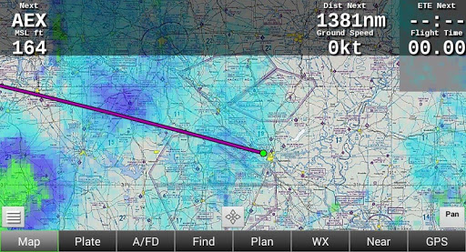


About this app
Developer Description
Aviation U.S. FAA materials + non-current TPC & ONC charts for Canada & more.
** Aviation U.S. FAA materials and more. **
** No support in Reviews. **
** Please use our Friendly, helpful Support Forum. **
24/7 at: https://groups.google.com/forum/#!forum/apps4av-forum
**NOTE: Avare can't function fully until you turn on BOTH
of Avare's requested Permissions (Location & Storage).
Avare (pronounced "ah vAir" - like "aware" with a "v") is a free moving-map Aviation GPS & EFB app.
*Note: Internet access is required only for installing the free app, aviation Database, and at least 1 of the free charts; and for any updates. We recommend that you TURN OFF Play Store AUTOMATIC UPDATE for Avare, manually update it and all Downloads, then fly in Airplane Mode to save battery.
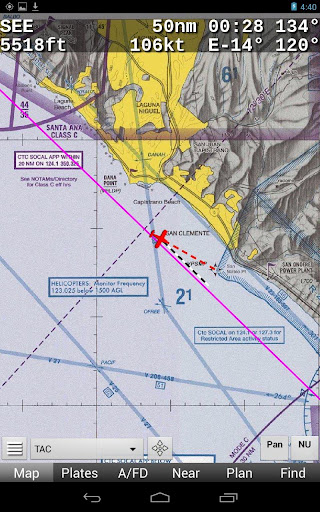
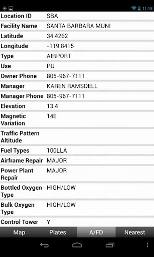
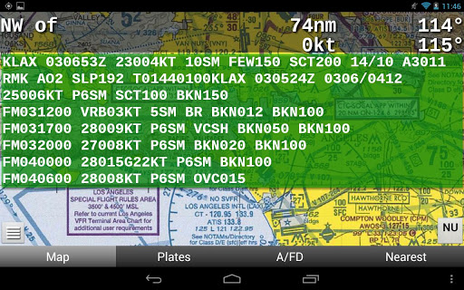
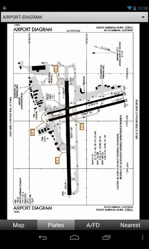
Avare offers offline moving map on all FAA charts (VFR Sectional, IFR lo/hi enroute, Approach Plate, WAC & TAC); plus A/FD info, Airport Diagrams w/GPS Taxi, and Terminal Procedures. Also: GPS status, Terrain/Elevation Maps, 50 Nearest airports, Obstacles, and more. Some FAA Charts cover Puerto Rico, plus parts of Canada, Mexico and the Caribbean. All of this is Completely Free with no ads.
*Note: Like all apps for portable devices, Avare is not FAA certified for primary navigation but may be used as outlined in FAA documents. See our NOTICE below, and the FAQ on our website for links to FAA documents.
Avare Advantages:
•Made by & for pilots
•Easy to learn & use
•Quick & responsive
•All free FAA materials & more
•Runs on most Android devices
•No ads or invasive permissions
More Features:
•Type in any address or coordinates.
•NOTAMS, METAR, TAF and Winds (Internet fetch or ADSB).
•ADSB TIS-B Traffic (UAT/1090), PIREP (free AddOn apps).
•Graphic & text TFRs (Internet fetch or ADSB).
•Canada topo, plus terrain maps for most of the world.
•External GPS, autopilot and flite sim options.
•Obstacles: Any over 500' AGL within 200' of GPS altitude.
•Frequencies, runways, fuel availability, & all A/FD info.
•13000+ GeoReferenced approach plates and taxi diagrams.
•Landscape/Portrait, North Up/Track Up (NU/TU) display.
•Draw notes on-screen, or Pan freely on charts (Draw/Pan).
•Long-Press any two points for approximate distance.
•Location icon Center, or track from your own placement.
•GPS compass direction, Bearing, and Distance to and FROM any point on the map by long-pressing one finger on that point. Great for your ATC and CTAF radio calls.
Avare installation begins with the small app, and then fetching an aviation Database and at least one chart. You can of course choose additional charts and materials for Avare to Download free at any time.
Note: The FAA occasionally changes their charts such that outdated charts may incorrectly display your location in Avare, so be sure to Update any charts you may use in flight! ANY time you plan to Update a chart, first ensure that you have the latest version of Avare and its Database.
After installing Avare, please use the Help feature to begin. New features are being added very quickly in response to user feedback, and may not be reflected in this Description page. You are invited to Contact us directly via our apps4av google group Forum to share your questions, feedback, and feature requests.
Launch Note: To access Help in the Avare app, on the Map screen tap the round Menu button, then the rectangular Help button at lower-left.
NOTICE: This software is provided "as is" and any express or implied warranties, including, but not limited to, implied warranties of merchantability and fitness for a particular purpose are disclaimed. In no event shall the copyright holder or contributors be liable for any direct, indirect, incidental, special, exemplary, or consequential damages (including, but not limited to loss of use or data) however caused and on any theory of liability, whether in contract, strict liability, or tort (including negligence or otherwise) arising in any way out of the use of this software, even if advised of the possibility of such damage.
Version Information
- Version
- -
- Downloads
- 100K+
- Updated on
- -
- Released
- Sep 10, 2012
- Requires
- Android Varies with device
Statistics
Google Play Rating History
Rating Distribution
Downloads Over Time
Avare has been downloaded times. Over the past 30 days, it averaged downloads per day.
Shaded area shows 30-day prediction based on historical trends
Historical data collection started recently. More data points will be available over time.
Avare users say on Google Play
 GospelProclaimer Missionary
Great app, I would like it if had a possibility to use foreign charts (like pdf format), even if they had to be manually geotagged. Another detail is that I can't usually get very good info from the weather section and I would like to see a winds aloft reference that would work, also some more about cloud layers. But again, great app! After all if it got too much better it might start drawing flak from the big money company(s)!
 Brian Demmler
I wish it were available for iPad. I actually use Avare almost exclusively. The caveat being I'm not a professional and my needs are very simple. I can foresee needing more in the future. 90% of this app is actually better (and less clumsy) than foreflight or Garmin Pilot. But a few issues and limitations might force me to change apps someday. That other 10% which IS clumsy is really distracting. In the meantime highly recommended
 Andrew S
I use this as a backup for VFR flight on my phone if I forget my iFly tablet at home. Cannot imagine anyone using it for instrument flight though. (Can't load approaches.) I prefer the original Avare UI to that of AvareX. Would recommend this efb for any student pilot in primary training who wants to save $80/year on an EFB. A far cry from iFly.
 Russ
Russ
so unfriendly. i can't figure out how to make this program work. simple task like downloading vfr sectional are complicated.
 Tony Turiano
Awful. I just want to be able to download & view charts. Completely unintuitive, hours invested and cannot even see a plate or taxi chart for a single airport.
ApkTrusted Ratings & Reviews
More from Apps For Aviators
See more apps
Similar Apps

DeRadar
Paid

VesselFinder
Free

Gaggle Paragliding, Ultralight
Free

Holland America Line Navigator
Free

Bike Route Planner
Paid

ATPL Questions
Free

Plane Finder - Flight Tracker
Free

ABAX Admin
Free

Orca: Boat GPS, Charts, Routes
Free
Windfinder Pro: Wind & Weather
Paid

Wanderz - Travel Guides
Free

Airhead ATPL
Free

Trippy Tour Guide
Free

SIGNALERT
Free

StaffTraveler
Free

TripIt: Travel Planner
Free
Scan this QR code to download

Forwarding you to the page at Google Play market in seconds...
Open Google Play market now