
GPS Camera: Geotag Photos, Map vVARY
PinShot Apps.


About this app
Developer Description
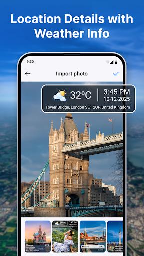
Capture photos & videos with live GPS location, map, date & time stamps.
Whether you’re traveling, documenting fieldwork, visiting client sites, or simply keeping location-based records, this app makes every photo more meaningful and trustworthy.
🌍 Key Features
📍 Live Location
- Set your current location or choose any place manually on the map.
- Instantly view accurate place details while capturing photos.
📸 Capture Photos & Videos
- Take photos and videos with automatic location, map, date, and time stamps.
- Choose from multiple professional stamp templates and card styles.
🗂️ My Library
- All your GPS-tagged photos and videos are safely stored in one place.
- Quickly access, view, or share your stamped media anytime.
🖼️ Import & Stamp
- Import existing photos from your gallery.
- Add custom location stamps, map stamps, date/time, and weather details.
🗺️ Location-wise Images
- Easily browse photos grouped by location.
- Review your travel memories based on where they were captured.
🎛️ Customization Options
- Change map type (Normal, Satellite, Terrain, Hybrid)
- Change date & time
- Set date/time formats
- Choose Celsius or Fahrenheit for temperature
- Select from multiple stamp templates & styles
🔒 Permissions Used
- Camera: Capture photos & videos
- Location: Add GPS coordinates, address, and map details
- Storage / Media: Access and display your media files stored on the device.
- Record Audio: Needed for video recording
- Notifications: Notify users about saved media or updates
GPS Map Camera: With Location is the ultimate tool for travelers, photographers, surveyors, delivery staff, field workers, and anyone who needs proof of location with visual evidence.
Capture the moment. Keep the details. Relive your memories with accuracy.
In-app purchases
$2.99 - $39.99 per item
Version Information
- Version
- -
- Downloads
- 10K+
- Updated on
- -
- Released
- Dec 13, 2025
- Requires
- Android Varies with device
Statistics
Google Play Rating History
Rating Distribution
Downloads Over Time
GPS Camera: Geotag Photos, Map has been downloaded times. Over the past 30 days, it averaged downloads per day.
Shaded area shows 30-day prediction based on historical trends
Historical data collection started recently. More data points will be available over time.
GPS Camera: Geotag Photos, Map - Google Play Rankings
Top Rankings
| Rank | Country | Category | List | Change |
|---|---|---|---|---|
| — |
Ranking History in
No ranking data available yet. Rankings are updated daily.
#62 in Top Free Photography in Vietnam
 Beauty Scanner - Face Analyzer
GPS Camera: Geotag Photos, Map
Beauty Scanner - Face Analyzer
GPS Camera: Geotag Photos, Map
 Photo Collage Maker - FunPic
ApkTrusted Ratings & Reviews
More from PinShot Apps.
See more apps

Scan this QR code to download

Forwarding you to the page at Google Play market in seconds...
Open Google Play market now