中山道六十九次 vVARY
GROUND-BASE INC.


About this app
Developer Description
"Nakasendo 69th" This is a route map application for the old road.
Musashi Province (Tokyo, Saitama Prefecture)
Kozuke (Gunma Prefecture)
Shinano Province (Nagano Prefecture)
Mino Province (Gifu Prefecture)
Passing through Omi Province (Shiga Prefecture)
69th to Kyoto,
There are 129 ri, 10 towns and 8 kens (about 505 km).
You can trace and walk without hesitation using GPS. You can also enjoy it by bicycle. (The pass is impossible)
On the map, I pointed out "post stations," "Ichirizuka," "famous places," etc.
Also, Keisai Eisen and Hiroshige Utagawa collaboration,
I also pointed out the current location depicted in the Ukiyo-e "Kiso Kaido 69ji".
Now, launch the app and go on a highway walk !!
This app points from Edo Nihonbashi to Kyoto Sanjo Ohashi.
This application is a "shared growth application".
The highway is alive. Information will be updated from time to time as continuous updates.
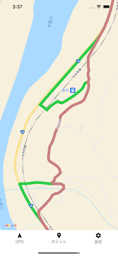
■ Display
○ Route
The old road is shown in red.
Currently, the place where the old road has disappeared is displayed in "green" as a detour, but
Small detours due to being cut off by highways or railroad tracks are regular routes.
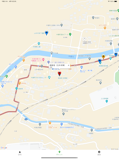
○ Post stations / famous places, etc.
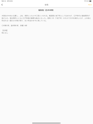
The post station points to the "honjin".
The information is "Gokaido Minute Encyclopedia" completed in the third year of culture (1806).
It is based on the information in the "Yadomura Daishocho" that was investigated by Tenpo during the Ansei era (1840-50s).
Since it is viewed from the perspective of the end of the Edo period, it does not cover famous places after the Meiji era.
In addition, the names of the entrances and exits vary depending on the post station, such as "Mitsuke," "Kido," and "Stick Nose."
In this application, it is unified to "Edo" and "Kyo".
○ Ichirizuka
Those whose whereabouts are unknown are pointed out as "guesses".
○ Ukiyo-e points
There are various interpretations, so not all are specific.
■ Main functions
○ GPS button
You can turn on / off the GPS function on the map.
○ Point button
You can show / hide all points on the map.
○ Setting button
Displays application details, usage, advice, etc.
Version Information
- Version
- -
- Downloads
- 10+
- Updated on
- -
- Released
- Jan 16, 2026
- Requires
- Android Varies with device
Statistics
Google Play Rating History
Rating Distribution
Downloads Over Time
中山道六十九次 has been downloaded times. Over the past 30 days, it averaged downloads per day.
Shaded area shows 30-day prediction based on historical trends
Historical data collection started recently. More data points will be available over time.
ApkTrusted Ratings & Reviews
More from GROUND-BASE INC.
See more apps
Scan this QR code to download

Forwarding you to the page at Google Play market in seconds...
Open Google Play market now