
NavKid Nautical Maps Europe vVARY
MarinePlan NL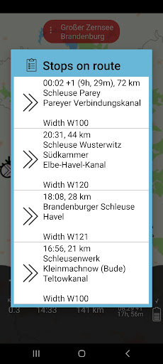


About this app
Developer Description
NavKid boat route planner + nautical charts of Europe
NavKid is free, but the map has an optional annual subscription. You have 7 days to try all the features for free, after which you can choose to continue with a reduced set of features for free, or start the annual subscription, which means you make the payment via Google Play (you pay to Google). This subscription is EUR 19.50 per year. The subscription never starts automatically and you don't need to cancel, after a week the application reverts to a reduce feature set that is for free. You can decide yourself whether to start an annual subscription. You can cancel a subscription anytime by selecting Subscription Management, then Manage/cancel Subscription in the settings menu.
The NavKid Android App for boat navigation is equipped with the latest MarinePlan water charts of the major parts of Western Europe and has a built-in, very extensive route planner. The app does not need an internet connection to navigate. For map updates, an internet connection (such as WIFI) is required. The App can therefore run on a simple and cheap tablet on board without the need for internet (except for map updates).
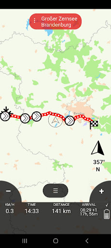
NavKid is known for the very simple and well-arranged operation and interaction with the map. The route planner is very comprehensive and navigates from harbour to jetty, specifying the arrival time and distance. Bridges and locks are clearly visible.
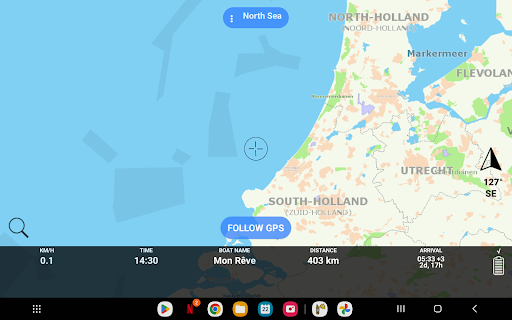
The water map has all the details. All ditches, lakes, canals and ports are indicated. The water map can be displayed in different styles (such as ANWB, Google Maps, TomTom, OpenStreetmap, Navionics, Vaarkaart, augmented satellite image).
You can specify the dimensions and characteristics of your boat so that the chance of surprises is minimized. One-way traffic, special permits, areas with a Small Boat License II, areas outside the Inland Waterways Police Regulations (BPR in the Netherlands) are all indicated.
The names on the map can be displayed in different languages (including English, Dutch, Frisian, Italian, French, Greek, Spanish, Polish). Almost all canals and lakes have a name so that you know the name of the water where you are sailing. This is always in the picture.
The quick search function finds ports, places, lakes, ditches, bridges, locks, shops, gas pumps and the like.
Keep an eye on the website http://www.marineplan.com; we publish the latest features and status there.
If you have questions you can call or email; we try to help everyone quickly. Check the rating of the NavKid app; this is the highest of all; the reviews speak volumes. Our support is strong and we are quick with updates in case of problems.
You can indicate in the app if something is wrong or missing on the map. Then it comes directly to the cartographer and we usually have a new map update ready for free within a day.
Nice feature is "friends on the map". You can now share your location and see friends who do the same on the map, or get notified when they are nearby or arriving soon. This can also be used as a warning for less welcome boats.
If you have a large screen with, for example, Chromecast, you can display the app on it (if your tablet or telephone allows this). This is ideal to follow a ship on the map; the card then moves along with the ship.
For GDPR compliance we refer to http://marineplan.com/2023/04/22/deleting-your-data-for-your-privacy/
________________________
We use the icons from https://icons8.com/
In-app purchases
$21.99 per item
Version Information
- Version
- -
- Downloads
- 10K+
- Updated on
- -
- Released
- Jun 3, 2020
- Requires
- Android Varies with device
Statistics
Google Play Rating History
Rating Distribution
Downloads Over Time
NavKid Nautical Maps Europe has been downloaded times. Over the past 30 days, it averaged downloads per day.
Shaded area shows 30-day prediction based on historical trends
Historical data collection started recently. More data points will be available over time.
NavKid Nautical Maps Europe users say on Google Play
 A Google user
Een top app voor als je aan het varen bent! Ik heb hem van de week nog gebruikt en alle details die ik nodig had stonden in de app. Zoals informatie over de bruggen (een nummer is altijd handig) of hoeveel diesel mijn boot ongeveer gaat verbruiken voor de trip. Ik raad de app aan voor alle personen die het leuk vinden om te varen!
A Google user
Really bad start...It won't let me start the "free" trial without first paying. Not sure if that is what was intended.?? Pity. I was looking forward to it and quite prepared to pay if I thought it was any good - AFTER the trial. Samsung TAB 3 Tablet NB. The developers very promptly made it possible for a 7 day free trial. In speaking with them personally, they were also very helpful! Now to try the app itself. A promising response...
ApkTrusted Ratings & Reviews
Scan this QR code to download

Forwarding you to the page at Google Play market in seconds...
Open Google Play market now