Altura del rio v1.151
mastra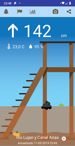


About this app
Developer Description
Real-time river level in the Paraná Delta in Tigre and Rio de la Plata
TIDE STATIONS 📏:
- In Rio Lujan and Canal Arias very close to Villa la Ñata and Dique Lujan
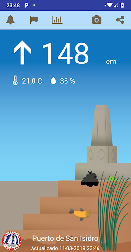
- In the Port of San Isidro
REPORTS HEIGHT OF THE RIO DE LA PLATA:
- Delta first section
- San Isidro
- San Fernando
- Buenos Aires
- La Plata
- and Pilote Norden
WIDGET: You can see the height of the river for the initial screen
WIND ⛵️💨🌬 the wind in real time at Sunset Point, Club Avellaneda in San Isidro, Windguru station in San Isidro, La Plata and Pilote NORDEN.
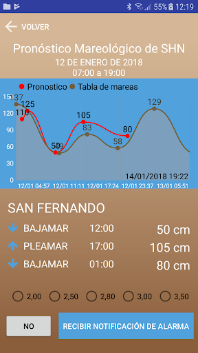
SHN Naval Hydrography Service Tidal Forecast
Alert and notification 🌊🔥 when the Pleamar forecast exceeds a certain level.
Alert and notification by river level live
GRAPHICS 📈📉
- Historical river height for 24 hours
- Historical Forecast and tide
NEW:
Tide Table in San Fernando
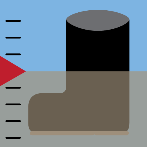
The measurement is made with our digital tide gauge located near the confluence of Rio Lujan and Canal Arias and the level is shown in centimeters using the same reference as the prefecture hydrometer of Dique Lujan.
Current TEMPERATURE AND HUMIDITY in the Delta.
An arrow 🔝 indicates the upward or downward trend.
Fish 🐟 and plants 🍀 move with the current of the river. If you go left the river goes down and to the right it rises.
PHOTOS 📷 with the information superimposed to share
Set an alert level to receive a notification on your phone when the river exceeds that level
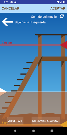
Adapt the water level shown to the actual spring
Change the direction of the spring and / or change the direction of the current.
Share the image of the dock and the current data!
By knowing the height of the real river and live you can know:
- If there is water in the park of the house or if it covers the dock
- If it is possible to enter the canal due to lack of water
- You cannot leave the marina due to lack of water
- Are the streets of Tigre and Rincon de Milberg beginning to flood?
- Good bite to fish? 🦈
- Is it nice to row? 🛶🚣♂️
- Can you navigate outside the canal? ⛵️
PROBLEMS, DOUBTS? We respond at buglandapp@gmail.com for any opinion, suggestion or error!
User manual: https://www.alturadelrio.com/manual
Instagram: https://www.instagram.com/alturadelrio/
What's New
In-app purchases
$0.99 - $23.99 per item
Version Information
- Version
- 1.151
- Downloads
- 10K+
- Updated on
- Oct 7, 2025
- Released
- Nov 16, 2015
- Requires
- Android 6.0
Statistics
Google Play Rating History
Rating Distribution
Downloads Over Time
Altura del rio has been downloaded times. Over the past 30 days, it averaged downloads per day.
Shaded area shows 30-day prediction based on historical trends
Historical data collection started recently. More data points will be available over time.
Altura del rio - Google Play Rankings
Top Rankings
| Rank | Country | Category | List | Change |
|---|---|---|---|---|
| — |
Ranking History in
No ranking data available yet. Rankings are updated daily.
#8 in Top Grossing Weather in Argentina

Altura del rio users say on Google Play
 Cosme Argerich
La App es muy básica, pero es útil y rápidamente se comprende el estado y tendencia de la marea. Utiliza una referencia gráfica (altura del agua expresada en los escalones de un muelle) tal como se usa en el Delta. No sé si tiene sentido hacerla mas compleja. Me suscribí a la versión paga 1 U$ BNA x mes y ahora puedo customizar algunas funciones.
 Alberto Michelis
olivos para cuando?
 A Google user
Buena app lástima la cantidad de limitaciones en versión gratuita y el precio de la versión paga no se justifica
A Google user
Horrible. Muy pobre, gratis es cara
ApkTrusted Ratings & Reviews
Scan this QR code to download

Forwarding you to the page at Google Play market in seconds...
Open Google Play market now