
Paragliding Map v11.9.0
Paragliding Map


About this app
Developer Description
See where you can fly right now. Worldwide!
The most comprehensive source for site info, forecasts, webcams, photos & more!
See where you can fly right now. Worldwide!
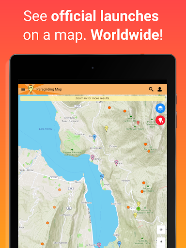
▪ Explore over 15,000 launch sites, 7,500 landings, 30,000 weather stations and 39,000 webcams.
▪ Official data from the DHV, Flyland, FFVL, Paragliding Earth and more.
▪ Forecasts from Meteoblue, Windy and WindFinder.
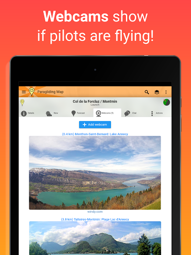
▪ Live webcams.
▪ Photos give you a great impression of each spot.
▪ Valley winds - Arrows show valley wind directions in the European Alps.
▪ Wind animation - View clouds, thunderstorms, rain and wind at different altitudes.
▪ Airspace - View airspace and NOTAMs (short notice, daily airspace restrictions) on the map.
▪ Official NOTAMs - View Notices to Airmen (NOTAMs) on the map from international aviation authorities. A vital safety feature for every flight!
▪ Automatic NOTAM warnings - A prominent warning is displayed when an active NOTAM impacts your launch or landing.
▪ Filter the map to show only launches for paragliding, hang gliding, speed flying, thermalling, soaring, hike & fly, public transport, wind speed and much more!
▪ See soaring index, cloud cover, weather warnings and much more!
▪ Many forecast providers: UK MetOffice, German Weather Service, Meteo France, meteoblue, ECMWF, NOAA and others!
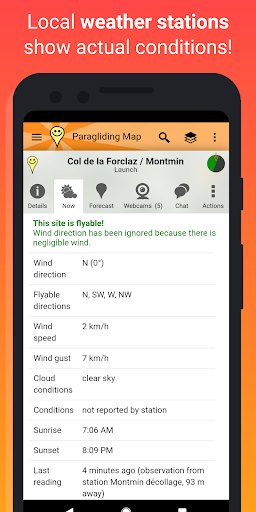
▪ Real-time weather station data from Pioupiou, Holfuy, MADIS and FFVL show you actual weather conditions.
▪ 3D view.
▪ "Hike & fly" trails.
▪ Ski lifts, cable cars and gondolas.
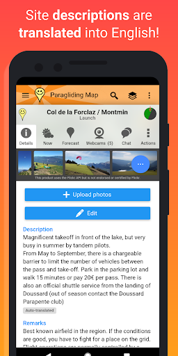
▪ Automatic translation of site descriptions into English.
▪ See future flying conditions on the map by using the Time Travel Slider.
▪ Directions to each spot using navigation.
▪ Favourites can be saved for easy access later.
▪ Advanced search.
▪ Send “SOS!” and “I need a ride” messages to friends, including your GPS coordinates.
▪ Links to original info from the DHV, Flyland, FFVL und Paragliding Earth.
▪ No advertising.
▪ Full support included.
Your feedback is always welcome. Help us to make the best paragliding app in the world!
Many feature of Paragliding Map are free but supported by advertising. If you choose to make any in-app purchase, advertising will automatically turn off and your purchase will be enabled (webcams, forecasts, etc).
Paragliding Map is the mobile version of ParaglidingMap.com.
Privacy policy and terms and conditions can be found at https://www.paraglidingmap.com/TermsAndConditions.aspx
What's New
• Add valley winds, landing fields, parking zones, power cables, and more to the map.
• Launch details now show more info when you tap a map marker.
• Slide launch details up or down to see more or less.
• Small markers are now easier to tap.
• Bugfixes and improvements.
In-app purchases
$0.99 - $399.99 per item
Version Information
- Version
- 11.9.0
- Downloads
- 100K+
- Updated on
- Oct 28, 2025
- Released
- Nov 28, 2010
- Requires
- Android 7.0
Statistics
Google Play Rating History
Rating Distribution
Downloads Over Time
Paragliding Map has been downloaded times. Over the past 30 days, it averaged downloads per day.
Shaded area shows 30-day prediction based on historical trends
Historical data collection started recently. More data points will be available over time.
Paragliding Map - Google Play Rankings
Top Rankings
| Rank | Country | Category | List | Change |
|---|---|---|---|---|
| — |
Ranking History in
No ranking data available yet. Rankings are updated daily.
#34 in Top Grossing Sports in France


#47 in Top Grossing Sports in Germany


#61 in Top Grossing Sports in Poland


Paragliding Map users say on Google Play
 lucien simon
Craig is available and super helpful when support is needed. This is an extremely useful app , directions to launch work and everything else is pretty much correct. Obviously cross check the weather conditions on the day, flyable directions are right but true wind speeds can vary considerably. This is almost the complete guide in your pocket! Thank you Craig, you've created a fine tool here.
 Andrea Signoretto
It's a pretty cool app! I used it to discover takeoffs around my location and to evaluate the wind orientation. The flyability data need to be taken with a grain of salt, but it remains a good indication!
 A Google user
Very slow app to load and not accurate for some spots. Much greater apps exist on the market. The research functionality does not work all the time and that's a pity.
A Google user
Exceptionally annoying and long ads, impossible to copy coordinates (!!), unaid version does virtually nothing except for showing location of takeoffs (which is contributed content), some controls get covered at certain times, ui and ux like from the 90s. Gosh this sucks.
A Google user
The free version is now useless. Full screen ads every minute or so, no current location, no Google maps layer. Unfortunately a formerly good app is now completely ruined.
ApkTrusted Ratings & Reviews
Similar Apps


Scan this QR code to download

Forwarding you to the page at Google Play market in seconds...
Open Google Play market now