Coordinator-Collect Coordinate v7.9.1
DER Soft


About this app
Developer Description
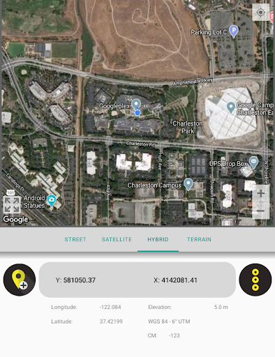
Collect GPS coordinates on the map, convert, find, calculate area, open KML.
All of the features above are free.
On the other hand if you become a Coordinator Pro subscriber, you can benefit from many extra features in addition to these features. With Coordinator Pro, subscribers can use some extra features such as Cloud Database Functions (creating points, lines & polygons, sharing your layers with teammates, working simultaneously with teammates, working offline and synchronizing, etc), exporting to KML & Excel files, making elevation & address querying and so on. It is ad-free.
Besides longitude/latitude, subscribers can find out the altitude value of a point on the map. You can search by address and so that locate it on the map and learn the GPS coordinate (longitude/latitude or northing/easting) value of this place. The address locating feature works based on maps services and it's very effective.
If you are a subscriber, you can use the Coordinator Web app. So that you can use the cloud database features of the Coordinator app on the web page on your computer and monitor the data instantly. You can view/track and edit cloud database data on the web page. In this way, you can instantly monitor the data movements made in the mobile app in the field, in the web browser on your computer.
The coordinate systems of the countries, which the app is most downloaded, are added to the app.
Current list of the countries and their coordinate systems defined in this app:
World - GPS(WGS 84)
World - WGS 84 - 6 ̊ UTM
United States - "NAD 1983 HARN State Plane Coordinate Systems(meters & feet)" and "Military Grid Reference System (MGRS)"
Algeria - "Nord Sahara 1959 / UTM 6 ̊ "
Azerbaijan - "Pulkovo 1942 / Gauss-Kruger 3 ̊ " and "Pulkovo 1942 / CS63"
Bulgaria - "Pulkovo 1942(58) GK 6 ̊ "
Germany - "DHDN/3 ̊ GK" and "ETRS89 UTM 6 ̊"
India - "Kalianpur 1975 / India" and "Kalianpur 1975 / UTM 6 ̊"
Indonesia - "Indonesia 1974 UTM 6 ̊" and "DGN 1995 Indonesia TM3 ̊"
Iran - "ED50(ED77) / UTM 6 ̊"
Iraq - "Nahrwan 1967 / UTM 6 ̊" and "ED50 / Iraq National Grid" and "Karbala 1979 / UTM 6 ̊"
Israel - "Palestine 1923/Palest. Grid" and "Palestine 1923/Israeli CS Grid" and "Israel 1993/Israeli TM Grid"
Lebanon - "Deir ez Zor / Levant Ster." and "Deir ez Zor / Syria Lambert"
Mauritania - "Mauritania 1999 / UTM 6 ̊"
Morocco - "Merchich / Nord Maroc" and "Merchich / Sud Maroc"
Netherlands - "Amersfoort / RD New" and "Amersfoort / RD Old"
Palestine - "Palestine 1923/Palest. Grid" and "Palestine 1923/Israeli CS Grid" and "Israel 1993/Israeli TM Grid"
Philippines - "Luzon 1911 / Philippines" and "PRS92 / Philippines"
Romania - "Dealul Piscului 1930 / Stereo 33" and "Pulkovo 1942(58) / Stereo 70"
Russia - "Pulkovo 1942 / Gauss-Kruger 3 ̊"
Saudi Arabia - "Ain el Abd / UTM 6 ̊" and "Ain el Abd / Aramco Lambert"
Syria - "Deir ez Zor / Levant Ster." and "Deir ez Zor / Syria Lambert"
Turkey - "ITRF 96 - 3 ̊" and "ED 50 - 3 ̊" and "ITRF 96 - 6 ̊" and "ED 50 - 6 ̊"
United Arab Emirates - "Nahrwan 1967 / UTM"
What's New
In-app purchases
$9.99 - $89.99 per item
Version Information
- Version
- 7.9.1
- Downloads
- 500K+
- Updated on
- Oct 23, 2025
- Released
- Mar 5, 2016
- Requires
- Android 7.0
Statistics
Google Play Rating History
Rating Distribution
Downloads Over Time
Coordinator-Collect Coordinate has been downloaded times. Over the past 30 days, it averaged downloads per day.
Shaded area shows 30-day prediction based on historical trends
Historical data collection started recently. More data points will be available over time.
Coordinator-Collect Coordinate users say on Google Play
 A Google user
it gives x and y coordinates and altitude(z coordinate) according to different systems and countries. For example if you have been living in Turkey, you need to choose collect coordinates then Turkey option then the system option you need (ed50 6 utm was wanted from me because i am a mine engineer), and then you can see decimal degrees and x, y coordinates easily. z is altitude from the sea level and although z symbol isn't written, you can see it as altitude.
 ben nunoo
Good app. But only x and y are recorded, the z field turns to zero
 mohamed labiad
The last version is very bad, I had to downgrade to previous version and disabled the auto update.
 Rafael Colon
it doesn't open with maps
 kometa0017
The app is asking for credit card details before it actually had been tried. Sorry developers but I don't trust that it can do the job for me accurately enough. Can't comment on the functionality as I can't try the app, as I can't progress beyond the credit card details screen.
ApkTrusted Ratings & Reviews
More from DER Soft
See more apps

Similar Apps


Scan this QR code to download

Forwarding you to the page at Google Play market in seconds...
Open Google Play market now