
DC Transit: WMATA Metro Times v3.7.0
Kapil Vasani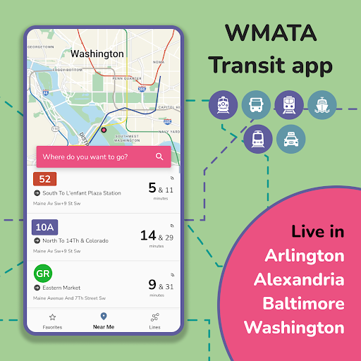


About this app
Developer Description
Real-time transit schedules & alerts for WMATA, ART, DASH and Fairfax transit
Features:
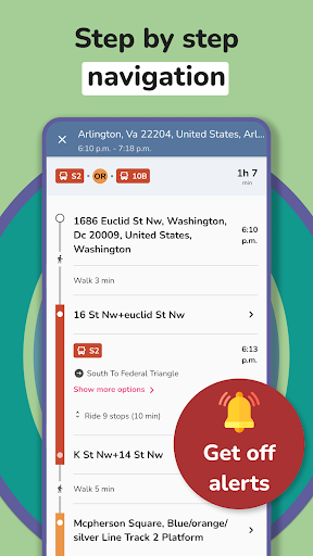
► Trip Planner available (Plan your trip around Washington DC & Baltimore. WMATA, DC Circulator, Arlington Transit (ART), DC Streetcar, PG County, Maryland Transit, Fairfax CUE and UMD Shuttle Transit supported)
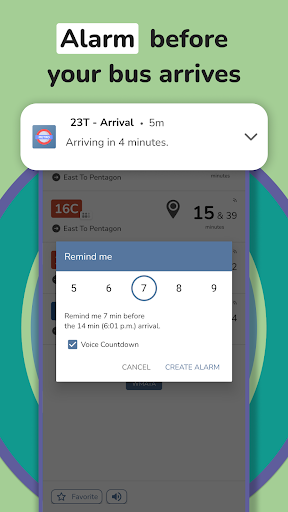
► Set an alarm for your bus and get notified before departure
► Shows current weather forecast
► Find out when your next DC Metro, bus or streetcar arrives
► Real time WMATA buses and streetcars arrival times
► Get Metro Service Alerts in app
► Save frequent stops to your favorite
► Find multiple nearby stops using your location
► Find stops using routes
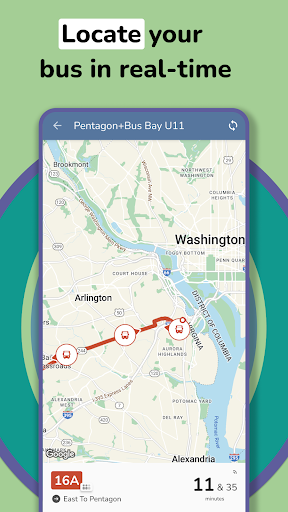
► Get real-time buses and streetcars locations on Map
► Stops list on map with route path
► Offline usability
► DC metro maps included to increase efficiency of your commute
► Pull To Refresh functionality
► Share buses & streetcars arrival times with your friends
► Not sure which WMATA stop your are standing at? See Street View of WMATA stop
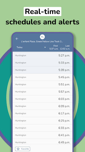
► Full scheduled arrival times available
► Get Metro Service alerts on real-time arrival screen. No need to look for what's affecting your transit service manually
► Plan your trip ahead using Trip Planner
► You will be able to plan your trip across Washington DC Area
Supported Transit:
- WMATA (DC Metro and Bus)
- Arlington Transit (ART)
- DC Circulator and DC Streetcar
- Alexandria Transit Company (DASH)
- Fairfax Connector Shuttle Transit
- Maryland MARC
- Maryland Rail
- Maryland Metro
- Maryland Transit
- Maryland Commuter Bus
- Regional Transportation Agency of Central Maryland
- Harbor Connector
- Towson University
- Towson Loop
- Loudoun County Transit
- TransIT Services of Frederick County
Plan your trip around Washington DC using metro, bus , streetcar or train.
Trip scheduler will help you to plan your station-to-station trip, help you with transfers, and provide time, distance and fare estimates for your trip.
Keep up to date with the latest wmata news, advisories and system alerts that may impact your commute.
Note: This app is in no way affiliated or endorsed by the WMATA. App uses nextbus & gtfs data.
* Foreground location permission required for an alarm feature to work.
*includes real-time info(eg bus time & subway time in WMATA, bus tracker & metro, train tracker in Washington DC, NextBus in Washington, wmata tracker, dc metro tracker, metro bus schedule, Washington metro, art metrobus)
What's New
Lets us know what do you think in comments
In-app purchases
$1.49 - $11.99 per item
Version Information
- Version
- 3.7.0
- Downloads
- 50K+
- Updated on
- Nov 27, 2025
- Released
- May 7, 2017
- Requires
- Android 7.0
Statistics
Google Play Rating History
Rating Distribution
Downloads Over Time
DC Transit: WMATA Metro Times has been downloaded times. Over the past 30 days, it averaged downloads per day.
Shaded area shows 30-day prediction based on historical trends
Historical data collection started recently. More data points will be available over time.
DC Transit: WMATA Metro Times users say on Google Play
 Key Martin
I was using MetroHero but they have shut down. I'm still navigating through the Transit app, but while it doesn't seem to be as customizable as MetroHero, it is more than sufficient. Definitely works as a substitute.
 E H
E H
The integrated public transit itinerary builder is far easier to use than the WMATA website trip planner. sometimes glitches, though.
 Carlos Torres
It doesn't show all possible connections. For instance, if I want to go from one Metro station to another using MetroRail where there is a transfer required in between (and is available based on WMATA website Trip Planner), the App just shows me the MARC option from the original station to the final station. I want the App to also show me the MetroRail route and connections in between.
 triplereef
- Build a selectable metro map - not just the google map, don't need a street map overlay. - The route finder doesn't work at all, every selection says its outside of coverage area. - 'next train' functionality is what people need - rethink it's format, e.g. why is the stop name the smallest of the three font sizes
 Doc McConnell
I use this app for bus ETAs but the data isn't accurate. It appears to only provide "predictions" based on published timetables, not the GPS data available through WMATA's website. Please update to reflect real time data!
ApkTrusted Ratings & Reviews
Scan this QR code to download

Forwarding you to the page at Google Play market in seconds...
Open Google Play market now