
US Public Lands v2025.8
Two Steps Beyond LLC
About this app
Developer Description
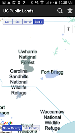
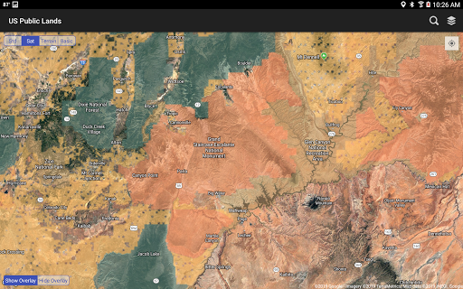
View US public land boundary maps on your device.
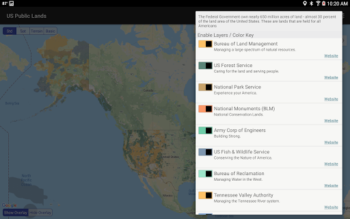
These are lands that are held for all Americans.
Up until now, there has been no quick & easy way to retrieve the boundaries of these properties without carrying physical maps, books, or slowly digging deep online.
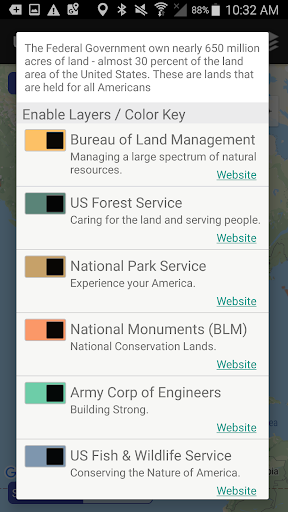
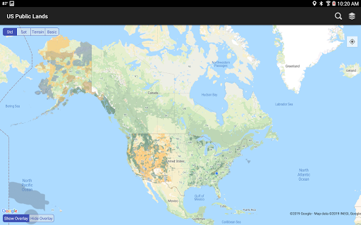
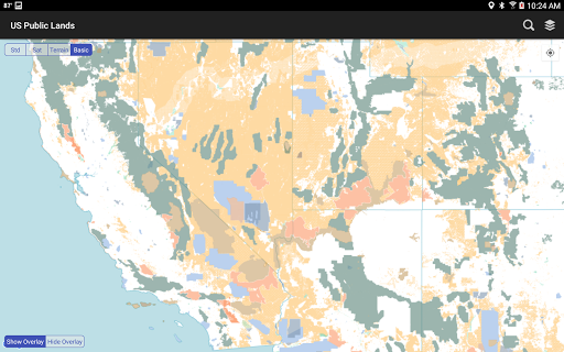
Included in this app are on device (fully works offline), individually selectable & beautifully colored layers for most of the properties administered by the federal government:
- Bureau of Land Management (BLM)
- US Forest Service (FS)
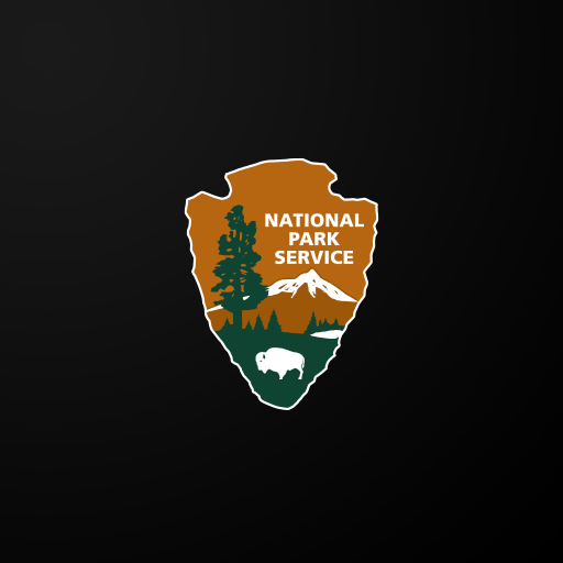
- National Park Service (NPS)
- Army Corp of Engineers (ACOE)
- US Fish & Wildlife Service
- Bureau of Reclamation
- Tennessee Valley Authority
- Department of Defense (military bases & installations)
- Other (National Laboratories, Test Sites, etc...)
Key Benefits & Features
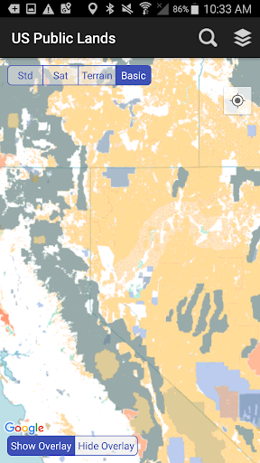
- Know which US agency owns and operates the land you're on or are heading to. Use the "Layers" icon to select which agencies you want displayed to create your own custom map. (Hint, the toggles are color coded to the color each layer is displayed in.)
- Links are provided to each agency's website within the app, so that you can further your research as to what land use rules apply for each public land type - such as permits, fees, activities allowed, and limits of stay.
- Map layers are stored on device - no internet connection required.
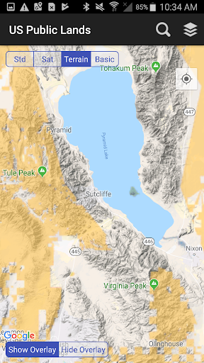
- Be sure to turn on the 'Basic' base map to see the US Public Land labels for each land area. This base map layer is also stored entirely on your device, and can be utilized if you do not have an internet connection or would like to conserve bandwidth.
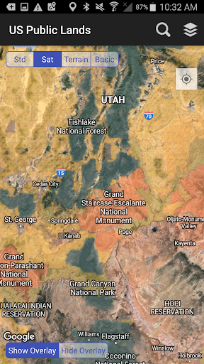
- If you have an internet connection, you can utilize standard and satellite view maps as well as the base layer underneath the public land overlays.
- A boondocker's assistant - While US Public Lands is not specifically a camp site locator and does not have a database of specific sites, by turning on the satellite view map, you can better scout out trails, roads and signs of dispersed camping locations within the boundaries of the public land resources.
- Quickly toggle between 'Show' and 'Hide' via the "Map" icon to more clearly see satellite images below.
- If you have GPS access on your device, click the 'Locate Me' icon to show your present location - know what type of land you're on right now!
- Built in search tool locates anything on device maps supports (requires internet access) - including cities, states, zip codes, addresses and points of interest. A pin is dropped at the search location.
*The maps included in this app were generated from data provided by the Protected Area Database (PAD-US) of the U.S. Geological Survey* (https://www.usgs.gov/programs/gap-analysis-project/science/pad-us-data-overview). We would like to thank them for providing the public domain raw map data that we’ve been able to utilize to create this interactive overlayable mapping & navigation tool. We will update our maps in the future to stay in sync with improvements to this data set.
Two Steps Beyond is not affiliated with, and does not represent, the USGS or any other US Government Agency.
Please note, the USGS PAD-US database contains the “most up-to-date aggregation of Federal lands and waters” available, but this database is still evolving and some locations may not be listed and others may not have precisely accurate boundaries. Resolution across the nation may vary. And always remember - there may be private unmapped inholdings within any public lands - so always pay attention to local signage, indications, and information.
The US Public Lands app should only be used as an overview, and you should always confirm more precise details by consulting local field offices, administration websites, and other resources. Do not solely rely on this app for determining if you are on public or private land.
What's New
Additional support for Dark Mode.
Version Information
- Version
- 2025.8
- Downloads
- 10K+
- Updated on
- Aug 26, 2025
- Released
- Apr 16, 2014
- Requires
- Android 5.0
Statistics
Google Play Rating History
Rating Distribution
Downloads Over Time
US Public Lands has been downloaded times. Over the past 30 days, it averaged downloads per day.
Shaded area shows 30-day prediction based on historical trends
Historical data collection started recently. More data points will be available over time.
US Public Lands - Google Play Rankings
Top Rankings
| Rank | Country | Category | List | Change |
|---|---|---|---|---|
| — |
Ranking History in
No ranking data available yet. Rankings are updated daily.
#5 in Top Paid Travel And Local in United States

#19 in Top Paid Travel And Local in Philippines


#19 in Top Paid Travel And Local in Thailand
#19 in Top Paid Travel And Local in Vietnam
US Public Lands users say on Google Play
 A Google user
This is a 'must have' app if you're a full or part-time boondocker. It's a great way to research an area and find some hidden gems that aren't in the directories. It offers numerous categories of public lands such as BLM, USNF, and some that should be avoided, like DOD. Super useful and easy to use.
A Google user
This app is a great way to see if the land where I am or I'm going has places I can camp for free. I like that it seems to work even with no cell coverage. The one thing I'd change if I could would be to choose which part of the US I'd like data files downloaded for. My phone doesn't have a huge amount of memory, and this app uses a lot, I assume for the great data file.
A Google user
Edit: the map accuracy has been improved which earns this app 3 stars instead of 2, but it won't let you create a pin or find gps coordinates of a particular location which makes it useless as a navigation tool. I'd rate 5 stars if they added that one little feature. Then I'd be able to transfer it to google maps for directions. Instead I have to memorize what the general area looks like and then go hunting for it on google maps.
A Google user
Inaccurate. Current location way off...by miles, not just a few feet. Tested app while on known BLM land. App has my location as being in the nearest town miles away (nearest cell tower, maybe??). As mentioned by other reviews, this type of flaw could cause a user to be on private property and not know it. Be diligent when using this app. Great concept, could be very useful if accuracy was improved. Would also be nice if app included camping locations on public land, state trust land...etc.
 grednav
Someone took a nation-wide screenshot of public GIS data and turned it into an app. The result is horribly pixelated. Looks great when you're zoomed out at state level. Worthless when you zoom in beyond county level and are missing the real details of public land boundaries. Geospatial MVUM maps are free, but this "app" is not.
ApkTrusted Ratings & Reviews
More from Two Steps Beyond LLC
See more apps

Similar Apps


Scan this QR code to download

Forwarding you to the page at Google Play market in seconds...
Open Google Play market now