Volcanoes & Earthquakes v2.21.4
VolcanoDiscovery


About this app
Developer Description
Earthquake tracker and volcano alerts in real time, with maps, news and stats.
volcano monitoring app. See recent earthquakes worldwide or near your location, explore active volcanoes, receive instant alerts, and follow breaking news on seismic activity, volcanic eruptions, and tsunamis.
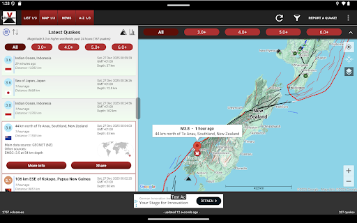
Track events as they happen using one of the most complete seismic and volcanic data collections available, sourced from over 40 national and international monitoring agencies. Filter, sort, visualize, and personalize the data the way you want: by magnitude, age, distance, region, volcano status, and more.
Features:
Earthquakes:
• Live worldwide earthquake feed (past 7 days) from 40+ data sources
• Near-real-time alerts for significant earthquakes
• Earthquake reports from users ("I felt an earthquake")
• Earthquakes near active volcanoes
• Complete earthquake archive since 2012
• Filter by magnitude, age, distance, continent, country, or state
• Sort by time or magnitude
• Detailed earthquake information including depth, location, intensities, and source
• Earthquake statistics: magnitude, depth, energy, and time charts
• Alerts for quakes that might have been felt at your location
Volcanoes:
• Global volcano map with over 1,600 active and dormant volcanoes
• Volcano status and eruption history
• Latest volcano news and volcanic ash advisories
• Full volcano directory (alphabetical, by country, or by activity level)
Maps and Data Visualization:
• Tectonic plate boundaries
• Thousands of active fault lines
• Highly compressed data for minimal bandwidth
• Multiple display and filtering options
Customization and Tools:
• Custom alerts for user-defined locations
• Adjustable font sizes
• Switch between 19 supported languages
• Export and import all app settings
• Optional automatic background updates
• Tsunami alerts and related news
• User interface customization options
Upcoming features:
• More data sources
• Expanded earthquake and volcano news
Data sources include:
USGS, EMSC, GFZ, INGV, GeoNet, NRCAN, BGS, IGN Spain, IMO Iceland, PHIVOLCS, KOERI Turkey, CEIC China, Universidad de Chile CSN, SSN Mexico, and many others.
Support us:
If you enjoy the app, please consider leaving a 5-star review. Your support helps us continue to improve the app.
Disclaimer:
Although we collect data from reputable scientific sources and strive for accuracy, we cannot guarantee completeness or uninterrupted availability. Use this app for general information only.
What's New
• Export and import of app settings
• Improved support for tablets
• Added tsunami alerts and news updates
• More UI customization options, 19 languages, adjustable fonts
In-app purchases
$0.49 - $46.99 per item
Version Information
- Version
- 2.21.4
- Downloads
- 1M+
- Updated on
- Jan 15, 2026
- Released
- Sep 30, 2015
- Requires
- Android 6.0
Statistics
Google Play Rating History
Rating Distribution
Downloads Over Time
Volcanoes & Earthquakes has been downloaded times. Over the past 30 days, it averaged downloads per day.
Shaded area shows 30-day prediction based on historical trends
Historical data collection started recently. More data points will be available over time.
Volcanoes & Earthquakes - Google Play Rankings
Top Rankings
| Rank | Country | Category | List | Change |
|---|---|---|---|---|
| — |
Ranking History in
No ranking data available yet. Rankings are updated daily.
#17 in Top Grossing Weather in Philippines

#38 in Top Grossing Weather in Saudi Arabia

#44 in Top Free Weather in Philippines

#50 in Top Grossing Weather in Italy
Volcanoes & Earthquakes users say on Google Play
 MistyAndBonnie “MistyAndBonnie”
I just bought the pro version. Please if you want to make me happy, add custom alerts to mag 1 to 9. I downloaded these cool sound effects to match. that's only reason I paid for premium. currently is 4 to 7+. Also I'd like it if it would front load the location on the notification, cus I'm wearing a smart watch, it takes a long time for the location to appear on my watch compared to the other apps. I want to quickly look at my watch and see magnitude and location at an easy glance.
 tva il
This app has a great deal of info.Took some getting used to,eg: a few of the'Settings'are confusing&it's hard to get the settings to 'take'(km/miles).Dont care for the political('GulfOfAmerica'). Wish it was an early warning system-but I don't think the science is quite there yet.😕For information purposes it's terrific.Would like to see length of earthquake times(how long the EQ lasted according to sensors - if poss?) TYVM DEVS!
 Jerad Libhart
I like the app, but it's a resource hog. I had to uninstall it because it was using six percent of my battery and there's no way to turn any of the things off without upgrading to the paid version Edit answer to reply: the notifications are either all or none. The only option you can modify is the magnitude and even set at 5.0, it was still draining six percent of the battery. Being able to select individual Volcanoes only for free is what would reduce it.
 Allen
Allen
I have used this app daily for many years. recent changes have made the app unusable as I can not find a way to set it back to how it worked in the past. I am now testing replacement apps
 Mike Larry
The reason why I give it a one start is 2. This app can help save people life, but it's plagued with adds, that will delay life saving actions and up to date data
ApkTrusted Ratings & Reviews
More from VolcanoDiscovery
See more apps
Similar Apps
Weather data & microclimate :
Free

Yr
Free

Emergency: Severe Weather App
Free
Nautide: Tides, Wind, Waves +
Free

Windmate
Paid

My Earthquake Alerts - Map
Free

Yahoo Weather: Forecast & Maps
Free

Clime: NOAA Weather Radar Live
Free
Foreca Weather & Radar
Free

Live Weather Forecast : VR
Paid

AccuWeather: Weather Radar
Free
myENV
Free
Windfinder Pro: Wind & Weather
Paid
St. Cloud Live StormTRACKER
Free

Rain Bird Resources
Free

Today Weather:Data by NOAA/NWS
Free
Scan this QR code to download

Forwarding you to the page at Google Play market in seconds...
Open Google Play market now