
EasyTrails GPS v3.2.9
Zirak


About this app
Developer Description
EasyTrails is the GPS tracker application for your Android device.
The perfect application for those who are passionate about OUTDOOR ACTIVITIES and TRAVELING, everybody who likes outdoor sports, and not only.
Are you going for a bike or motorcycle ride? Well, EasyTrails GPS will tell you how many miles you traveled, how much time you spent, how high you climbed and many other details. In real-time it will show you the course on a map, comparing it with downloaded tracks and points of interest.
Export your tracks in standard formats, so you can review them on Google Earth, SportTracks and TrailsRunner. Or simply upload them to online services like Garmin Connect, or many others.
Calculate routes and let EasyTrails guide you with turn directions. You can also let it guide you through previously recorded tracks.
It's possible to import tracks by e-mail or web browser (GPX/KML/KMZ file formats).
Load custom cartography, EasyTrails supports MBTILES format.
EasyTrails GPS is easy to use and extremaly accurate. It ensures the maximum duration of battery thanks to the possibility of recording in "StandBy" mode. However, be aware that use of GPS, even in background, will have a significant impact on battery duration.
► For more info, visit our website: www.easytrails.com
NEW FEATURES:
► Heart rate monitoring (paid)
We added the ability to connect to compatible Bluetooth heart rate monitors (such as Polar H6 and H7 devices). Heart rate can be seen in real time from the dashboard.
With the 'Heart rate monitoring' in-app purchase:
- heart rate data will be associated to GPS tracks
- saved tracks will have an extra heart rate chart
- heart rate data can be saved to Google Fit
Additionally, with the 'Colored tracks' in-app purchase, it will be possible to highlight heart rate data directly on the map screen of a recorded track.
OTHER FEATURES:
- Support for many different map types
- Support for user-loaded offline cartography (KMZ and MBTILES)
- Export tracks (single or multiple) in standard formats (GPX, KML, KMZ, CVS), with their associated waypoints, pictures and rich metadata
- Import tracks and waypoints (GPX, KML, KMZ)
- Resume recording of tracks
- Save waypoints with photos and descriptions
- Calculate routes and navigate with turn directions
- Real-time visualization of distance, speed, altitude bearing and other data
- Map Visualization in different modes: street map, satellite, hybrid, terrain
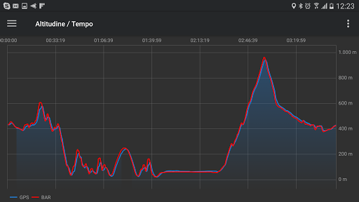
- Charts (elevation profiles, ...)
- Digital Compass
- Heart rate monitoring
- High battery duration (record in standby)
- Intuitive and User Friendly interface
- Lightweight, reliable and accurate
- Doesn't require internet connection except for displaying online cartography
What's New
NEW: improved UI on screen configurations using non-standard font sizes
FIX: some stability improvements
In-app purchases
$0.99 - $4.49 per item
Version Information
- Version
- 3.2.9
- Downloads
- 5K+
- Updated on
- Jan 4, 2025
- Released
- Dec 19, 2016
- Requires
- Android 5.0
Statistics
Google Play Rating History
Rating Distribution
Downloads Over Time
EasyTrails GPS has been downloaded times. Over the past 30 days, it averaged downloads per day.
Shaded area shows 30-day prediction based on historical trends
Historical data collection started recently. More data points will be available over time.
EasyTrails GPS - Google Play Rankings
Top Rankings
| Rank | Country | Category | List | Change |
|---|---|---|---|---|
| — |
Ranking History in
No ranking data available yet. Rankings are updated daily.
#3 in Top Paid Sports in Italy
 Ski Tracks
EasyTrails GPS
Ski Tracks
EasyTrails GPS
#51 in Top Paid Sports in Turkey


#51 in Top Paid Sports in Egypt
#52 in Top Paid Sports in Pakistan
EasyTrails GPS users say on Google Play
 A Google user
Hi. I now have a new phone and a paid for app. I found sign in but it wont let me. Help
A Google user
Great app for those who want to track their surveys, I hope you can add elevations during export on csv by then i would recommend this to surveyors/geo taggers, if elevation will be included on csv.
 Greg Conquest - gc
I have the paid versions of EasyTrails on both iOS and Android. 1) The iOS version can share multiple, discrete tracks; the android version cannot (it always exports one track no matter how many you select.) 2) The iOS version lets me decrease the logged points by time or distance (filtering). This feature is entirely missing in the android version. 3) Both versions add a sequential number at the beginning of exported tracks. I have to manually delete it every time. ... As much as I like the iOS version, I'm now looking for a replacement on android.
 Roger Rittenhouse
Too complex. No way to change the data display. I wanted to remove some of the data points. Have no need for some
 Brandi Poteat
Was not user friendly
ApkTrusted Ratings & Reviews
Scan this QR code to download

Forwarding you to the page at Google Play market in seconds...
Open Google Play market now