
FLY is FUN Aviation Navigation v35.34
Petr Kouřil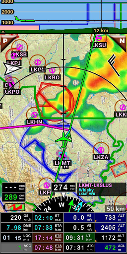


About this app
Developer Description
FLY is FUN - navigation for pilots 30 days trial version
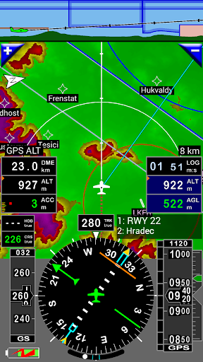
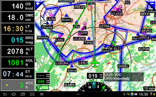
FLY is FUN simulates ILS approach, VOR, NDB, DME, Marker beacons, RNAV navigation and Marker beacons warnings, without ILS/VOR/NDB/RNAV equipment on board.
You can test FLY is FUN for free during few days. At the end of the trial period, pilot is invited to subscribe and pay an annual fees. Doing it, he get the right of using the application "as it is" and contribute to development effort.
FLY is FUN allows:
- Creating and modifying routes using "drag and drop", "rubber band"
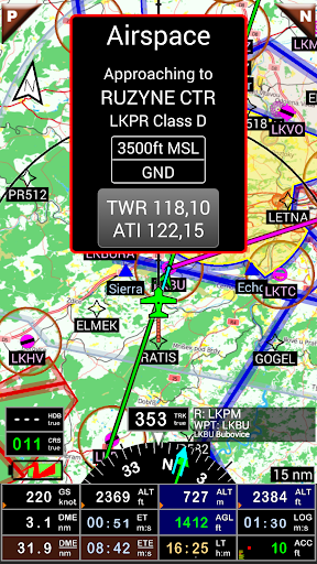
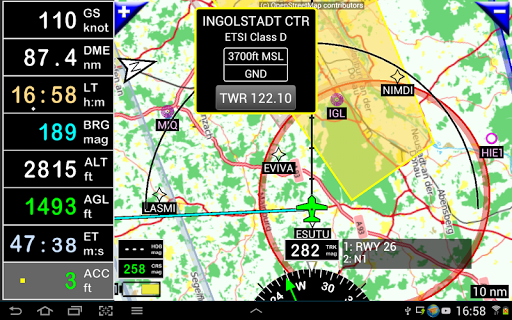
- Getting warnings, alarms and radio info before entering controlled or special use airspaces, approaching points
- Performing route planning, evaluating distance, time and fuel consumption (depending on wind and aircraft characteristics)
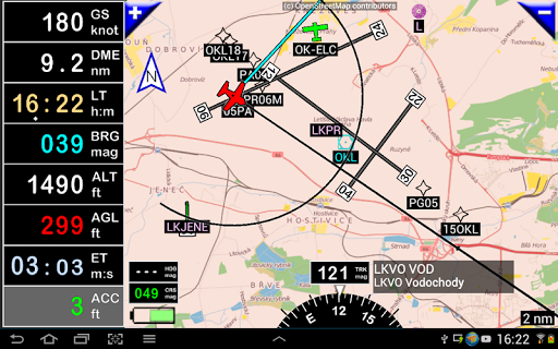
- Displaying route, bearing, trace on moving map
- Visualizing airspace
- Getting dynamic terrain map (colors depending of elevation above ground level)
- STRATUX support
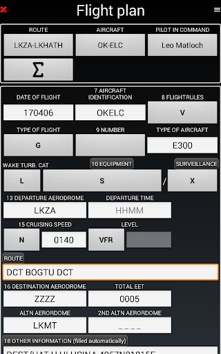
- Creating and exporting Flight Plan
- Creating and exporting Flight log
- Creating, importing or exporting routes, waypoints, RWY, airspace (Garmin .gpx, .kml, txt, OpenAir)
- Recording the flight and playing it back with Google Earth
- Sunset / Sunrise
- Getting weather forecast along the route
- Rainfall radar
- Wind displaying
- Calculating distance between 2 points on the map
- VACs
- Notepad
…
All main screens (5 portrait and 5 landscape could easily be customized. Pilot can choose from around 100 values to display. Example:
- Altitude GPS or barometric
- Ground speed
- Bearing
- Vertical speed
- DME to next point / destination
- Estimated time to next point / destination
- Time since departure
- Stop watch
…
Displayed information could be customized too depending of users preferences (VFR, IFR or both) and zoom level. The more you zoom IN, the more detail, information, waypoints,.. you see
Logbook
The integrated logbook, allows recording:
- Duration since departure time
- Departure and arrival time
- Departure and arrival airport
- Flight track (it is possible to export it as .kml or .gpx and to replay it)
- Used aircraft
- Pilot(s) and copilots in charge
- Distance, average speed, maximum speed
…
Navigation data available from open source database are updated according AIRAC cycles.
Charts and elevation dta
Free charts and elevation data are available for most of countries and could be imported directly via the application store.
Other charts could be created and imported by the pilot itself or made on request available as commercial service.
Pilots could select the most appropriate charts: free open source charts as well as commercial charts as ICAO, Cartabossy, SkyVector, FAA sectional and terminal charts…
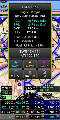
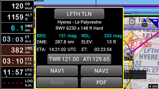
VACs and PDF files
VAC and AIP infos are available for more than 50 countries
User can easily attach your own PDF files.
Usage of external GPS connected via Bluetooth is possible
User guide: http://www.funair.cz/downloads/manuals/flyisfun.pdf
If you have any suggestion to improve this application or you find some bug please visit www.flyisfun.com
Use this application for VFR FLYING ONLY!!! We are not responsible for any use of this application.
What's New
In-app purchases
$0.99 - $54.99 per item
Version Information
- Version
- 35.34
- Downloads
- 100K+
- Updated on
- Dec 17, 2025
- Released
- Jan 20, 2012
- Requires
- Android 5.0
Statistics
Google Play Rating History
Rating Distribution
Downloads Over Time
FLY is FUN Aviation Navigation has been downloaded times. Over the past 30 days, it averaged downloads per day.
Shaded area shows 30-day prediction based on historical trends
Historical data collection started recently. More data points will be available over time.
FLY is FUN Aviation Navigation - Google Play Rankings
Top Rankings
| Rank | Country | Category | List | Change |
|---|---|---|---|---|
| — |
Ranking History in
No ranking data available yet. Rankings are updated daily.
#53 in Top Grossing Maps And Navigation in Spain
 Route Planner, Delivery, MyWay
FLY is FUN Aviation Navigation
Route Planner, Delivery, MyWay
FLY is FUN Aviation Navigation
 GPS Coordinates Locator Map
#85 in Top Grossing Maps And Navigation in Australia
 Hunting Points: GPS Hunt Map
FLY is FUN Aviation Navigation
Hunting Points: GPS Hunt Map
FLY is FUN Aviation Navigation
 Qibla Finder - Qibla Direction
#93 in Top Grossing Maps And Navigation in Brazil
 GPS Voice Navigation: GPS Maps
FLY is FUN Aviation Navigation
GPS Voice Navigation: GPS Maps
FLY is FUN Aviation Navigation
 Speed Cameras Radar NAVIGATOR
FLY is FUN Aviation Navigation users say on Google Play
 A Google user
its a great app, very help full.
 Vamsi Krishna
Does this app work with Apple phones or ipad?
A Google user
With open source maps, load-your-own ERSA & not CASA certified, it used to be a cheap & cheerful VFR companion. But with each update (all support to EU & USA) it becomes ever more troublesome. For downunder, add all the wierd terminology to mesmerizing and ballooning array of controls, I'm sad to say it is fast becoming a liability in the cockpit.
A Google user
First lifetime subscription, and then SORRY... At least you should provide discount for those who buy lifetime subscription.
A Google user
Really disappointing, bought and paid for lifetime license only to turn to subscription model. Really bad business practice and surely against the original agreement. Understand retirement to change but should be for new users coming to the app for the first time. I've recommended this app lots and now feel embarrassed for doing so.
ApkTrusted Ratings & Reviews
Similar Apps


Scan this QR code to download

Forwarding you to the page at Google Play market in seconds...
Open Google Play market now