
iFly EFB vVARY
Adventure Pilot, LLC


About this app
Developer Description
A powerful and intuitive EFB for both VFR and IFR flights.
iFly EFB offers unmatched value, powerful features, and intuitive usability for both VFR and IFR pilots. Quickly access the critical information you need so you can focus on what matters most: Flying.
Free 30-Day Trial
Try iFly EFB free for 30 days. No commitment — just fly and explore.
Requirements: Android 9.0 or higher, and 1GB+ of storage.
------------------------------------------------------------------
Core Features
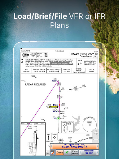
Flight Planning
Create simple direct-to or multi-waypoint routes directly on FAA charts, vector maps, or the Flight Plan page. Use drag-and-drop rubber-band routing to adjust your path in seconds. Patented RealPlan Automated VFR Flight Planning makes Cross Country planning a breeze.
Designed for General Aviation Pilots
iFly EFB is designed for General Aviation pilots: With large buttons and high contrast maps, iFly EFB supports you with quick access to information and data so you can stay focused on flying the aircraft.
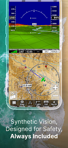
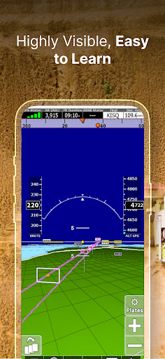
Synthetic Vision + 3D Traffic
See terrain and traffic in 3D to maximize situational awareness — works seamlessly on both phones and tablets.
Active Alerting System
Receive real-time alerts for airspace, terrain, traffic alert callouts, and more to keep you situationally aware.
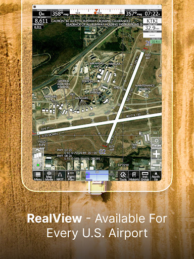
RealView Airports + AutoTaxi+
Satellite imagery for 12,600+ airports gives you visual familiarity before you land. AutoTaxi+ helps guide you safely on the ground.
Instruments Layouts
Simulates real cockpit instruments using GPS or third-party AHRS (e.g., HSI, VSI, Altimeter, Turn Indicator). Add an AHRS for an artificial horizon with attitude alerts.
Full US VFR/IFR Chart Access
Includes geo-referenced Sectionals, TACs, Low & High Enroute charts, approach plates, airport diagrams, and more.
Private & Public Airport Support
Tap into FAA-updated databases for public/private airports. Add your own custom waypoints for unmapped locations.
Aviation Weather Tools
Access pre-flight weather overlays with visual VFR/IFR data. Tap for detailed METARs, TAFs, and Winds Aloft.
ADS-B IN Support
Connect to iLevil, Stratus, uAvionix, Stratux, and many other ADS-B receivers for live weather and traffic — no extra cost.
------------------------------------------------------------------
Simple Subscriptions
VFR: All the core features for VFR Pilots, no paywalls for the features you need
IFR: Adds advanced tools for instrument-rated flying
The base subscription supports two Android devices. Upgrade to Multiplatform to use up to four devices across platforms.
------------------------------------------------------------------
Feature List
Map Layers:
• Sectionals, WAC, TAC
• Low/High-Enroute
• Vector Base Maps
• Geo-Referenced Plates & Diagrams
Map Modes:
• METARS, AIRMETS, NEXRAD, TAF
• Forecast (Clouds, Flight Conditions, etc.)
• Winds Aloft
• Glide Range Rings
• Terrain Highlights
• Fuel Prices
• Obstructions
Dynamic Overlays:
• Synthetic Vision with 3D Traffic
• Terrain, Obstructions, and Fuel Prices
• FAA Approach Plates
Tools & Interface:
• RealPlan: Automated VFR flight planning
• Instruments panel with 24+ layouts (incl. HSI, AHRS, vertical profile)
• Weight & Balance
• Checklists
• NOTAM Viewer
• Fly Direct-To
• Vertical Profile with Altitudes, Clouds, Flight Conditions, Airspaces, etc.
• Save/load flight plans & waypoints
• Emergency "Find Nearest" button
• Map orientation: North Up / Track Up
• Touch/pinch zoom & single-tap tools
• Day/Night mode & fading buttons
• Custom alerts (Terrain, Traffic, Airspace, Oxygen, Flight Plan)
• Custom waypoints
• Customizable instrument layouts
• Compatible with Microsoft Flight Simulator & X-Plane
What's New
In-app purchases
$0.99 - $179.99 per item
Version Information
- Version
- -
- Downloads
- 50K+
- Updated on
- Jun 8, 2025
- Released
- Jan 20, 2014
- Requires
- Android Varies with device
Statistics
Google Play Rating History
Rating Distribution
Downloads Over Time
iFly EFB has been downloaded times. Over the past 30 days, it averaged downloads per day.
Shaded area shows 30-day prediction based on historical trends
Historical data collection started recently. More data points will be available over time.
iFly EFB - Google Play Rankings
Top Rankings
| Rank | Country | Category | List | Change |
|---|---|---|---|---|
| — |
Ranking History in
No ranking data available yet. Rankings are updated daily.
#88 in Top Grossing Maps And Navigation in United States


iFly EFB users say on Google Play
 Mike Valler
I've been using iFly for a while now... I've used just about everything else out there and I've chosen iFly EFB .. and it's available on every platform! I have it on my phone, tablet and laptop. Check out their Real Plan feature, it's amazing! The entire platform is extreamely intuitive! It only gets better and better with every update! Their customer service is amazing!!!
 James Wagner
I had an issue with the update to iFLY EFB that was quickly resolved. Support has been very responsive to any issue I've raised. I still would like to be able to insert comments in the 'other' field and have been advised that is in the works. Otherwise, it is a fantastic app that is very intuitive and easy to use. I've tried Avare and Garmin Pilot, and this app was my final choice to use, especially flying multiple different aircraft. Flight planning and filing is wonderful.
 Tom Daly
Still not a contender to replace or even backup Garmin Pilot or Foreflight. Costs as much as GP with only 2 devices vs 3 on GP. No icing, generally poor WX feature, TFRs, and lacks other features. Updates take forever. The main reason for trying was it works with Stratux. Fltplan Go is still superior and free, but still not a replacement for GP or FF. After response from developer, I'll try it again after the next release.
 A . R
A . R
Takes for ever to boot. Instable, and regularly crashes. Update speed is inconsistent but worst is the amount of time the app take to connect for the maps server to upload. It still does not include the supplemental charts. The rest my family and friends has moved on, I need to do the same. I tried to provide feedback directly in the past, but none of my comments were taken into account... I am done, will not renew.
 John Sterner
Requires a subscription. They should tell you that before you spend hours downloading data and then they pop up a thing afterwards saying that it requires a subscription and they never tell you how much or anything until after your 30-day trial. I guess I don't know that's pretty shady
ApkTrusted Ratings & Reviews
Similar Apps


Scan this QR code to download

Forwarding you to the page at Google Play market in seconds...
Open Google Play market now