地図マピオン - 距離計測、海抜表示、マップコード表示も便利 vVARY
ONE COMPATH CO., LTD.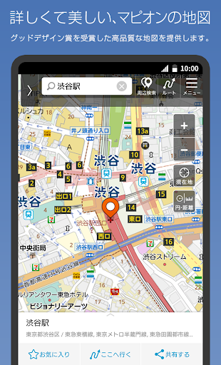


About this app
Developer Description
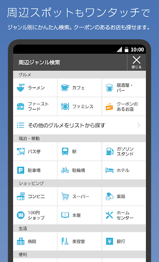
Detailed listings of buildings, station exits, bus stops, etc. Area boundaries and color coding are also convenient. You can tap between two points to get a straight line distance, or use a circle to get a sense of distance.
You can tap between two points on the map to measure a straight line distance, or use a circle that can be resized to get a sense of distance .
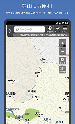
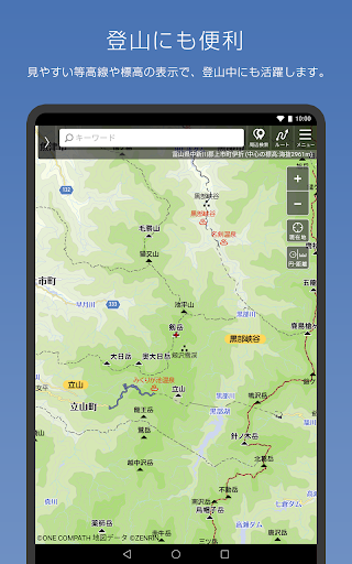
■ As a disaster prevention measure
You can see the "above sea level (elevation)" of the current location and the point where the map is displayed for the whole country.
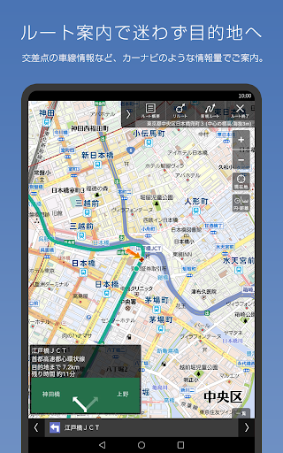
■ Map code indispensable for car navigation
The map code (*) is very convenient for setting the destination of the car navigation system.
Tap and hold the map on the Mapion app and tap the address to display the map code.
■ The boundaries are interesting
The "boundary line" of cities, wards, towns and villages and large letters and town chomes is clearly drawn.
Check the boundary with the neighboring town and train your sense of land.
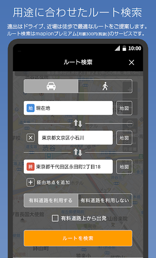
■ I want to move comfortably! We respond to such requests
We support you to move easily when you move on foot, such as "many roofs" and "fewer stairs".
■ Beautiful graphics
Mapion won the Good Design Award as an easy-to-understand map.
While highlighting necessary information such as station exits, detailed information is also posted, and the color coding of each city in the administrative world (city, ward, town, village, town Oaza, chome) and beautiful graphics like a paper map are applied. You can experience it at.
You can switch to a vector-based map, which also supports rotation and bird views. Bird view mode is a 3D representation at fine scale.
By remembering the "color" of roads and buildings, it becomes easier to understand the characteristics of the city, such as what kind of facilities are in what area, or what kind of city is the area where buildings of the same color are gathered. increase.
#road
Blue-purple ... highway
Orange ... National highway
Yellow: Major local roads such as prefectural roads
White ... general road
Ash ... Mountain trail, beast trail
#building
Blue-green ... Accommodation
Orange ・ ・ ・ Commercial facility
Purple ・ ・ ・ Leisure facility
Tea ... school
Red brown ... public facilities
Red ... hospital
Zhu ・ ・ ・ Station
■ Recommended terminal
Please use it on Android 5.1 or above. It may not work properly on some models.
■ Operating company
The "Mapion" and "Map Mapion" apps are services operated by ONE COMPATH Co., Ltd.
[Precautions]
This service uses the map function of Mapbox. Your location information will be sent anonymously and used to improve map functionality in accordance with the company's privacy policy. If you change your location information acquisition settings, " handling of personal information in the app You can opt out on the "About " page.
ONE COMPATH Co., Ltd. Handling of personal information
ONE COMPATH Co., Ltd. Terms of Use
* "Mapcode" and "MAPCODE" are registered trademarks of DENSO CORPORATION.
In-app purchases
$3.07 - $3.86 per item
Version Information
- Version
- -
- Downloads
- 1M+
- Updated on
- -
- Released
- Jul 8, 2010
- Requires
- Android Varies with device
Statistics
Google Play Rating History
Rating Distribution
Downloads Over Time
地図マピオン - 距離計測、海抜表示、マップコード表示も便利 has been downloaded times. Over the past 30 days, it averaged downloads per day.
Shaded area shows 30-day prediction based on historical trends
Historical data collection started recently. More data points will be available over time.
地図マピオン - 距離計測、海抜表示、マップコード表示も便利 - Google Play Rankings
Top Rankings
| Rank | Country | Category | List | Change |
|---|---|---|---|---|
| — |
Ranking History in
No ranking data available yet. Rankings are updated daily.
#41 in Top Grossing Maps And Navigation in Japan
 Live Earth Map - World Map 3D
地図マピオン - 距離計測、海抜表示、マップコード表示も便利
Live Earth Map - World Map 3D
地図マピオン - 距離計測、海抜表示、マップコード表示も便利
![Geographica [Offline GPS APP]](https://play-lh.googleusercontent.com/IS-bQR8KAN1kYJuJdrSJqHltsfbMZYqMlZ05AbAMRw49GHC35ZsUez2YTO_RP0V_4g) Geographica [Offline GPS APP]
Geographica [Offline GPS APP]
#49 in Top Free Maps And Navigation in Japan


地図マピオン - 距離計測、海抜表示、マップコード表示も便利 users say on Google Play
 さなぎのなかみ。
グーグルマップやヤフーマップに比べ、建物や道路の線形などが細かく表示されるため細部が確認しやすく重宝しております。また、常時標高が表示される機能は大変重宝しています。(同様の機能は地理院地図にもある) 田舎町の中心地などの地図がかなり雑で、省略箇所が多い点が残念です。ゼンリンベースでなくなったことが響いているのでしょうか。少々扱いづらいUIである点が残念ですが、今後の改良に期待しながら末永く使おうと思います。
 A Google user
モバイルサイトで無料会員でもログインできるので、アプリではプレミアム会員じゃない限り実用性が微妙。
 Takeo Shirasaka
ルート検索の画面で、デバイスを90度傾けると地図の上下もそれに合わせるように地図とルートが再描画されるが、その際にアプリが落ちたり、ルート検索画面が強制的に終わってしまう事がある。運転中にこの症状が出るので大変困る。有料機能なのにこれでは悲しい。
A Google user
Good
ApkTrusted Ratings & Reviews
More from ONE COMPATH CO., LTD.
See more apps


Scan this QR code to download

Forwarding you to the page at Google Play market in seconds...
Open Google Play market now