
山と高原地図 v1.6.10
株式会社昭文社
About this app
Developer Description
Share No. 1 climbing map "Mountain and Takahara Map" application version First of all, try 'Takao mountain' for free download
The 2025 version of the 63 area map has been updated. When climbing, be sure to update to the latest map before heading out!
■Price
・The app itself is free
・Map 1 area 650 yen
You can now download "Mt. Takao" for free, so give it a try first.
*This app is designed to be purchased by area.
*There is no expiration date for the purchased map (this year's version). However, maps that will be updated from the following year onwards (new year edition) will need to be purchased anew.
*Even if you change to a different Android device, you can transfer the purchased maps as long as you use the same Google account. Please re-download from the "Purchased List" within the app.
*Map cannot be transferred between iPhone/Android devices.
★With the sister app "Mountain and Highland Map Hodai", you can use the latest maps of all areas as much as you like for a fixed fee (500 yen/month or 4,800 yen/year). As an original feature, you can also create a mountain climbing route plan. Try it free for 7 days first.
https://rd.mapple-apps.jp/api/url.php?redid=72
■Main features
①Easy-to-read map with abundant mountain climbing information
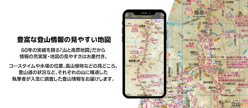
Since it is a ``mountain and plateau map'' that boasts a 60-year track record, it is guaranteed that the information is complete and the maps are easy to read. We deliver mountain climbing information that has been carefully researched by authors who are familiar with each mountain, including course times, locations of water holes, highlights such as alpine plants, and mountain trail conditions.
② Can be used even outside the service area!
All maps are downloaded in advance and saved on your device, so you can use them even in the mountains where there is no signal. You can save battery power by using airplane mode.
③ Know your current location!
You can rest assured knowing your location on the map of "Mountains and Highlands Map" using GPS.
④Route can be recorded!
You can not only view the recorded routes within the app, but also send them via email, so you can organize your climbing records on your PC or post them to external sites such as YamaReco.
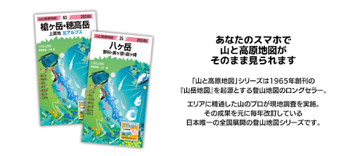
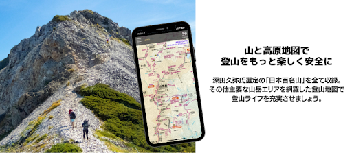
⑤ Covering Japan's 100 famous mountains!
All 63 "Mountain and Highland Maps" have been made into an app. It covers Japan's famous mountains, including all of Japan's 100 Famous Mountains, from Hokkaido in the north to Yakushima in the south.
■Recorded content
- Contains the mountain climbing map from the book map ``Mountains and Highlands Map'' (surrounding maps, information published in the booklet, etc. are not included). Please check the product details in the app for included maps.
・Considering ease of viewing and operability on smartphones, we have made modifications such as omitting topographical expressions and latitude and longitude lines.
■Supported OS
・Android OS 4.4 or later (may not work on some models)
*Cannot be used on models that are not compatible with Play Store.
(Easy smartphones, Kindle devices, fire devices, etc.)
*If your device is not equipped with GPS, you cannot display your current location or record your route.
*GPS performance varies greatly depending on the model and OS.
*Since it may not work on some models, we recommend that you check the following after downloading the app and before purchasing the map.
1 Map display…Please download and check the free map of Mt. Takao.
2 GPS related…Route recording is possible even outside the map area. Please display the map of Mt. Takao, record the route, send it to your PC, and check if it can be displayed on Google Earth, etc. If you do it in airplane mode, the test will be similar to the environment you are climbing. Please see the in-app help for operating instructions such as how to send to a PC.
■Note
・As the data for each area is large (approximately 10-25MB), we recommend downloading using a Wi-Fi connection.
・The function that records routes in the background consumes a lot of battery power. In order to ensure a means of communication in case of an emergency, we recommend setting to conserve battery (see the in-app help for setting instructions).
・Be sure to use it in conjunction with a book map in case the battery runs out.
・The investigation period for published information is stated in "Notice/Help" > "Credit Notation" in the app. For the sake of research, some areas include their previous state. Also, the conditions of the mountain climbing area, such as the condition of mountain trails and the operation of facilities, may change significantly due to heavy rain, wind and snow, etc., so please make your own decisions and act carefully at your own risk. For your safety, please be sure to check the situation with the local government office before hiking.
・The posted information is not based on GPS positioning, so it may differ from the actual location. Additionally, the accuracy of the location obtained with this app may decrease depending on the surrounding topography. Please do not rely solely on the location information provided by this app, but rather comprehensively judge the surrounding terrain, etc., before taking action.
・Please note that we cannot be held responsible for any accidents or distress.
What's New
In-app purchases
$2.76 - $4.69 per item
Version Information
- Version
- 1.6.10
- Downloads
- 100K+
- Updated on
- Nov 25, 2025
- Released
- Feb 11, 2013
- Requires
- Android 5.0
Statistics
Google Play Rating History
Rating Distribution
Downloads Over Time
山と高原地図 has been downloaded times. Over the past 30 days, it averaged downloads per day.
Shaded area shows 30-day prediction based on historical trends
Historical data collection started recently. More data points will be available over time.
山と高原地図 - Google Play Rankings
Top Rankings
| Rank | Country | Category | List | Change |
|---|---|---|---|---|
| — |
Ranking History in
No ranking data available yet. Rankings are updated daily.
#12 in Top Grossing Travel And Local in Japan


山と高原地図 users say on Google Play
 A Google user
Use it all the time, fantastic. Would be nice if there was an easier way to find out what map has what part of Japan. Right now you have to open several maps and see which one covers the area you're looking for.
A Google user
It's a very useful app but the addition of an English interface for people with poor Japanese would be fantastic.
A Google user
Very useful maps for hiking Japanese mountains. The time period is given how long it takes to walk from one point to another. There is an option to record the GPS track. Physical map can be bought off Amazon but it costs 1000 yen. 500 yen for one digital map is a little too much.
ApkTrusted Ratings & Reviews
More from 株式会社昭文社
See more apps


Scan this QR code to download

Forwarding you to the page at Google Play market in seconds...
Open Google Play market now