
mBDL v2.3.0
Biuro Urządzania Lasu i Geodezji Leśnej


About this app
Developer Description
mBDL is an application that provides map resources of the Data Bank on the Forests.
After downloading the appropriate data, the application also works when there is no connection to the Internet. The mechanism of downloading data for offline work enables the use of maps of forest districts and national parks. Together with the maps, which are saved in raster form, vector data with descriptive attributes are downloaded for PGL LP forests.
From the level of the mBDL application, the user has online access to a full taxation description for forests of all ownership forms. Such a description includes species of trees and shrubs occurring in a given place, their detailed description, forest address, economic indications and many other information.
The application is additionally equipped with a number of functionalities useful in the field: area and distance measurement, recording a point from a GPS location or from a map indication, recording a route and simple navigation to a given point. Saved waypoints and routes can be exported as a KML file, sent to the world in any way or imported on another device on which the mBDL application is also installed.
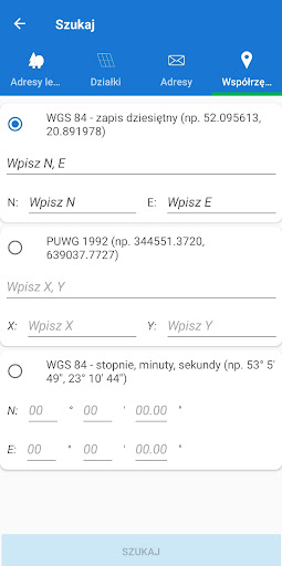
In mBDL, you can search for forest divisions based on the so-called forest address, cadastral parcels or point by means of its coordinates.
In the Help menu, there is also a manual describing the basic functionalities, which is worth getting acquainted with at the beginning of using the application.
Declaration of availability: https://www.bdl.lasy.gov.pl/portal/deklaracja-mbdl
What's New
2. We have improved the route recording mechanism.
3. We have improved the data download mechanism for offline use.
4. We have improved the legend presentation in offline mode.
5. We have improved the measurement export to KML/GPX files mechanism.
6. We have improved the data upload mechanism from WMS services.
Version Information
- Version
- 2.3.0
- Downloads
- 500K+
- Updated on
- Oct 31, 2025
- Released
- Nov 30, 2018
- Requires
- Android 5.1
Statistics
Google Play Rating History
Rating Distribution
Downloads Over Time
mBDL has been downloaded times. Over the past 30 days, it averaged downloads per day.
Shaded area shows 30-day prediction based on historical trends
Historical data collection started recently. More data points will be available over time.
mBDL - Google Play Rankings
Top Rankings
| Rank | Country | Category | List | Change |
|---|---|---|---|---|
| — |
Ranking History in
No ranking data available yet. Rankings are updated daily.
#49 in Top Free Maps And Navigation in Poland
mBDL users say on Google Play
 Lukasz N.
Kapitalna aplikacja, niezwykle użyteczna podczas leśnych wędrówek. Ma wielki potencjał na bycie must-have do świadomej turystyki. Oprócz naniesienia warstwy ze szlakami, co było proponowane już wcześniej, sugeruję dodanie możliwości 'zafiksowania' północy na stałe - podczas przybliżania/oddalania palcami najczęściej orientacja mapy ulega dewiacji, co wymusza dodatkowy 'klik' aby przywrócić kierunek N.
 Przemysław Brzeziński
Bardzo użyteczna aplikacja, niestety od jakiego czasu prawie zawsze zawiesza się po załadaniu, widoczny jest jedynie interfejs, mapa się nie ładuje, nie da się wykonać żadnej czynności, aplikacja nie odpowiada. Moje urządzenie- Redmi note 8 pro
 Tiny Woodentree
App is great content wise but sucks. I have to clear storage and cache every time I'm starting it and occasionally I have to reinstall because it keeps freezing every time it's opened. Otherwise it would be awesome. Edit: I almost want to reduce another star for that Developer answer... I can't read the language and it was more than half a year ago. What's the point?
 A Google user
Po włączeniu pokazuje się mapa, można znaleźć swoją pozycję na podstawie GPS ale nie da się pozyskać żadnych informacji o lasach ponieważ dalsze działanie powoduje błąd i wyłączenie aplikacji.
 86kotek
Niestety zamyka sie zaraz po otwarciu na Pixel 6Pro z najnowszymi aktualizacjami, a szkoda bo na starszych telefonach dziala i jest swietna aplikacja
ApkTrusted Ratings & Reviews
Scan this QR code to download

Forwarding you to the page at Google Play market in seconds...
Open Google Play market now