
GPS Altimeter - Map Camera vVARY
handcoded apps


About this app
Developer Description
GPS altimeter for accurate altitude with map camera and geotag photos
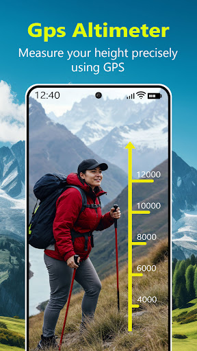
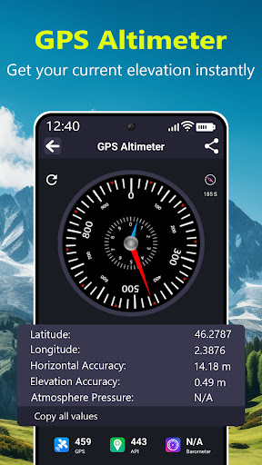
🏔️GPS Altimeter – Measure Altitude
Instantly view your current altitude and measure elevation using the GPS altimeter. Ideal for hikers, climbers, and adventurers, the altimeter tracker provides elevation data based on both GPS and barometric sensors (if available). Know what’s my altitude at any location. It also works as a handy barometer app for measuring pressure and elevation.
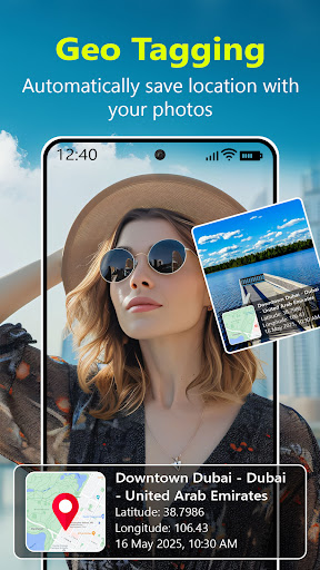
📍GPS Map Camera – GeoTag Photos
Capture and save memories with precise GPS map camera functionality. Automatically tag your photos with latitude, longitude, altitude, date, and time using the built-in geo-tagging camera. Perfect for travelers, field workers, and survey professionals, this GPS camera photo with location ensures your photos always have exact location information. Use it as a GPS field camera for documenting surveys or trips with accuracy.
🚗Speedometer – GPS Speed Tracker
Keep track of your current speed in real-time using the GPS speedometer. This speed tracker shows your speed in mph or km/h, with an intuitive display designed for driving, cycling, or walking. It's also useful as a speedometer for car, showing average and max speeds with speed limit alerts for safety.
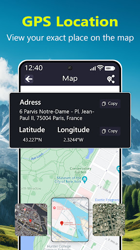
🗺️Live Map – Satellite View
Explore the world with the live earth map feature, offering detailed satellite view, street map, and real-time location tracking. Whether you're checking terrain or viewing your surroundings, the live map helps you stay oriented and informed. Easily switch between different map types to suit your needs.
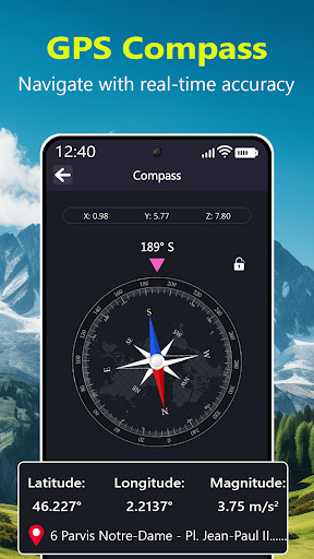
🧭Compass – Find Directions Easily
Stay on track with a highly responsive digital compass. Whether you're navigating in the wild or finding your way in the city, the smart compass ensures accurate directions using your phone’s sensors and GPS. It supports both magnetic and true north modes, making it your go-to GPS compass for travel and exploration.
📏Level Meter – Bubble & Spirit Level
Level any surface using the precise bubble level tool. Ideal for carpenters, handymen, and home DIYers, the spirit level helps you align shelves, furniture, or other objects perfectly. With both vertical and horizontal leveling, it works as an accurate and convenient level meter and leveling tool.
🌐Multi-Feature Utility in One App
This app combines essential tools in a compact, easy-to-use interface. Whether you're documenting locations with the photo map, checking altitude, monitoring speed, or using the compass and level, this all-in-one tool is designed to serve explorers, field workers, travelers, and outdoor enthusiasts.
GPS Altimeter - GPS Map Camera Key Features at a Glance:
📸 GPS Camera with photo location stamp
🏔️ Accurate GPS Altimeter and elevation tracker
🧭 Digital Compass with direction finder
🚗 GPS Speedometer and speed tracking
🗺️ Live Maps with satellite view
📏 Bubble Level & Surface Level tool
📍 Show Latitude, Longitude, and GPS coordinates
⛅ Barometer support (if available on device)
Whether you're in the mountains or the city, GPS Altimeter & Compass gives you everything you need to navigate, measure, document, and explore with confidence. Download now and turn your phone into a smart, multi-tool device!
Version Information
- Version
- -
- Downloads
- 100+
- Updated on
- -
- Released
- May 29, 2025
- Requires
- Android Varies with device
Statistics
Google Play Rating History
Rating Distribution
Downloads Over Time
GPS Altimeter - Map Camera has been downloaded times. Over the past 30 days, it averaged downloads per day.
Shaded area shows 30-day prediction based on historical trends
Historical data collection started recently. More data points will be available over time.
ApkTrusted Ratings & Reviews
More from handcoded apps
See more apps

Scan this QR code to download

Forwarding you to the page at Google Play market in seconds...
Open Google Play market now