
BRMB Maps by Backroad Maps v3.6.0
Backroad Mapbooks


About this app
Developer Description
Fish, Hunt, Camp, Hike, Bike, Ride & Explore with Canada’s Backcountry Map App
Explore Canada’s outdoors with confidence using BRMB Maps, the most detailed and trusted GPS navigation app for the backcountry. Built from the award-winning Backroad Mapbooks series, BRMB Maps combines detailed topographic maps with over 900,000 searchable Points of Interest across every province and territory.
Whether you're into fishing, camping, hiking, hunting, paddling, ATVing, snowmobiling, or wildlife viewing, BRMB Maps has everything you need to plan, navigate, and explore – online or offline.
🧭 Key Features
Topographic GPS Maps: View relief shading, contour lines, backroads, parks, and geographic features
Current Location Tracking: Use your phone’s GPS to navigate in real time
Cross-Device Access: Use on smartphone, tablet, and desktop with a single account
Canada-Wide Basemap: Includes a seamless basemap from Backroad Maps across Canada
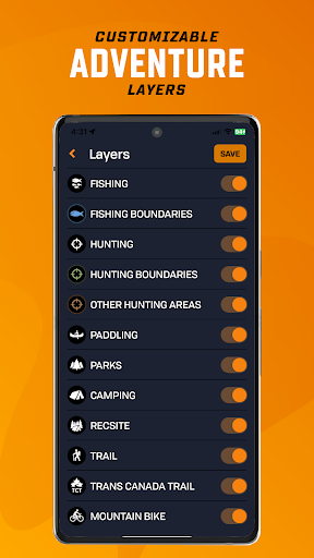
Custom Adventure Layers: Enable fishing, hunting, trails, paddling, Crown land & more
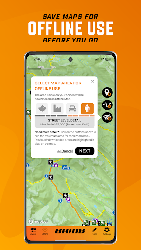
Offline Maps: Download maps and all POI details for off-grid navigation
Satellite Imagery: Overlay roads, trails, and features on high-res satellite maps
Trip Recording & Custom Waypoints: Track routes, mark campsites, and save locations
Printable Custom Maps: Create and print stunning maps from brmbmaps.com
🔍 Explore Over 150,000 Adventure Sites
Fishing 🎣
22,000+ lakes, rivers, creeks & ocean fishing areas
Bathymetry (lake & ocean depths), fish species, stocked lakes, boat launches & marinas
Zone boundaries & regulation links
Hunting 🦌
3,500+ hunting areas (WMUs/WMZs/GMAs, species-specific zones)
Species details, boundaries & regulation info
Crown land access & private land overlays
Camping & Parks
20,000 national, provincial, regional, urban, conservation and natural parks
Campsites, picnic areas, backcountry campsites, backcountry huts & cabins
Private campgrounds, resorts & lodges, amenities & services
Hiking, Biking & Horseback Trails
130,000+ km of multi-use trails with trailheads, difficulty ratings, distance & elevation gain
Includes hiking, mountain biking, cycling, horseback riding, backpacking, and multi-use
Separate Trans-Canada Trail layer with trailheads, pavilions and alternate routes
Paddling (Canoeing & Kayaking)
107,000+ km of routes with access points, difficulty ratings, distance & grading
Features lake circuits, river and ocean paddling routes, whitewater & more
Paddling routes include portages with distances, campsites, put-ins & take-outs
ATV, OHV, Off-Road and Overland Routes
160,000+ km of trails and routes with staging areas, difficulty ratings & distance
Features ATV/OHV, dirt biking, and overlanding route options
Plus 3,000,000+ km of Roads and 160,000+ km of Logging Roads to explore
Snowmobiling
150,000+ km of trails and routes with staging areas, difficulty ratings & distance
Features federation & club-maintained trails, plus backcountry routes
Clubhouses, warming huts & shelters, side trails and more
Winter Recreation
9,500+ km of ski & snowshoe trails for cross-country, Nordic, backcountry & downhill skiing
2,100+ trailheads, Nordic areas & ski centres
Trails features difficulty ratings, distance, elevation gain & ski area amenities
Wildlife Viewing & Nature
1,800+ sites for birdwatching & wildlife viewing
Features birding sites, fish hatcheries & spawning areas, marine life, small animals & large mammals
Bird viewing & scenic lookouts, trailheads & wildlife centres
Attractions & Unique Sites
20,000+ points, including roadside and backcountry attractions
Features big trees, caves, waterfalls, hot springs, lighthouses, beaches, museums and scenic areas
Commercial sites include hours, location and contact information
Why BRMB Maps?
Unlike other GPS apps, BRMB Maps is built specifically for Canadian terrain and adventure types, with unmatched detail, local insights, and recreation-focused layers. Trusted by search & rescue teams, guides, hunters, anglers and explorers for over 30 years.
What's New
- Hunting layers feature species imagery, detailed write-ups, and improved POIs across Canada
- Enjoy faster, more stable maps with upgraded core mapping.
- Improved basemap colours for better visibility
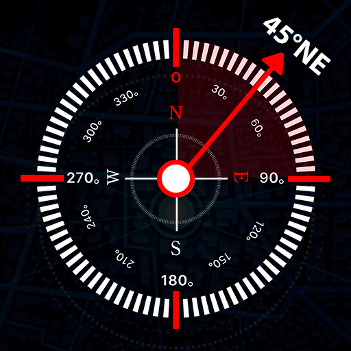
- Always-visible GPS direction arrow
- New “Press to Drop Waypoint” option
- UI refinements and bug fixes
In-app purchases
$3.49 - $43.99 per item
Version Information
- Version
- 3.6.0
- Downloads
- 50K+
- Updated on
- Nov 6, 2025
- Released
- Aug 28, 2020
- Requires
- Android 7.0
Statistics
Google Play Rating History
Rating Distribution
Downloads Over Time
BRMB Maps by Backroad Maps has been downloaded times. Over the past 30 days, it averaged downloads per day.
Shaded area shows 30-day prediction based on historical trends
Historical data collection started recently. More data points will be available over time.
BRMB Maps by Backroad Maps - Google Play Rankings
Top Rankings
| Rank | Country | Category | List | Change |
|---|---|---|---|---|
| — |
Ranking History in
No ranking data available yet. Rankings are updated daily.
#8 in Top Grossing Maps And Navigation in Canada

BRMB Maps by Backroad Maps users say on Google Play
 Vancouver Adventurer
as of the last few days the app force closes and crashes on startup, I've tried reinstalling with no avail. now I'm stuck with a paid version that doesn't even open. it crashes when it Access my location. the app only starts when I block permissions for location, then it crashes when I click allow this time only. EDIT *** THEY Updated THE APP within 4 days and fixed the problem. 5 stars.
 Russ Dodd
I have been a paid subscriber for a while. app is great works fantastic almost all the time but I went to look at it this morning and as somebody else's complained it just crashes and crashes and crashes. As this is a paid subscription I am hoping this will be fixed ASAP. Never had any problems before though so if this gets fixed ASAP. Both my tablet and phone (Samsung) have the problem.
 ECPL C
Just started using the app. It appears to have some bugs. The first you will notice is that you cannot search without the GPS location signal being turned on. It just simply crashes. So, you cannot plan trips without turning on your location. Even if your planning is being done on another device that never leaves home.
 M V
M V
search function causes full crash after last update. seems every time I need to use the app it crashes these days.
 Matt Keating
Frustrating. I have had a subscription since 2021. WHEN the app works, it's fantastic. It doesn't work very often. Lots of places I plan bike trips in don't have cell service, and Google maps struggles. So I use this. But now I also need paper maps, and several phones because this app always crashes and/or tells me my password is wrong.
ApkTrusted Ratings & Reviews
More from Backroad Mapbooks
See more apps
Similar Apps


Scan this QR code to download

Forwarding you to the page at Google Play market in seconds...
Open Google Play market now