
Bruce Trail App v1.10.46
Bruce Trail Conservancy


About this app
Developer Description
Explore Canada’s longest marked footpath with this official Bruce Trail App.
=> Available for FREE 7-day trial followed by subscription for $2.99/month or $29.99/year. <= (When you download the app, you'll be asked to set up your subscription but will NOT be charged until the free trial period is over.)
Find your way with the most up-to-date Bruce Trail information and helpful navigational tools.
Did you know the actual route of the Bruce Trail changes often? With the Bruce Trail App, you’ll have automatically updated Trail information, direct from the Bruce Trail Conservancy, right in the palm of your hand for stress-free adventures.
With over 1,300 km of trail along the Niagara Escarpment, there is so much to explore. The Bruce Trail App can help beginner hikers, seasoned explorers, and aspiring End-to-Enders alike!
The Bruce Trail App features the 42 official Bruce Trail maps from Queenston to Tobermory. Carry your map wherever, whenever, even with no cell service on the Trail. Easily download individual maps, or the full set, to have a map layer that works when the app is offline.
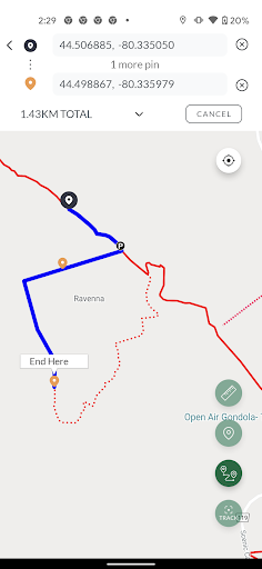
Plan custom routes and measure distances. Find details on parking and camping. Follow your location on the Bruce Trail in real time, track and save your hikes, and more.
Proceeds from app subscriptions go to the Bruce Trail Conservancy to help maintain the app, care for the Trail, and support our conservation work.
---
Sponsored by Ontario Power Generation
__
FEATURES:
=> Explore over 1,300 km of trails on the Niagara Escarpment:
View the full 900 km main Bruce Trail and over 400 km of associated side trails, from Queenston to Tobermory.
=> Find Parking and Camping Information:
Clearly see locations of Trail access points, parking locations, and official camping sites. Get directions, and links to parking/camping reservations, with a simple tap.
=> Customize Your Map View:
View the Bruce Trail on any of 4 different map layers: default, terrain, satellite, or the Bruce Trail Conservancy topographic maps. Use map filters to show only the data you want to see.
=> Measure Distances and Plan Routes:
Tap along the Trail to plan your route and measure the distance you will be hiking. Use the Measurement tool for simple A-to-B distances, or the Route tool to measure and plan a hike involving loops or multiple trails.
=> Track and Record Hikes:
See your location on the Trail. Record your day's hike and see how far you have travelled. Keep a log of all your tracked hikes and watch your progress grow.
=> Download Bruce Trail Maps for Offline Use:
When you have cellular or Wi-Fi access, download some or all of the Bruce Trail maps with one tap. You can be certain all the data you need is on your device when you head out on the Trail.
=> Explore Our Protected Natural Areas:
Discover the growing network of Bruce Trail Conservancy nature reserves and other protected areas cared for by the BTC. Witness the addition of newly protected land to the Bruce Trail's conservation corridor.
=> Search:
Quickly locate important places by name, like Bruce Trail sections, side trails, local towns, map regions, Bruce Trail Conservancy protected natural areas, and campgrounds.
=> Other information:
Find useful information about Trail safety, navigation, and Bruce Trail news in an easy reference menu
=> More features to come
---
Subscription Details
7-day FREE trial period followed by subscription of $2.99/month or $29.99/annually.
You can subscribe and pay through your Google Play account. Your subscription will automatically renew unless cancelled at least 24 hours before the end of the current period. Auto-renew can be turned off anytime by going to your My Subscriptions page on Google Play.
What's New
Other improvements in this version:
- Greater zoom capability
- Display fix for boundaries of BTC Protected Natural Areas
- Display fix for off-road parking locations
We continue to work on improvements, fixes & new features. Contact us at info@brucetrail.org to share your ideas or feedback.
In-app purchases
$2.49 - $22.99 per item
Version Information
- Version
- 1.10.46
- Downloads
- 10K+
- Updated on
- Jan 9, 2026
- Released
- Oct 27, 2021
- Requires
- Android 5.0
Statistics
Google Play Rating History
Rating Distribution
Downloads Over Time
Bruce Trail App has been downloaded times. Over the past 30 days, it averaged downloads per day.
Shaded area shows 30-day prediction based on historical trends
Historical data collection started recently. More data points will be available over time.
Bruce Trail App - Google Play Rankings
Top Rankings
| Rank | Country | Category | List | Change |
|---|---|---|---|---|
| — |
Ranking History in
No ranking data available yet. Rankings are updated daily.
#12 in Top Grossing Maps And Navigation in Canada


Bruce Trail App users say on Google Play
 Marcel Gerou
This is an excellent app, and an essential resource for navigating the Bruce Trail. I purchased the conservatory's pdf map as well. However, I find this app far more useful and detailed. I really appreciate all the parking information and that it features both lot and roadside locations. Also, the map is frequently updated to include any crucial updates or changes on the trail. Anyway, its well worth the subscription price.
 Caroline Leighton
This is a great app! I love being able to track my routes and start where I previously stopped so I don't miss a step of the BT. Missing a star because the report a trail issue function is glitchy, but most of all, I'd love it if I was able to see ALL my tracked hikes on ONE map so I can determine where I haven't been. I'd also love a different color than light orange for the tracked hikes on the map. It's quite hard to see against the red bruce trail. Happy hiking! 😄
 James Crawford
It can be frustrating how it tries to load live data when I don't have a connection. I download sections of map, but if I'm in a spot with poor reception it's like the app is trying to download the maps rather than use cached ones. If I turn data off it works fine though. App could be a little smarter.
 Clair Bonanno
Pretty buggy when used on android
 Anthony S.
Literally doesn't work. Don't have an account, so I make one, then it asks if I want to try monthly or yearly subscription model, and the buttons are broken links. Hit either option and it stays on the same screen. Website is no better. Can't create an account on there. Totally broken digital infrastructure for such a great trail and organization otherwise. Really need better IT management since some people who also pay into this system would like digital tools to access the maps.
ApkTrusted Ratings & Reviews
Similar Apps


Scan this QR code to download

Forwarding you to the page at Google Play market in seconds...
Open Google Play market now