
SityTrail+ vVARY
Geolives Belgium S.R.L.


About this app
Developer Description
Hiking GPS for all your outdoor activities in the world !
Whether you're a passionate hiker, avid cyclist, winter sports enthusiast, or simply looking for adventure and discovery, SityTrail accompanies you everywhere, anytime, with complete ease.
✨ Discover our FREE Freemium features:
✅ Record your adventures!
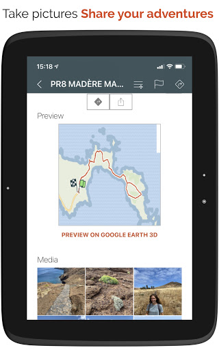
• Save your hikes with geotagged photos.
• Track your performance: distance, effort (Km-effort), average speed, pace, calories burned.
✅ Navigate safely!
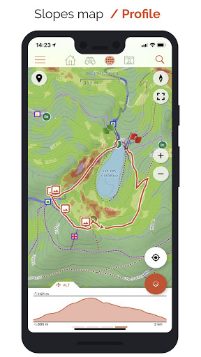
• Precise altimeter with interactive elevation profile.
• Automatic alarm if you stray from your route to avoid getting lost.
• Automatic activation of points of interest with voice descriptions.
✅ Easily plan and share!
• Create and edit trails and points of interest directly from our website.
• Access your projects online and instantly retrieve them on your Android or iOS smartphone.
• Sort and organize your favorite routes in personal lists.
✅ Universal access!
• Create a free account to synchronize your data across all your devices.
• Discreet advertisements displayed only to finance our free servers.
🚀 Upgrade to Premium for unlimited adventures!
🌟 Premium maps and offline mode
• Download detailed topographic maps by area (IGN France, SwissTopo, Luxembourg, United Kingdom, and our worldwide Geolives topographic maps).
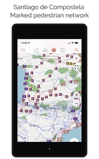
• Access the best hiking networks (GR, PR, European routes, Santiago de Compostela routes).
• Discover cycling routes (Voies vertes in France, Ravel in Belgium, Node networks in the Netherlands).
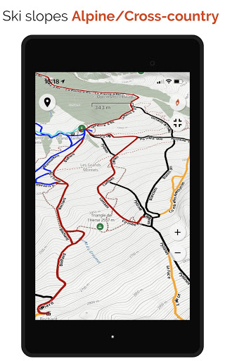
• Easily identify ski slopes by their colors and names.
🌟 Optimized guidance and safety
• Benefit from advanced vocal GPS guidance with precise Roadbook symbols.
• Let yourself be guided easily with clear visual symbols at each intersection or direction change. You'll always know exactly which trail to follow, even without technical knowledge!
• Easily estimate remaining distance and time with clear, realistic displays.
🌟 Active and collaborative community
• Explore the public catalog of the community’s favorite trails.
• Transform your hikes into true multimedia guides enriched with texts, photos, and videos, and share them with other users.
• Create your own communities, easily manage members, and share your news.
🌟 Advanced editing and printing features
• Precisely edit your trails through our web platform.
• Easily print your hiking maps in PDF format (A4 or A3) with an integrated QR Code.
⌚ Compatible with your smartwatch
• Record and follow your trails directly from your Wear OS or Garmin smartwatch, including remaining time estimates and realistic visual guidance with accurate Roadbook symbols!
⚠️ Important information:
• Some features require an internet connection.
• Prolonged GPS use may decrease battery life.
🚶♂️🚴♀️🎿 With SityTrail, fully enjoy your outdoor passions and discover new horizons with every outing!
What's New
- The track reversal must now be defined when opening the hike
- Added a preference allowing users to choose whether the automatic removal of out-and-back sections should be enabled by default
In-app purchases
$26.99 - $59.99 per item
Version Information
- Version
- -
- Downloads
- 10K+
- Updated on
- Dec 4, 2025
- Released
- Sep 28, 2020
- Requires
- Android Varies with device
Statistics
Google Play Rating History
Rating Distribution
Downloads Over Time
SityTrail+ has been downloaded times. Over the past 30 days, it averaged downloads per day.
Shaded area shows 30-day prediction based on historical trends
Historical data collection started recently. More data points will be available over time.
SityTrail+ - Google Play Rankings
Top Rankings
| Rank | Country | Category | List | Change |
|---|---|---|---|---|
| — |
Ranking History in
No ranking data available yet. Rankings are updated daily.
#75 in Top Grossing Travel And Local in France


SityTrail+ users say on Google Play
 Peter P
Great Hiking Company
 Fabrice DESSART
Used it in France and was quite ok. Moved to Canada and the world hiking version is useless as there are never hikes according to the app but I know lot of them in the area with many national Parks.
ApkTrusted Ratings & Reviews
More from Geolives Belgium S.R.L.
See more apps
Scan this QR code to download

Forwarding you to the page at Google Play market in seconds...
Open Google Play market now