
SityTrail hiking trail GPS vVARY
Geolives Belgium S.R.L.


About this app
Developer Description
Hiking GPS for all your outdoor activities in the world !
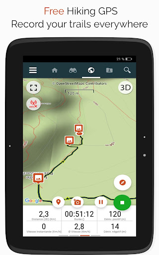
• Record your trails while taking HD and geo-tagged pictures of your adventures.
• Travelled distance, Km-effort, average speed, calories burned, etc.
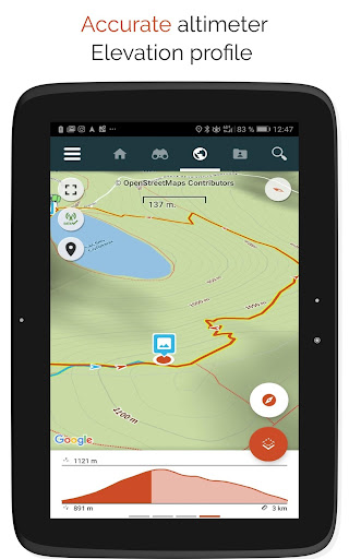
• Accurate altimeter, height differences computing and elevation profile displaying your current location.
• Alarm when you go off the path of the trail being followed. No more need to backtrack!
• Automatic triggering of points of interest with text-to-speech.
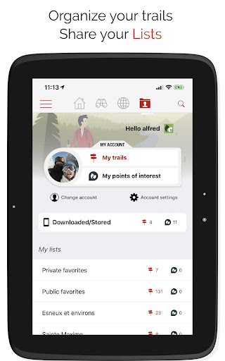
• Create a free account and all your data will be available everywhere on every device.
• Easy creation of trails and points of interest from our website.
• With our online editor, create your own trails using a Web browser on your PC/Mac and then access them directly from your smartphone to experience them on the ground.
• Sort and classify your trails and points of interest in your own lists.
Go further and become a PREMIUM user!
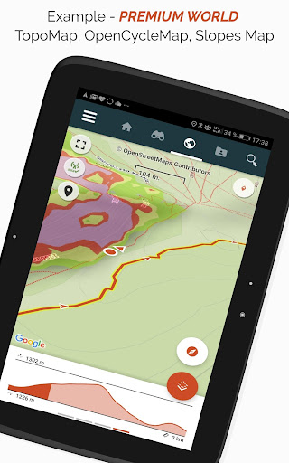
• Download world topographic maps for offline use.
• Discover GR hiking paths, European hiking routes, Santiago de Compostela routes for pilgrims, etc.
• Add topographic maps of your choice, from IGN France, IGN / NGI Belgium, IGN Spain, swisstopo, Austria, USA (USGS topographic mapping), Canada (Toporama).
• You can also discover all cycling networks: Greenway network in France, Ravel in Belgium, European cycling routes, knot points networks in Flanders and the Netherlands.
• And in winter, discover all the ski slopes with their names.
• Access the public catalogue of trails from SityTrail members and communities.
• Advanced tracking and guiding features with calculation of the remaining distance and time and vocal instructions at intersections.
• Go further and transform your favourite trails into real multimedia guides with text, photos, video links, and share them with the SityTrail community.
• Create your own hiker communities and manage your members and newsfeeds.
• Create trails with our advanced features for trail editing via our website.
• Print trails in PDF format with QR codes. (A4, A3).
• Access geotagged Wikipedia articles from our SityTrip module.
Record a trail on your Wear OS watch
You can record a trail on your Wear OS watch in standalone mode (not connected to an Android smartphone) or in paired mode (connected to an Android smartphone).
The application also allows logging in to your existing SityTrail account (from the screen which is the most on the left) when the watch is used in standalone mode.
Important Information
• Some features need an internet connection.
• The prolonged use of GPS can reduce battery levels.
What's New
- The track reversal must now be defined when opening the hike
- Added a preference allowing users to choose whether the automatic removal of out-and-back sections should be enabled by default
In-app purchases
$25.99 - $59.99 per item
Version Information
- Version
- -
- Downloads
- 100K+
- Updated on
- Dec 4, 2025
- Released
- Oct 15, 2010
- Requires
- Android Varies with device
Statistics
Google Play Rating History
Rating Distribution
Downloads Over Time
SityTrail hiking trail GPS has been downloaded times. Over the past 30 days, it averaged downloads per day.
Shaded area shows 30-day prediction based on historical trends
Historical data collection started recently. More data points will be available over time.
SityTrail hiking trail GPS - Google Play Rankings
Top Rankings
| Rank | Country | Category | List | Change |
|---|---|---|---|---|
| — |
Ranking History in
No ranking data available yet. Rankings are updated daily.
#14 in Top Grossing Travel And Local in France

#94 in Top Grossing Travel And Local in Pakistan

#96 in Top Grossing Travel And Local in Egypt
#97 in Top Grossing Travel And Local in Vietnam
SityTrail hiking trail GPS users say on Google Play
 A Google user
I've used these maps on a few trips to France, and found them excellent. The 1 25000 maps have allowed me to use some very minor roads and chemins. All works reliably.
A Google user
Not possible to export your tracks as gpx (via the app). Customer support points out to where the gpx files are stored in the file system but it is not possible to export/share it via the app. It does not show the speed graph once the tracking is complete (only altitude changes) Web site contains ads that are too much on the way. Overall it works pretty smoothly. It is nice to be able to take and attach photos on the track itself. Customer support returns back quickly
 Geert H.
I use this app quiet often to track dowloaded routes or even plan my walks before I start. Works great in tracking and adding photos on the track. Only negative point for the moment is the saving of your recorded track when you finish. If the track is long or contains photo's the saving is very slow... Seems like it wants to send it directly to the cloud. It even happens this process hangs and you lose the entire track. Should be better to save it locally first and try to upload at a later time.
A Google user
When this used to be called Geolives, although the mapping component worked brilliantly with IGN maps, the whole subscription and account management service was very confusing and it wasn't clear which company you were dealing with and the website was quite muddled up and inconsistent. Unfortunately this has recently got worse now that the product appears to have changed its name to 'SityTrail' (even though it's primarily for use outside of cities ?!) and the Android App account doesn't mirror the web based account. There doesn't appear to be any configuration of this App. As soon as it opens it's stating that I have no subscription despite me having paid for one via the phone App (my PayPal account confirms that I've paid GeoLives !). Not surprisingly if I view my account via the web it doesn't recognise that I've made payment either. Overall, this is a bit of a mess, which is a shame as the Geoportail service is class leading and turns a decent phone like an S2 into a very useable sports GPS device. I might update this message if the developers improve things a bit - they can start by telling me where my Paypal payment has gone !
 Guillaume R
Disappointing world maps. The official trails (GR, GRP, PR) are not indicated unlike what is advertised. It is only the records of individuals' hikes, which may be quite different from the official trails. Moreover, to see these markings, one needs to zoom in to a scale of 1:25000, which isn't useful to get a big picture of the trails.
ApkTrusted Ratings & Reviews
More from Geolives Belgium S.R.L.
See more apps
Similar Apps


Scan this QR code to download

Forwarding you to the page at Google Play market in seconds...
Open Google Play market now