
OutDoors GPS - Offline OS maps v5.1.1
RoadTour LLC


About this app
Developer Description
The #1 Outdoors Navigation App for Hiking & Biking, access Ordnance Survey Maps
“The best way to access Ordnance Survey Maps. Five out of Five Stars.” -Stuff Magazine
"Best UK Travel App Winner" –The Telegraph
“The perfect tool for navigating off-road.” –Outdoors Magazine
• Trusted by hikers, cyclists, ramblers, and outdoor instructors.
• OutDoors GPS makes it easy to enjoy the great British countryside in confidence.
• At a fraction of the cost of a dedicated GPS device, spend less time staring at maps and more time stretching your legs.
• The only outdoors navigation app that combines all your favorite OS maps, with the features you need in a simple interface.
• There is now no reason to ever get lost again. Simply create a route on Ordnance Survey maps..…and go!
OutDoors GPS takes outdoors navigation to new heights:
• Hikers: Find or plan a route by choosing from over 200,000 free routes. Then navigate using the built in compass & simple direction view. Track your journey and finally save and share favorite hidden by creating a ‘My Places” list
• Runners: Add variety to your running routes by searching our database of local routes based on distance and elevation. Track your stats & save your favorite places for great views, stretching, resting and water fountains
• Cyclists: Find a route that matches your level of intensity by searching entries by distance and elevation. Or craft your own perfect biking path with the route builder. Use the hands free mode while biking and track your route statistics
• Photographers: Find beautiful landscapes by searching through over 250,000 points of interests. Find or plan your route to get there by using distance markers and confidently explore offline with Satellite, Terrain, Hybrid, and Road maps
EXPLORE CONFIDENTLY
• Dependable anywhere - Break free of phone signals and download maps to use and explore anywhere
• Find, plan, share, and record routes with statistics & elevation profiles
• 200,000+ Free routes available for route planning on integrated website (outdoorsgps.com)
• Worldwide map coverage with Satellite, Terrain, Hybrid & Road maps
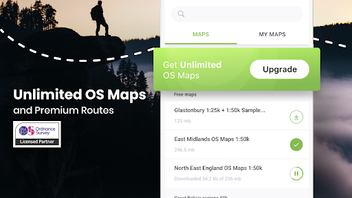
ORDNANCE SURVEY MAPS
• Download any Landranger 1:50k, Explorer 1:25k Ordnance Survey maps (PRO)
• Super fast map display, regardless of signal
POWERFUL GPS FUNCTIONS
• Fully functioning GPS at a fraction of the cost of a dedicated GPS device
• Finds your location in seconds- accurate to within 10 metres
• Create a route, with distance markers, by tapping it out on the screen
• Follow a planned route using the in-built compass & clear direction view
• Hands Free mode (for following a route while cycling)
• Create and Share 'My Places' list (favourite pub, picnic area, great view etc)
• 250,000 points of interest included (with fast search tool)
WEBSITE & ONLINE COMMUNITY (100,000+ MEMBERS)
• Do all your planning (or post trip analysis) with OS maps.
• Plan, edit and share your routes (via Email, Twitter or Facebook).
You can subscribe to unlimited OS maps with OutDoors PRO. Your yearly subscription will be £30 from the date of subscription and will automatically renew unless cancelled at least 24 hours before the end of the current period. Auto-renew can be turned off anytime after purchase. No cancellation of the current subscription is allowed during active subscription period. Also access OS maps on our website: http://outdoorsgps.com
Note: Continued use of GPS running in the background can dramatically decrease battery life.
Terms of Use: http://outdoorsgps.com/terms
Privacy Policy: http://outdoorsgps.com/privacy
What's New
In-app purchases
$1.99 - $38.99 per item
Version Information
- Version
- 5.1.1
- Downloads
- 100K+
- Updated on
- Aug 27, 2025
- Released
- May 20, 2014
- Requires
- Android 5.0
Statistics
Google Play Rating History
Rating Distribution
Downloads Over Time
OutDoors GPS - Offline OS maps has been downloaded times. Over the past 30 days, it averaged downloads per day.
Shaded area shows 30-day prediction based on historical trends
Historical data collection started recently. More data points will be available over time.
OutDoors GPS - Offline OS maps - Google Play Rankings
Top Rankings
| Rank | Country | Category | List | Change |
|---|---|---|---|---|
| — |
Ranking History in
No ranking data available yet. Rankings are updated daily.
#16 in Top Grossing Travel And Local in United Kingdom
 been: track visited countries
OutDoors GPS - Offline OS maps
been: track visited countries
OutDoors GPS - Offline OS maps
 Flight Tracker-Live Air Radar
OutDoors GPS - Offline OS maps users say on Google Play
 Jan Fielden
My confidence in this App has been fully restored. I recently had very slow map download problems but Outdoors Support Team immediately solved the problem, which turned out to be my own fault. I was trying to download to a slow SD card. On replacing the card with a high speed one, my maps downloaded very quickly and everything works perfectly now.
 David Rumney
Avoid this app. Along with many others here I've change phone and can no longer download the OS maps I've paid for. It starts to download a few mb then hangs.
 Rebekah Wilkinson
Good app for walking. Easy to use and doesn't drain the battery too much when out. Used to be better in that you could buy the OS map for individual counties/national parks but now you have to subscribe to get access to those. I've still got the ones I bought a few years ago but can't add any more without subscription. And improvement would be the shared routes from the community - you can't see them on the map before downloading so adding that functionality would help.
 Neil Purnell
Potential to be excellent but simply doesn't work as described. Works great whilst you've got a data signal but sold as being able to download maps for offline use. Maps will not download, so if you're thinking of going off the beaten track (no data signal) be prepared to get lost. Problem has been about for a long time. I don't think it should be available to install until the problem is resolved and I'm surprised Google Play Store allow it to be available.
 Joel S
So am I to assume that this app is now dead, and the money I have spent on offline maps is lost for ever? It used to be very good, but is now completely unusable, even with the "trick" of removing the external storage and installing maps on built-in memory. It can't be that hard to fix, but I'm guessing that all dev work has stopped on this. Such a shame, not just because of the money I've wasted, but it was excellent, with the web version as well for planning routes.
ApkTrusted Ratings & Reviews
Similar Apps

Outdooractive. Hike and Ride
Free

Trailforks
Free

HiiKER: The Offline Hiking app
Free

SIGMA RIDE
Free

calimoto — Motorcycle GPS
Free

Footpath Route Planner
Free

BaseMap: Hunting Maps and GPS
Free

FarOut
Free

bergfex: Hiking & Tracking
Free

Trails Offroad: Offline Maps
Free

Gaia GPS: Offline Trail Maps
Free

5K parkrunner results
Free

Map My Walk: Walking Tracker
Free

Campy - Camper Van Europe
Free

Mapy.com: Offline hiking maps
Free

KOA Camping | RV, Cabin & Tent
Free
Scan this QR code to download

Forwarding you to the page at Google Play market in seconds...
Open Google Play market now