
Footpath Route Planner v2.3.2
Half Mile Labs LLC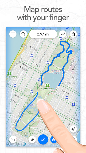


About this app
Developer Description
Running, Hiking, Bike Map - Draw routes with your finger and navigate with GPS
Mix up your routine and plan out a new running route or bike ride, or plan a scenic road trip or multi-day hiking adventure. Footpath allows you to plan custom routes quicker and easier than ever before.
Join millions of adventurers using Footpath Route Planner and pave your own path.
Snap to map
Quickly measure distances by tracing a map with your finger. Footpath will snap to any roads, bike paths, hiking trails, or paths you can find on Footpath's topo maps. Footpath can even snap to rivers and railroads.
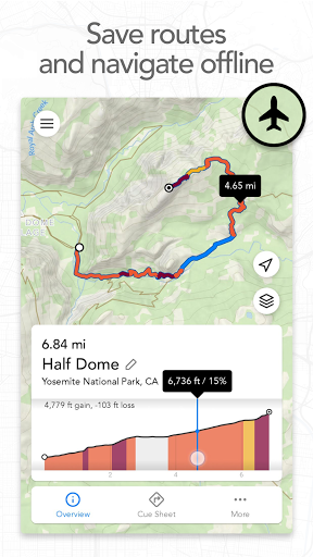
Measure distance and elevation
Know exactly how far and how high you'll travel with an accurate distance measure and detailed elevation profiles. Plan a precise route that matches your mileage goal, or use as a GPS distance tracker if you run without a plan.
Save routes for later
Marathon training or planning a backpacking trip? Sign up for a free account to save up to 5 routes at a time, or save an unlimited number of routes with Footpath Elite.
GPX viewer
Find a cool hiking trail on the web? Import GPX files from anywhere to analyze or save for later.
Share routes
Send your routes to friends or workout partners and let them partake in your adventure.
Footpath is designed to work in any country, and for any activity or adventure you can imagine:
• Running, walking, and hiking
• Cycling and mountain biking
• Motorcycling and driving
• Kayaking, canoeing, and standup paddleboarding
• Backcountry skiing
• Sailing
• And many more!
———
Footpath Elite
Ready to go the extra mile? Upgrading to a Footpath Elite subscription unlocks the following powerful features:
• Turn-by-turn navigation: Footpath will tell you when to turn with turn-by-turn audio cues
• Premium topo maps & overlays: including USGS Topo Maps, OpenCycleMap, bike paths, avalanche slope shading, elevation contour lines, and many more
• Offline map downloads: follow your route even without cell service
• Organize: save unlimited routes and sort routes into custom lists
• Export: export GPX files directly to Garmin Connect, Wahoo ELEMNT, COROS, and other apps
• GPS Devices: export TCX and FIT courses for turn-by-turn navigation on select Garmin and Wahoo running watches and cycling computers
———
Tips for mapping routes
• For a longer route, try zooming in and mapping your route in multiple segments.
• Tap and hold the map to quickly route between waypoints and POIs.
• Did Footpath snap to the wrong roads? Trace over the incorrect segment to edit, or use the eraser tool.
• Turn off snap to roads (magnet icon) and zoom in to manually trace the map. (Try switching to a satellite layer).
———
Contact Us
We've got a lot planned for Footpath. If you have any suggestions or feedback, or if you run into any issues, please contact us at support@footpathapp.com.
What's New
- Public transit map overlay (Footpath Elite)
- Bug fixes
If you're enjoying Footpath, please help us out by writing a review on the Play Store.
If you have any problems or suggestions, send us an email at support@footpathapp.com.
In-app purchases
$1.99 - $23.49 per item
Version Information
- Version
- 2.3.2
- Downloads
- 1M+
- Updated on
- Feb 13, 2025
- Released
- Sep 29, 2020
- Requires
- Android 8.0
Statistics
Google Play Rating History
Rating Distribution
Downloads Over Time
Footpath Route Planner has been downloaded times. Over the past 30 days, it averaged downloads per day.
Shaded area shows 30-day prediction based on historical trends
Historical data collection started recently. More data points will be available over time.
Footpath Route Planner - Google Play Rankings
Top Rankings
| Rank | Country | Category | List | Change |
|---|---|---|---|---|
| — |
Ranking History in
No ranking data available yet. Rankings are updated daily.
#22 in Top Grossing Maps And Navigation in United Kingdom

#25 in Top Grossing Maps And Navigation in Netherlands


#32 in Top Grossing Maps And Navigation in France

Footpath Route Planner users say on Google Play
 Matt Mills
initial experience is good over a known 20 mile route on the North York Moors. I'm planning to use this instead of my os maps subscription for my upcoming Wainwright's c2c in August however I have a few small reservations: the 24 hr time limit on downloaded os maps is a concern - could do with a better explanation on that as a multi-day hike with no signal could be endex for me! Good job on the turn by turn voice btw, works great offline with Bluetooth headsets. could do with a better home page.
 Christopher Anderson
Dropped a star, as trying to make a route map for walking, half way through the line would not continue down some steps ( but they are marked on the map) , instead the line jumped to a path going in the opposite direction, then doubled back to the bottom of the steps, a route 3 times longer ,the strange thing is the line has gone down steps on other maps I've made . Overall a good App.
 Mr. Fill
bit buggy but works ok
 Matthias Jansen
I used to love this app, however, the swedish topo maps are broken and have been broken for quite some time now. An issue I have reported and not even received a reply for. Considering that this is a/the feature I am paying for I should maybe not be as generous as giving two stars.
 p s
p s
no use unless you pay
ApkTrusted Ratings & Reviews
Similar Apps
Map My Walk: Walking Tracker
Free
Map My Run GPS Running Tracker
Free

Cyclers: Bike Navigation & Map
Free

HiiKER: The Offline Hiking app
Free

Gaia GPS: Offline Trail Maps
Free

Ride with GPS: Bike Navigation
Free
Bikemap: Cycling Tracker & GPS
Free

FarOut
Free
Hikingbook: Hike, Bike & Run
Free

Sports Tracker: Run Bike Hike
Free
Map My Ride With GPS Tracker
Free

Relive: Run, Ride, Hike & more
Free
Geo Tracker - GPS tracker
Free

Multi-Stop Route Planner
Free

Outdooractive. Hike and Ride
Free

Avenza Maps: Offline Mapping
Free
Scan this QR code to download

Forwarding you to the page at Google Play market in seconds...
Open Google Play market now