
GPS Camera: Tracking Earth Map v1.0.7
AZ Team Publisher


About this app
Developer Description
GPS Camera for geotagging your images, adding GPS location and date time stamps
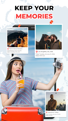
🌍 Capture your memories with the perfect combination of GPS and photography. GPS Map Camera is the ultimate tool for adding GPS coordinates, location data, and an interactive map to your photos and videos. Whether you're a traveler, photographer, or adventurer, GPS Map Camera ensures every photo is tagged with precise location data.
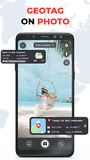
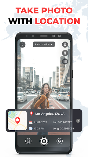
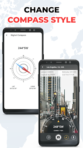
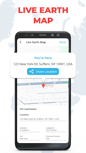
📍 With GPS Map Camera, every photo you take is automatically tagged with GPS coordinates latitude, altitude, and even an interactive map showing where the photo was captured. Perfect for outdoor activities, vacations, or documenting your travel experiences, this app helps keep your location memories organized.
Key Features:
➤ Real-Time GPS Geotagging: Instantly add GPS coordinates to your photos. Never forget where your photo was taken with real-time geotagging.🗺️
➤ Map Overlay: GPS Map Camera automatically adds a map showing the exact location of your photo. Whether you're traveling or exploring local spots, the map overlay makes your geotagged photos more informative.
➤ Altitude Tracking: Capture altitude details along with your GPS coordinates, perfect for documenting outdoor activities like hiking, mountain biking, or camping.🏔️
➤ Custom Watermarks: Add location watermarks to your photos, displaying GPS coordinates and an interactive map.💧
➤ Perfect for Outdoor Adventures: Whether you're hiking, biking, or exploring new places, GPS Map Camera tags your photos with accurate GPS data and a map overlay.
➤ Fast and Efficient: Quickly take geotagged photos without many steps. Enjoy reliable location-based photography.⚡
➤ Instant Sharing: Share your geotagged photos on social media like Instagram, Facebook, or Twitter, showing exactly where your photos were taken.📲
Who Can Benefit from GPS Map Camera?
➤ Travelers & Tourists: Whether you're exploring new cities or traveling abroad, GPS Map Camera tags your photos with location data, making it easy to share your travel experiences.✈️
➤ Photographers & Influencers: Enhance your photo sharing by tagging your photos with precise location data, so your audience can see exactly where the shots were taken.📸
➤ Outdoor Enthusiasts: Whether you're hiking, camping, or cycling, GPS Map Camera adds GPS coordinates and a map overlay to your outdoor photos.🏞️
➤ Business Professionals: Easily document projects or track locations for work with geotagged photos.💼
Why Choose GPS Map Camera?
🌍 In today's world, knowing where you took each photo is essential. GPS Map Camera combines GPS with photography, automatically adding location data and an interactive map to your photos. Whether you're traveling, exploring new locations, or sharing your outdoor adventures, GPS Map Camera helps you keep your memories organized with accurate location information.
📸 Start using GPS Map Camera today and capture your experiences with the most precise location-based photography available. Whether you're a traveler, photographer, real estate agent, or outdoor enthusiast, GPS Map Camera is the perfect tool for geotagging photos and tracking your memories.
What's New
Reduce Ads!
GPS Camera & Tracking Map: Geotag Photos & Location on Pictures
Easily capture and tag your moments with the ultimate geotagging app! GPS Tracking Map lets you add real-time location, date, time, and map coordinates to your photos, making it perfect for travelers, professionals, and photography enthusiasts.
Version Information
- Version
- 1.0.7
- Downloads
- 100K+
- Updated on
- Aug 4, 2025
- Released
- Feb 2, 2025
- Requires
- Android 11
Statistics
Google Play Rating History
Rating Distribution
Downloads Over Time
GPS Camera: Tracking Earth Map has been downloaded times. Over the past 30 days, it averaged downloads per day.
Shaded area shows 30-day prediction based on historical trends
Historical data collection started recently. More data points will be available over time.
GPS Camera: Tracking Earth Map users say on Google Play
 Francis cellar Liad
I hope it's true.
ApkTrusted Ratings & Reviews
More from AZ Team Publisher
See more apps
PDF Viewer App - PDF Reader
Free

Learn Piano - Real Keyboard
Free

Change Color Phone Flash Theme
Free
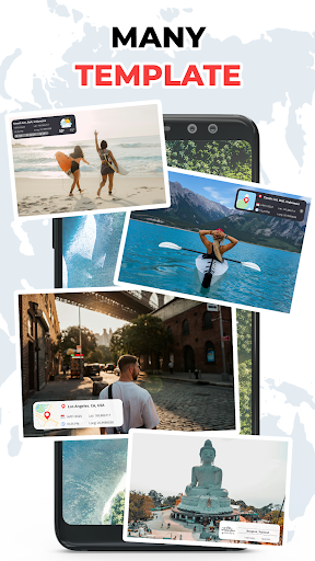
Photo Video Maker Template
Free

QR Code Reader & Scanner App
Free

Beat Master: Music Show Game
Free
Reverse video & Audio Reverse
Free

Funny Insect Prank Filter Game
Free

AR Trend - Funny Challenge
Free
Number Locator: Phone Locator
Free

Speaker Cleaner: Dust Removal
Free

Pro Beat Maker - Drum Pad
Free

LED Battery Charging Animation
Free

Volume Booster: Sound Booster
Free

Spin Wheel: Random Generator
Free

Fluid Screen Reverse Wallpaper
Free
Scan this QR code to download

Forwarding you to the page at Google Play market in seconds...
Open Google Play market now