GPS Map Camera & Navigation v2.0.9
RACCOON TECH


About this app
Developer Description
GPS Map Navigation - Photo Timestamp Camera app to geotag photo & get directions
GPS Map Camera & Navigation app lets you capture geotagged photos with the GPS camera and timestamp camera, add map locations using the map camera, and follow routes with built-in GPS navigation tools. GPS Map Camera is designed for anyone who needs to add locations on photos, add timestamps, explore areas, or find directions.
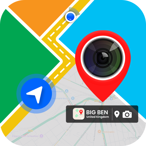
Capture Photos with Location and Timestamp
GPS Camera & Timestamp Camera: Take photos with GPS details like latitude, longitude, altitude, direction, and a visible timestamp. Perfect for travel, work, or daily use.
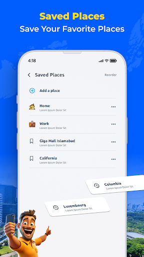
Map Camera: Add map locations on your photos to record where and when each moment happened.
Geotagged Photos and Selfies: Save memories with GPS tags and timestamps using the GPS map camera and timestamp camera.
Location Stamps: Add your current location and timestamp directly to images using the GPS map camera.
Use GPS Map & Navigation for Directions
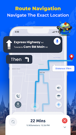
GPS Navigation: Get step-by-step directions with live traffic updates.
Route Planning: Find short with traffic updates for your trip.
My Location: Share your current GPS location with contacts when needed.
Save Parking Location: Save your car’s location and use GPS map navigation to return later.
Extra Tools in the GPS Camera App
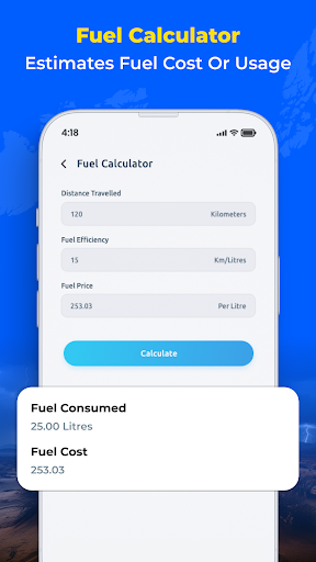
Fuel Calculator: Check fuel costs based on route distance and fuel price.
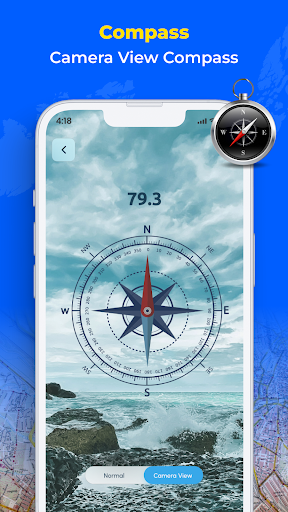
GPS Compass: Use a digital compass to check directions on the go.
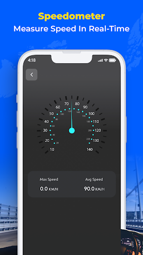
Speedometer: See your current speed while traveling.
Nearby Places: Find restaurants, hospitals, hotels, ATMs, and more.
Location Finder: Locate stations, services, and other important places using the GPS map camera.
Who Can Use This App
Travelers and Bloggers: Use the map camera and timestamp camera to take geotagged and timestamped photos.
Real Estate Agents: Add location info and timestamps to property photos using the GPS camera.
Event Planners: Save photo records with the map camera and timestamp camera.
Hikers and Explorers: Navigate trails and capture images with location and timestamp data.
Daily Drivers: Plan routes, track speed, save parking spots, and document trips with timestamps using GPS map navigation.
Download GPS Map Camera & Navigation App Now
The app works as a GPS map timestamp camera and GPS navigation tool to help you capture photos with locations, times, and travel routes.
In-app purchases
$4.99 - $17.99 per item
Version Information
- Version
- 2.0.9
- Downloads
- 1M+
- Updated on
- Dec 3, 2025
- Released
- Jul 31, 2025
- Requires
- Android 7.0
Statistics
Google Play Rating History
Rating Distribution
Downloads Over Time
GPS Map Camera & Navigation has been downloaded times. Over the past 30 days, it averaged downloads per day.
Shaded area shows 30-day prediction based on historical trends
Historical data collection started recently. More data points will be available over time.
GPS Map Camera & Navigation - Google Play Rankings
Top Rankings
| Rank | Country | Category | List | Change |
|---|---|---|---|---|
| — |
Ranking History in
No ranking data available yet. Rankings are updated daily.
#64 in Top Free Maps And Navigation in United States

#15 in Top Free Maps And Navigation in Argentina

#15 in Top Free Maps And Navigation in Thailand


#21 in Top Free Maps And Navigation in Mexico
 Number Locator- Call Location
GPS Map Camera & Navigation
Number Locator- Call Location
GPS Map Camera & Navigation
 Compass app - Accurate Compass
GPS Map Camera & Navigation users say on Google Play
 Boos Baba
best
 satish kumar
good experience
 desiv 1
The number of ads trying to fake you into installing something is crazy... Avoid this app at all costs.
ApkTrusted Ratings & Reviews
More from RACCOON TECH
See more apps
Music Player - MP3 Player
Free
Photo Recovery: Recover Photos
Free

TV Remote: Control Smart TV
Free

Document Scanner and Reader
Free
Cleanup Space: Storage Cleaner
Free

Ai Photo Editor - Remove BG
Free

Gallery - Album & Photo Vault
Free

Tutor AI: Math Homework Helper
Free

Screen Mirroring, Cast to TV
Free
To Do List - Task Tracker
Free

Soft Voice: AI Text To Speech
Free

VeilNet - VPN Proxy Master
Free
Scan this QR code to download

Forwarding you to the page at Google Play market in seconds...
Open Google Play market now