
Lowrance: app for anglers v2.5.4
Navico Norway AS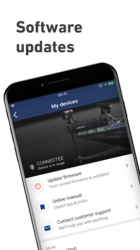


About this app
Developer Description
The Lowrance companion app. Fishing Maps & Trip Planner
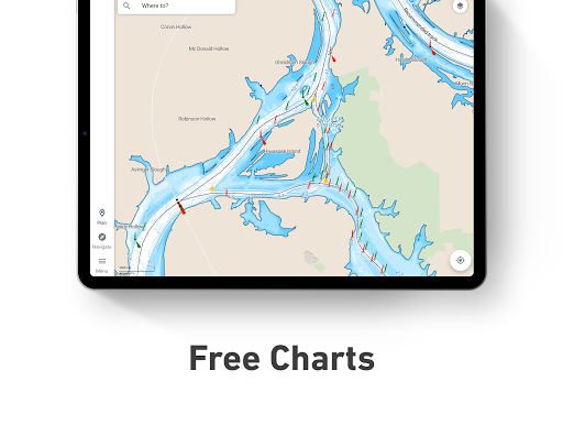
With all the latest and most detailed maps from C-MAP®, the Lowrance App gives you the most accurate charting direct to your mobile device. Now you can manage your favorite waypoints, discover new fishing spots, and plan your next trip with ease. Simply step on-board, sync your data with your Lowrance devices, and spend more time doing what you love – catching fish and logging your favorite spots for future trips.
MANAGE YOUR WAYPOINTS
- Create, store, edit and share your waypoints and fishing spots anytime, anywhere
- Explore new waters and plan great fishing trips in advance
- Offline maps - download your charts and view data, even without mobile coverage or WiFi
DISCOVER NEW FISHING SPOTS AND LAKES
- Latest C-MAP maps - high-resolution bathymetry, custom shading and thousands of Points of Interest, including ramps and fuel
- Autorouting™ - set the best routes to your favorite fishing waypoints automatically
SYNC EASILY WITH YOUR DEVICE
- Save your waypoints, fishing spots, and data with your Lowrance devices when you step on-board, giving you more time to concentrate on catching fish!
- Set Anchor Alerts and notifications for moving outside set locations
REVIEW YOUR DATA
- Sync your App and Lowrance device anytime, on- or off-the-water, so you can always take your latest fishing trip data with you.
The Lowrance App Includes:
- Activation and Registration of your Lowrance Chartplotter
- FREE C-MAP Chart Viewer
- Autorouting™ – find the best route to your favourite places
- Personal Waypoints
- Track Recording
- Thousands of pre-loaded Points of Interest, including relevant information about marinas, harbours, beaches, shops and much more
- Marine Weather Forecast
- Weather Along the Route
- Weather Overlay
- Chart Personalisation
- Import & Export GPX Files – share your Routes, Tracks or Waypoints with friends
- Measure Distance Tool
Upgrade to Premium to unlock additional features, including:
- Full GPS Functionality
- Offline Map Downloads
- REVEAL Shaded Relief
- High-Resolution Bathymetry
- Custom Depth Shading
- AIS & C-MAP Traffic
Try before you buy… Experience the Lowrance App Premium for yourself, with a free 14-day trial (3-day trial in Denmark and Sweden).
Functionality involving direct integration with devices requires NOS software versions of 20.0 and above. Please check for compatibility with your device model:
Elite ti2
Elite FS
HDS Carbon
HDS Live
HDS Pro
The Lowrance App updates on a continuous basis to make sure you get a great experience and enjoy the most up-to-date fishing maps and functionalities. Be sure to check for updates regularly.
Privacy policy
https://appchart.lowrance.com/privacy.html
Terms of service
https://appchart.lowrance.com/tos.html
What's New
In-app purchases
$14.99 - $89.99 per item
Version Information
- Version
- 2.5.4
- Downloads
- 100K+
- Updated on
- Sep 12, 2025
- Released
- Nov 21, 2019
- Requires
- Android 10
Statistics
Google Play Rating History
Rating Distribution
Downloads Over Time
Lowrance: app for anglers has been downloaded times. Over the past 30 days, it averaged downloads per day.
Shaded area shows 30-day prediction based on historical trends
Historical data collection started recently. More data points will be available over time.
Lowrance: app for anglers - Google Play Rankings
Top Rankings
| Rank | Country | Category | List | Change |
|---|---|---|---|---|
| — |
Ranking History in
No ranking data available yet. Rankings are updated daily.
#33 in Top Grossing Maps And Navigation in United States


#5 in Top Grossing Maps And Navigation in Australia


#18 in Top Grossing Maps And Navigation in Spain

#20 in Top Grossing Maps And Navigation in Canada

Lowrance: app for anglers users say on Google Play
 Tony Ford
Great app for reviewing the area you want to fish prior to fishing day. The other helpful feature is the fact if I'm not in my boat, i still have access to my saved spots on a map for reference. I really like the shaded relief view, it definitely helps me decide where I'm running my Charters for that day. The shared vessel info is also cool
 Kevin Nelezen
Very useful for navigation. I wish it had better weather options, but for navigation and way points it works well. It doesn't give water temperature values.
 C G
C G
Lots of cool features, but kinda pointless when the app won't scan the QR code on the unit to register it to the app. There should be another option to join the two. I emailed the app support email provided on the Play Store and got no response.
 Big Tarpon
Seems unfinished. I have the premium version and the waypoint routing routines are pretty awful. Your list of waypoints are automatically numbered but when you look at them on the chart there are no numbers. The whole "simplify route" concept seems half-baked not even sure what they're trying to do. looking at the chart on your phone is about the only thing it can do right.
 Sheldon Abbey
THIS SHOULD BE FREE!! NO point in paying EVEN MORE, when I've spent several thousands of dollars on equipment and maps, now these greedy bastards want you to subscribe to a yearly subscription just to use the features of the "companion app". What a RIPOFF!
ApkTrusted Ratings & Reviews
More from Navico Norway AS
See more apps

Similar Apps

WeFish | Your Fishing Forecast
Free
VesselFinder
Free

Orca: Boat GPS, Charts, Routes
Free
Garmin Dive™
Free

Südtirol Fishing
Free

Wavve Boating: Marine Boat GPS
Free

Holland America Line Navigator
Free
Garmin Jr.™
Free

Bike Route Planner
Paid

Gaggle Paragliding, Ultralight
Free
Garmin Golf
Free
Windfinder Pro: Wind & Weather
Paid

Earth Map App - Live Cam View
Paid
Nautide: Tides, Wind, Waves +
Free

Honge.ai - AI Travel Planner
Paid
Scan this QR code to download

Forwarding you to the page at Google Play market in seconds...
Open Google Play market now