
MarineTraffic - Ship Tracking vVARY
MarineTraffic Applications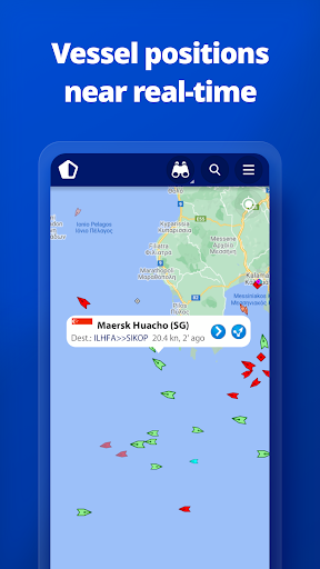


About this app
MarineTraffic - Ship Tracking solves the problem of real-time ship tracking and navigation for professionals and enthusiasts alike, benefiting most those in the maritime industry or with a passion for sailing. Compared to alternatives in the Maps And Navigation category, MarineTraffic stands out with its comprehensive coverage and high user rating, but may fall short in terms of offline capability. The app's excellent rating and large user base are testaments to its effectiveness. With a strong developer reputation and frequent updates, MarineTraffic is a top choice in its category.
Pros
- With over 5 million downloads and a 4.8/5 rating, MarineTraffic boasts an impressive level of social proof and user satisfaction, indicating a well-designed and functional app.
- The app's feature set is comprehensive, providing real-time ship tracking and navigation, making it an invaluable tool for professionals in the maritime industry.
- The developer, MarineTraffic Applications, has a strong reputation and actively updates the app, ensuring it remains relevant and functional.
- The app's accessibility is also a major advantage, with a user-friendly interface that makes it easy for users of all skill levels to navigate and track ships.
- The lack of required permissions is a significant advantage, as it reduces the risk of data collection and privacy concerns.
Cons
- One concern is the app's monetization model, which includes ads and in-app purchases, potentially disrupting the user experience and creating a paywall for certain features.
- Some users may find the app's focus on ship tracking and navigation too narrow, limiting its usefulness for those seeking a more general navigation app.
- The app's requirement for an internet connection to function may be a drawback for users in areas with limited connectivity.
- The presence of ads may also be a concern for users who prefer an ad-free experience.
Best for: The ideal user for MarineTraffic is a professional in the maritime industry, such as a sailor, shipowner, or port operator, or an enthusiast with a strong interest in sailing and navigation, who requires real-time ship tracking and navigation data and is willing to invest time in learning the app's features and functionality.
Developer Description
The world's leading ship tracking app!
Connected to the largest network of land-based AIS receivers, the app covers most major ports and shipping routes.
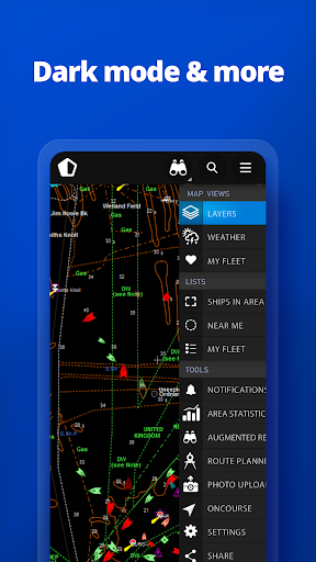
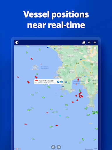
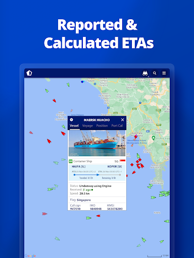
• View VESSELS ON THE LIVE MAP, search for ships, boats and seaports and see what's near you!
• More than 300,000 VESSELS PER DAY report their positions via MarineTraffic AIS
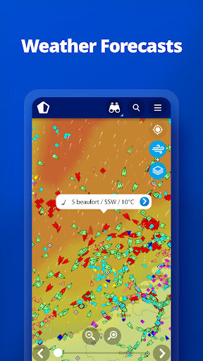
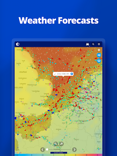
• View live wind and 48-hour WIND FORECASTS on the map
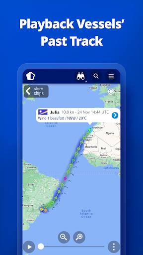
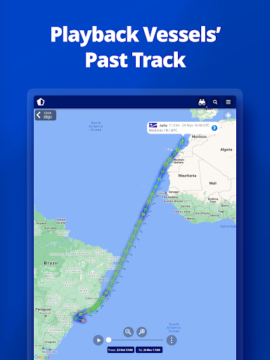
• ANIMATED PLAYBACK of vessel's track
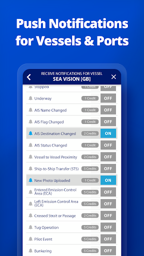
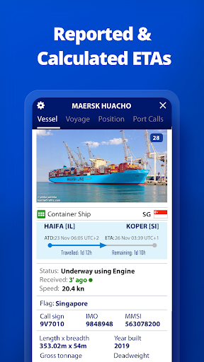
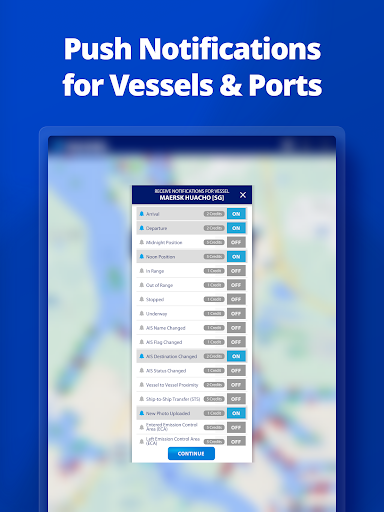
• PORT ARRIVALS & DEPARTURES live for over 4,000 ports and marinas, current conditions in ports and estimated time of arrival for the boats & ships.
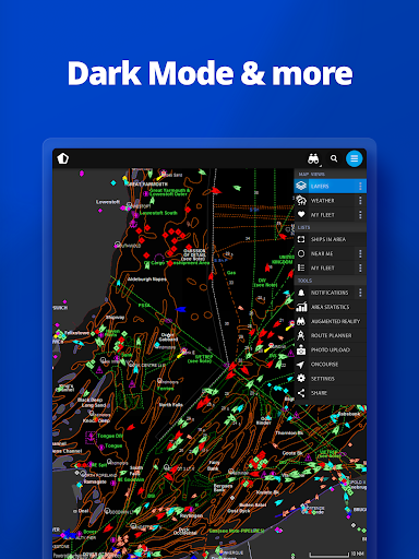
• Manage your list of vessels ("MY FLEET"), shared with all your devices and MarineTraffic.com
• Browse 4,5 MILLION PHOTOS of ships, harbours, lighthouses and much more!
• Identify and track vessels sailing beyond the range of land-based AIS receiving stations, using satellite tracking, with ACCESS PLUS 24 (in-app purchase)
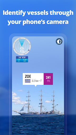
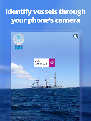
• Identify vessels around you at a glance with the Augmented Reality tool.
Just point your device's camera to the horizon and get all the information you need about the vessels in your area: name, flag, speed, distance from you and a lot more.
Also, for MarineTraffic paying subscribers:
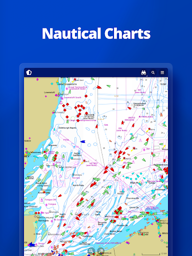
• NAUTICAL CHARTS
• ADVANCED WEATHER MAPS
• ADVANCED DENSITY MAPS
• SAT-AIS DATA
Join the great MarineTraffic community!
** If you're only interested in a specific area, please confirm coverage on www.marinetraffic.com before purchasing the app **
Privacy
Given the app's lack of required permissions, it appears to be a relatively safe choice in terms of data collection and privacy concerns. However, users should still be cautious when using the app's in-app purchase feature and ensure they understand what data may be collected. To minimize potential risks, users should review the app's terms and conditions and only provide necessary information.
Tips
To get the most out of MarineTraffic, users should take the time to explore the app's various features and settings, including the ability to filter and customize ship tracking data. Additionally, users can optimize performance by ensuring their device has a stable internet connection and closing other resource-intensive apps. For first-time users, it's recommended to start with the app's tutorial or guide to understand the full range of its capabilities.
What's New
In-app purchases
$0.99 - $94.99 per item
Version Information
- Version
- -
- Downloads
- 5M+
- Updated on
- Dec 9, 2025
- Released
- Dec 18, 2012
- Requires
- Android 7.0
Statistics
Google Play Rating History
Rating Distribution
Downloads Over Time
MarineTraffic - Ship Tracking has been downloaded times. Over the past 30 days, it averaged downloads per day.
Shaded area shows 30-day prediction based on historical trends
Historical data collection started recently. More data points will be available over time.
MarineTraffic - Ship Tracking - Google Play Rankings
Top Rankings
| Rank | Country | Category | List | Change |
|---|---|---|---|---|
| — |
Ranking History in
No ranking data available yet. Rankings are updated daily.
#32 in Top Grossing Maps And Navigation in United States


#81 in Top Free Maps And Navigation in United States


#9 in Top Grossing Maps And Navigation in United Kingdom

#10 in Top Grossing Maps And Navigation in Indonesia


MarineTraffic - Ship Tracking users say on Google Play
 Carolyn Hersh
best app ever for finding ships
 Kenth Forsman
gives you insight while traveling in the water
 shashika Lakshitha
This app is good but some features want by buy. but free options also have
 Wasiu Mubarak
good
ApkTrusted Ratings & Reviews
More from MarineTraffic Applications
See more apps
Similar Apps
Navionics® Boating
Free
ShipAtlas - Ship Tracker
Free

VesselFinder
Free

MarineRadar: Vessel Tracker
Free

Flightradar24 Flight Tracker
Free
Windfinder: Wind & Weather map
Free

Orca: Boat GPS, Charts, Routes
Free

Holland America Line Navigator
Free

Nautide: Tides, Wind, Waves +
Free

Planes Live - Flight Tracker
Free

Compass & Altimeter
Free

Ventusky: Weather & Live Radar
Free

Plane Finder - Flight Tracker
Free

Windy.app - Enhanced forecast
Free

Zoom Earth - Weather Forecast
Free

GPS Essentials
Free
Scan this QR code to download

Forwarding you to the page at Google Play market in seconds...
Open Google Play market now