World atlas & world map MxGeo v9.5.8
HPB Labs


About this app
Developer Description
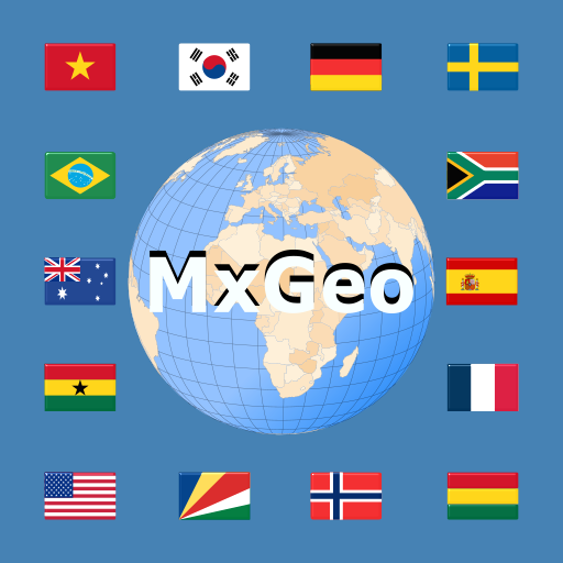
World Atlas and educational app for geography. Maps, flags and country data.
Designed for smartphones and tablets.
• Flags, essential maps and basic data for more than 250 countries and territories of the world
• Search for countries, major cities, rivers, mountains, lakes or coordinates
• Interactive political world and continent maps
• Shaded relief layer for world and continent maps
• Geography quiz challenge for playful learning
• Country comparison, favorites and distance calculator
• Comprehensive maps and data of all African countries
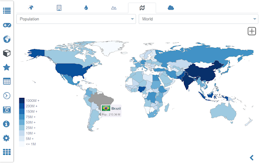
• Choropleth maps: area and population
• World clock and distance calculator
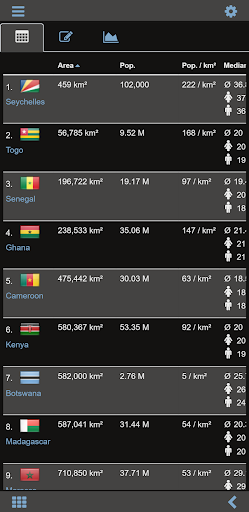
• World-explorer: the smallest, largest, ... countries
• No online connection required
Explore the world by political world and continent maps offline maps. Learn where each country in the world is located. View its position highlighted on a digital globe. Create your favorite color theme or choose from different color schemes for map display.
Do you know the flag of Zambia? Yes? Perfect. Do you also know in which country Mount Kilimanjaro is located? “World atlas & world map MxGeo Free” Quiz helps you acquire a geographic literacy in a playful manner.
Choose from six geo guessing games:
• Test your knowledge about the capitals of Africa
• Do you know the ISO countries codes?
• Recognize the proper country flag based on the outline map
• Do you know the top-level domains of each country?
• Guess the highlighted country on the virtual globe
• Do you know the mountains of Africa?
Geo learning app and educational game which is fun for everyone whether children, adults, seniors or teachers. Get ready for your next stay abroad while enjoying this great world almanac including time zones and statistical data, such as population growth and other key figures. Or prepare for your next geography lesson with this genius digital world map. If not traveling our world atlas lets you explore the world just only virtually.
Free version includes comprehensive data and maps for all African countries. Get “World atlas & world map MxGeo Pro” with detailed data and maps including regional units and capitals for more than 260 countries and territories of the world: Europe, Asia, North America, Africa, Oceania and South America.
What's New
• Bug fixes and improvements
8.x:
• Enhanced chart visualization
• Improved quiz questions choice
• Country comparison and World Explorer new key indicator: population density
• New choropleth map: population density
• Search for countries, major cities, rivers, mountains, lakes and coordinates
• World Explorer: largest cities, longest rivers and highest mountains
Version Information
- Version
- 9.5.8
- Downloads
- 1M+
- Updated on
- Nov 18, 2025
- Released
- May 31, 2015
- Requires
- Android 7.0
Statistics
Google Play Rating History
Rating Distribution
Downloads Over Time
World atlas & world map MxGeo has been downloaded times. Over the past 30 days, it averaged downloads per day.
Shaded area shows 30-day prediction based on historical trends
Historical data collection started recently. More data points will be available over time.
World atlas & world map MxGeo users say on Google Play
 Venom
Venom
It's a great 👍 app, very comprehensive, and easy to navigate , I will get the pro version soon. Samsung s21 ultra Android 14 .
 Enalos Loqia
I won't give it a bad rating since I only used it maybe once or twice, barely checked anything out. I had it for the world map and, to be honest, it isn't all that great imo. You have to pay to see the maps of the past. I don't exactly have a grudge or anything about it, it just happened that I probably needed a map that was more detailed. The UI was a bit clunky too (At least, to me). That's all, have a nice day. (If you who reads this has tinnitus, sup. I do too & it's acting up. It's so loud)
 Bhaskar Das
Dear developer, I have come across this app. Overall app is good. But the map of India is incorrect. You should take action and update it accordingly.
 Mr. Jazz Salcedo
I just didn't like it. I was expecting a bit more.
 Gabriel Morales Gonzalez
You have to have the "pro" version to get all the stats. I believed that this was the whole app, but apparently, there is another app to get all the information. I would rather Google and see all of the Atlas information on the internet.
ApkTrusted Ratings & Reviews
More from HPB Labs
See more apps
Scan this QR code to download

Forwarding you to the page at Google Play market in seconds...
Open Google Play market now