
2GIS: Offline map & navigation vVARY
2GIS


About this app
Developer Description
Offline map, GPS navigation, live traffic, parking, transit routes, and more
With 2GIS’s maps and navigation, you will feel at home even in an unfamiliar place:
— easily find the address, company, phone number, working hours, goods or services;
— find out how to get there by car, bus, subway, or follow the navigator on foot;
— find an entrance to a building and a parking lot nearby.
Accurate maps. Locate districts, buildings, streets, bus stops, subway stations, gas stations, sports grounds, and other objects.
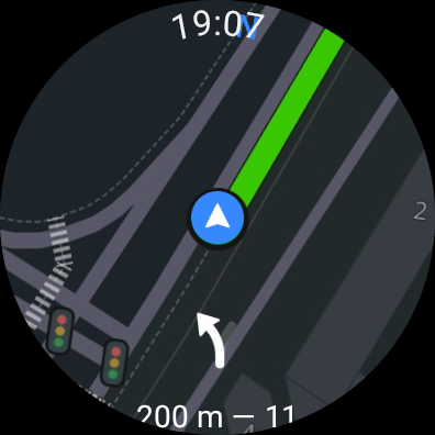
GPS-navigation. Considers real-time traffic jams, signs, speed cameras, toll and unpaved roads, builds routes between cities and through several points. Supports picture-in-picture mode, keeping your route on screen even when the app is minimized. There is also a free app for Android Auto.
Road events. Reports of accidents, blocked streets, and speed cameras, user comments — everything is right on the map.
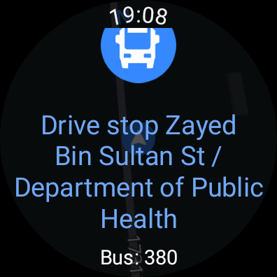
Public transport. 2GIS knows the timetable and online routes of public transit.
Walking routes. Pedestrian navigation paves the way wherever you can go on foot. Works in the background, supports voice guidance.
Navigation for trucks. Cargo navigator gets directions for trucks considering the individual characteristics of vehicles and cargo.
Friends on the map. Now you can find your friends and kids on the map! 2GIS shows the real-time location of your friends. You decide who to add as friends and who will see your location. Manage your visibility in the settings.
Detailed directory. 2GIS shows addresses, entrances, and postal codes. 2GIS knows phone numbers, working hours, social networks, websites, and entrance locations. Users add photos of companies and write reviews.
Travel guide. Find out about the main attractions, places with Wi-Fi, and more on the map.
A 2GIS Notifications companion app for smart watches on Wear OS. A handy tool for navigating routes on foot, by bike or by public transport from the main 2GIS app: view the map, get manoeuver hints and get vibration alerts when approaching a turn or a destination bus stop. The companion starts automatically when you start navigation on your phone. Available for Wear OS 3.0 or later versions.
Everything you need: offline map, navigation, public transport, family locator, and Android Auto support — all in 2GIS.
Available maps:
Cities of the UAE:
Dubai, Sharjah, Abu Dhabi, Al Ain, Ajam, Ras Al Khaimah, Fujairah, Umm Al Quwain, Dibba Al Fujairah, Khor Fakkan, Kalba, Al Salamh, ect.
Cities of Russia:
Moscow, Saint Petersburg, Novosibirsk, Ekaterinburg, Krasnoyarsk, Chelyabinsk, Ufa, Omsk, Kazan, Perm, Nizhny Novgorod, Sheregesh, etc.
Cities of Belarus, Kazakhstan, Uzbekistan, Azerbaijan and Kyrgyzstan:
Minsk, Pavlodar, Semey, Aktau, Aktobe, Almaty, Nur-Sultan, Bishkek, Karaganda, Kokshetau, Kostanay, Osh, Baku, Tashkent, etc.
Support: dev@2gis.com
Version Information
- Version
- -
- Downloads
- 100M+
- Updated on
- -
- Released
- Mar 9, 2011
- Requires
- Android Varies with device
Statistics
Google Play Rating History
Rating Distribution
Downloads Over Time
2GIS: Offline map & navigation has been downloaded times. Over the past 30 days, it averaged downloads per day.
Shaded area shows 30-day prediction based on historical trends
Historical data collection started recently. More data points will be available over time.
2GIS: Offline map & navigation - Google Play Rankings
Top Rankings
| Rank | Country | Category | List | Change |
|---|---|---|---|---|
| — |
Ranking History in
No ranking data available yet. Rankings are updated daily.
#3 in Top Free Maps And Navigation in Russia

2GIS: Offline map & navigation users say on Google Play
 Ranvijay Singh
nice
 Athar Ali
Better than Google Maps exclusive for UAE/Dubai and some places. Works without the Internet, of course you need to download the location first. One issue: Blue arrow classic navigation cursor not available when you are on foot. Please fix this. Please don't reply asking me to write to some email or link, I write feedback here in PlayStore only.
 Mary
Mary
Всегда говорила, что 2гис круче google map. Задумка действительно крутая, но! Последнее время работает просто ОТВРАТИТЕЛЬНО! Подвисает ПОСТОЯННО, не реагирует на прикосновения, на скролллы и т.д. Если бы проблема была в телефоне, то так бы делали все приложения, но так делает ТОЛЬКО 2ГИС!!!
 Alik Talipov
сильно зависает после новогоднего обновление, в режиме общественного транспорта
 Meruyert Temirbekova
can't leave honest reviews about places. negative reviews are erased from this app. so I don't recommend relying on the reviews from this app, better to use others.
ApkTrusted Ratings & Reviews
More from 2GIS
See more apps
Similar Apps

Yandex Maps and Navigator
Free

Yandex Navigator
Free

Яндекс — с Алисой AI
Free

Yandex Music, Books & Podcasts
Free

Mail: Email, Cloud, Calendar
Free

OK: Social Network
Free

Yandex Browser with Protect
Free
Karta GPS Offline Maps Nav
Free

Yandex Weather & Rain Radar
Free

Yandex Start
Free

VK: music, video, messenger
Free

Yandex Metro
Free

MAPS.ME: Offline maps GPS Nav
Free

Yandex Translate
Free

Yandex Mail: Email & Cloud
Free
Save Location GPS
Free
Scan this QR code to download

Forwarding you to the page at Google Play market in seconds...
Open Google Play market now