
2GIS beta vVARY
2GIS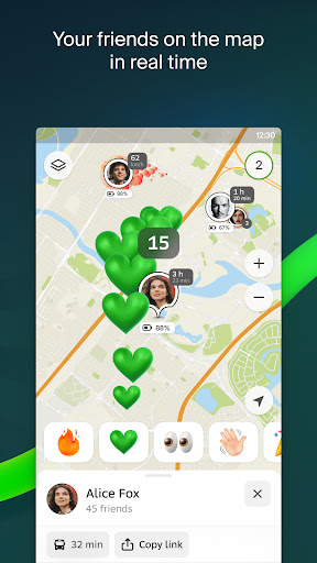


About this app
Developer Description
Beta version: navigation, public transport, place search, and friends on the map
We appreciate your feedback and bug reports. You can send them through the app menu.
There’s no need to delete the main 2GIS app. The beta runs separately, and you can switch between the two at any time.
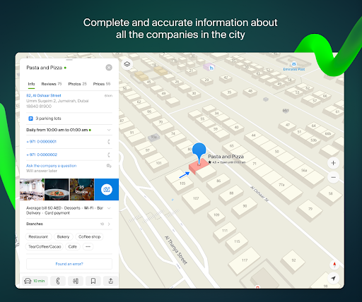
Map, GPS navigator, public transport, guide and directory — all in one app. 2GIS shows your location, helps you find addresses, and builds routes for cars, public transport, bicycles, or walking. You can even see your friends' live location right on the map using the GPS-tracker feature "Friends on the Map".
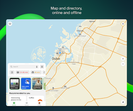
The app is free and works both online and offline. Just download the city or region you need and use the free offline maps and navigation anytime — ideal for travelling or when there's no connection.
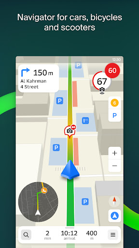
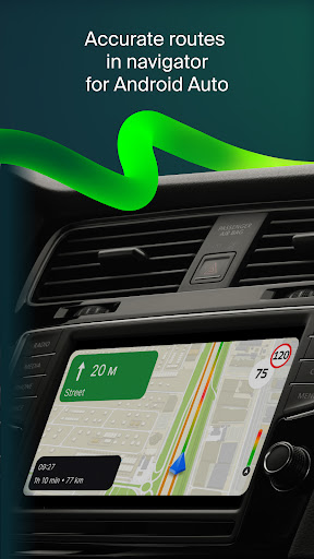
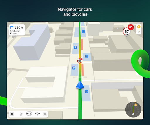
Powerful GPS navigator with Android Auto support. Detailed roads with tunnels and interchanges in 3D. The route accounts for traffic, accidents, and construction. You’ll also get speedcam alerts, helping you check speed of the vehicle and avoid fines. Built-in anti-radar features add extra safety on the road. Looking for parking? The app shows nearby parking lots and guides you right to them or to the building entrance. It even supports Android Auto, making it a smart choice for any car driver.
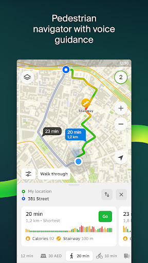
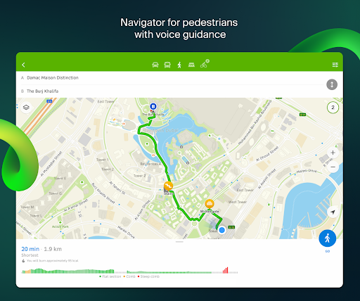
Cyclists, scooter riders, and pedestrians will appreciate smart route planning that takes into account slopes, stairs, bike lanes, and even footpaths. Whether you're on a scooter or walking, 2GIS helps you navigate the city safely and efficiently.
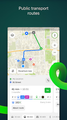
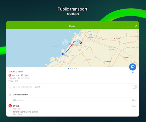
2GIS provides full-featured navigation for public transport. Plan routes by bus, subway, tram, trolleybus, or commuter train. Choose the fastest or most convenient option — with or without transfers. Vehicles are shown on the map in real time, and up-to-date schedules, including autobus and train timetables.
Stay connected with Friends on the Map. Add your friends and family members as Friends in 2GIS to share live location and see each other on the map in real time! No need to ask, “Where are you?”, just check the exact location. It makes meeting planning easier (especially if someone is running late) or allows for spontaneous meetings! Send an emoji to a friend to offer a meeting or start conversation in chat without needing to switch to a messenger.
You can share a link to your location or route with anyone — not just those on your friends list. Or create temporary travel groups and control who has access to your location tracking. It's a private and flexible way to stay in touch during trips or daily life.
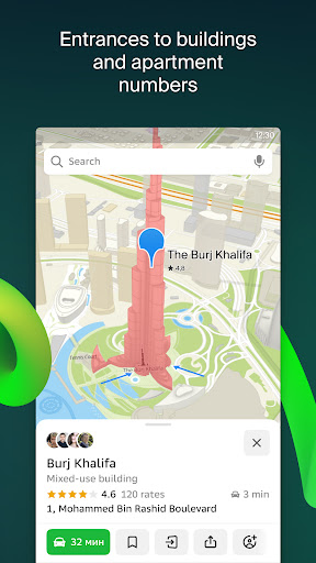
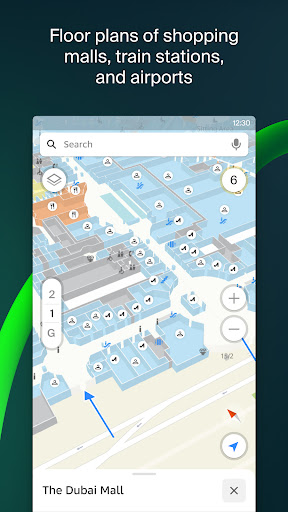
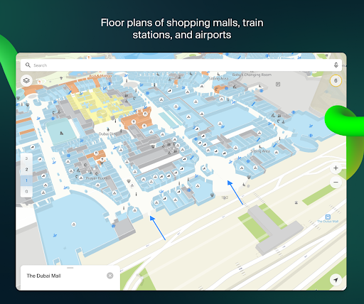
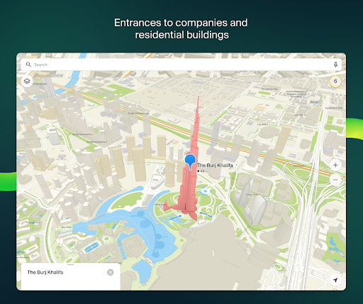
Maps maxed out. Detailed maps with realistic models of buildings, neighborhoods, roads, bus stops – even trees in a park and entrances to buildings are shown! Floor-by-floor layouts and indoor offline navigation are available for malls, train stations, and airports – you won't get lost! As well as layers with real estate, car sharing and other useful services.
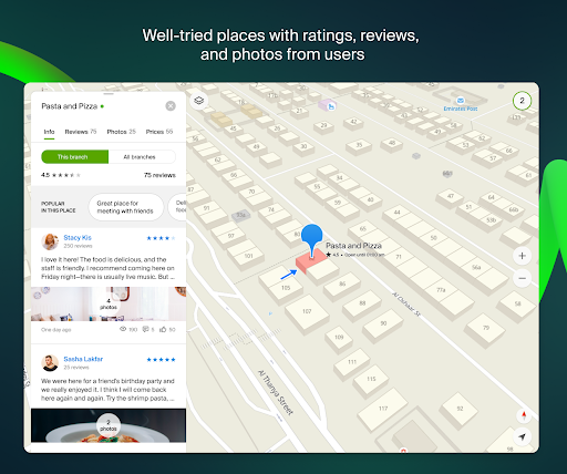
Guidebooks. No need to get your guide separately — 2GIS combines navigation with local discovery in one app. Discover interesting places for a great travel experience in any city! Includes original selections, audio guides and sightseeing attractions in 3D.
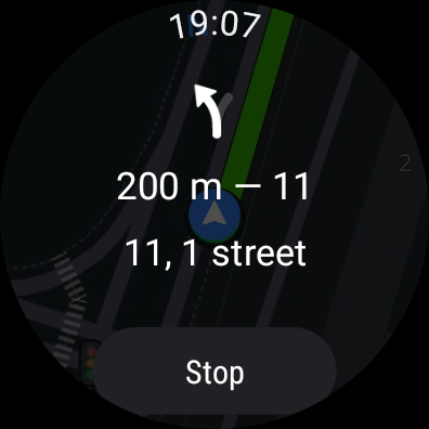
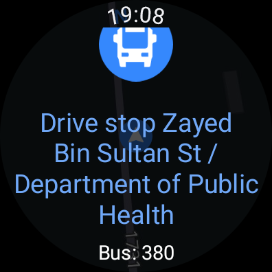
A 2GIS Notifications companion app for smart watches on Wear OS. A handy tool for navigating routes on foot, by bike or by public transport from the main 2GIS app: view the map, get manoeuver hints and get vibration alerts when approaching a turn or a destination bus stop. The companion starts automatically when you start navigation on your phone. Available for Wear OS 3.0 or later versions.
Support: dev@2gis.com
What's New
— Friends on the Mini-map: see where your favourite people are while cruising with car or motorcycle navigation.
Version Information
- Version
- -
- Downloads
- 5M+
- Updated on
- Dec 24, 2025
- Released
- Oct 13, 2020
- Requires
- Android Varies with device
Statistics
Google Play Rating History
Rating Distribution
Downloads Over Time
2GIS beta has been downloaded times. Over the past 30 days, it averaged downloads per day.
Shaded area shows 30-day prediction based on historical trends
Historical data collection started recently. More data points will be available over time.
2GIS beta - Google Play Rankings
Top Rankings
| Rank | Country | Category | List | Change |
|---|---|---|---|---|
| — |
Ranking History in
No ranking data available yet. Rankings are updated daily.
#19 in Top Free Maps And Navigation in Russia


2GIS beta users say on Google Play
 Annelibeth Oliveros
Navigator is excellent. Shows the exact place I am looking for. It is an added feature to capture photos and write ups about the place, it invites me more to travel and explore. This and more are provided by the app, definitely perfect not just for Dora but to all the keepers of wanderlust🤩
 manju nath
This app needs updates for Australia..this apps faster, love the design and user frendly
 Umair Khan
why it consume too much data? else overall well just consuming a lot mbs
 Lina Y
Not very functional similar to Google maps prefer Google maps
 M Nawaz
⚠️ 2GIS App – A Big Problem for Dubai Riders! 😡 I’m a rider in Dubai, and I’ve been using 2GIS for daily deliveries. But now this app has become nothing less than a data-eating monster! It consumes around 3.4GB in just 12 hours — that’s insane! 😤 Riders are already struggling with fuel and internet costs, and 2GIS just made things worse. It keeps running in the background, drains data nonstop, slows down the phone, and even causes overheating. In a city like Dubai, where internet is expensive
ApkTrusted Ratings & Reviews
More from 2GIS
See more apps
Similar Apps

Yandex Navigator
Free

Yandex Maps and Navigator
Free
Karta GPS Offline Maps Nav
Free

Yandex Metro
Free

Mail: Email, Cloud, Calendar
Free

Yandex Mail: Email & Cloud
Free

Yandex Disk – Cloud Storage
Free

Uklon - More Than a Taxi
Free
Save Location GPS
Free

Yandex Weather & Rain Radar
Free

My Track
Free

OK: Social Network
Free

Uklon Driver
Free

Яндекс — с Алисой AI
Free
Sygic GPS Navigation & Maps
Free

MAPS.ME: Offline maps GPS Nav
Free
Scan this QR code to download

Forwarding you to the page at Google Play market in seconds...
Open Google Play market now