
Delta Altitude v2.16
Disciple Skies Software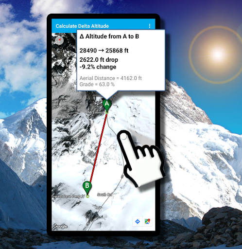


About this app
Developer Description
Get the altitude difference between any two points worldwide.
Don't guess how high you climbed: Know how high you climbed with Delta Altitude: The leading height difference calculator!
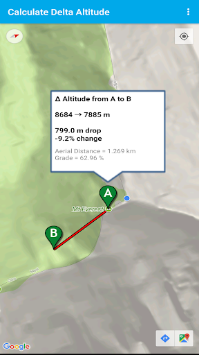
Delta Altitude is an elevation calculator that allows you to get the altitude at any point or the change in elevation between two points simply by tapping on a map.
What is the difference in height between your base camp and Mount Everest's Peak?
Tap on your base camp, then tap on Everest's peak and get your answer, instantly.
The application accesses altitude databases that are built from numerous sources of altitude data obtained using satellite and aircraft LIDAR (Laser Light Detection and Ranging) and NASA's Shuttle Radar Topography Mission.
How accurate is this app?
The horizontal resolution of the LIDAR scans is as fine as 1 meter or less while NASA's Radar scans are available at a resolution of 30 meters. So, the accuracy will vary depending on the type of scan that is available for your area or the area you select.
The most accurate values will be obtained in the United States where LIDAR scanning has been used extensively.
In general, altitude values should be accurate to 5 meters or better.
What's New
In-app purchases
$2.49 per item
Version Information
- Version
- 2.16
- Downloads
- 50K+
- Updated on
- Dec 1, 2025
- Released
- Apr 9, 2013
- Requires
- Android 6.0
Statistics
Google Play Rating History
Rating Distribution
Downloads Over Time
Delta Altitude has been downloaded times. Over the past 30 days, it averaged downloads per day.
Shaded area shows 30-day prediction based on historical trends
Historical data collection started recently. More data points will be available over time.
Delta Altitude users say on Google Play
 A Google user
Stop working properly on Lollipop. All it says now is "cant get altitude please check your connection" Version 2 has corrected problem now OK. Thanks Dev.
 Chris Auerswald
This is an awesome APP. But it needs to up date the airial layout even though I bought this product....
A Google user
Better retry that version 2 fix. Just says it doesn't have connection. Won't be paying money for a message like that. S8+.
 ganesh 7hills stereo
Doesn't work at all.
ApkTrusted Ratings & Reviews
More from Disciple Skies Software
See more apps
Walking Odometer Pro
Free

GPS Waypoints Navigator | MAPS
Paid

Polaris GPS Hike, Bike, Marine
Free

Bible Horoscopes
Free
DS Speedometer & Odometer
Free

DS Compass
Free
Altimeter & Altitude Widget
Free

Bible Trivia Wheel - Quiz Game
Free
DS Barometer & Altimeter
Free

Find My Car - GPS Navigation
Free
Trailblazer Navigator Pro
Free

Morse Code Telegraph Keyer
Free
DS Hygrometer -Humidity Reader
Free

Sun and Moon
Free
Land Calculator: Map Measure
Free
Real Mercury Thermometer
Free
Scan this QR code to download

Forwarding you to the page at Google Play market in seconds...
Open Google Play market now