Boat Beacon - AIS Navigation v2.81
Electric Pocket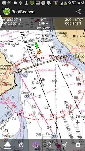

About this app
Developer Description
GPS Marine Navigation with AIS Collision Detection using just your phone.
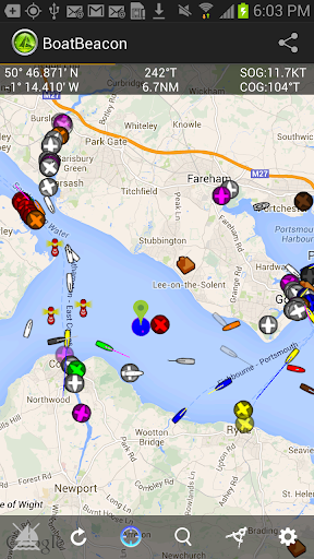
Boat Beacon is the only Marine AIS ship tracking app to provide Collision Detection, use real-time data and share your own boat’s position with other internet AIS users.
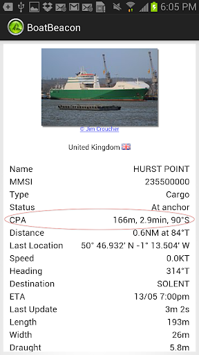
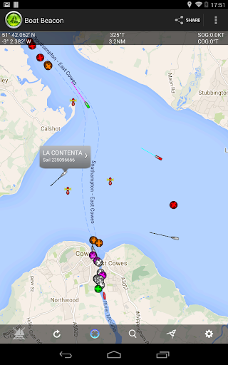
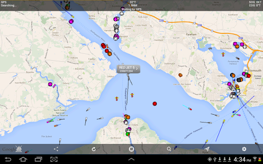
Specifically designed for use on the water, as well as showing all the Ships around you on a chart, Boat Beacon uniquely provides Bearing, Range and Closest Point of Approach (CPA) calculations in addition to AIS ship information. Transmits as well as receives internet AIS and is the only app that continuously monitors CPA, notifying if potential collisions are detected even when the app is in the background.
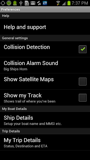
Key Features
------------
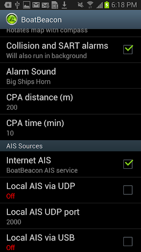
Receives and sends AIS ship data in real-time via the internet. No VHF AIS receiver, transponder or aerial required.
Over the horizon Collision and SART detection (30 miles radius) using continuous Closest Point of Approach (CPA) calculations - highlights boats that are on a potential collision course and alarms even when the app is in the background.
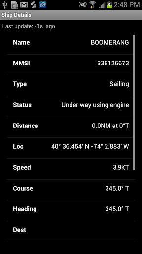
Provides Bearing and Distance information to other boats in addition to AIS information like speed, course, location, name, length etc. Shows you a track of the boats most recent voyage.
Share your live position, speed course and destination. People can follow you using Boat Beacon or our free Boat Watch app and on leading internet AIS systems like MarineTraffic and Ship Finder. Transmit also works continuously in the background when enabled.
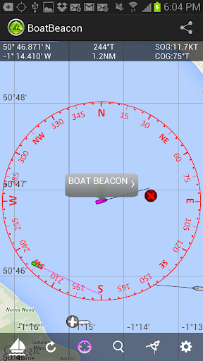
Live Map view with compass overlay which rotates with you so you can look in the direction of the ships on the map to locate them. You can also tilt the map to get a 3D perspective by dragging upwards with two fingers.
NOAA US and UKHO Marine Charts (IAP required)
Extensive details on other ships including Photos.
Search for boats or places by name or MMSI.
Share your track and position with friends and family instantly and in real time via email, Twitter and Facebook etc.
AIS Share lets you share BoatBeacon's live AIS data with other apps like Navionics on your device. (IAP required with free 3 day trial)
Man Overboard (MOB) & Anchor Watch:-
-MOB tracks the position, distance, bearing & time in water.
-Anchor Watch marks your anchor's position & alerts if you drift out of range or too fast (IAP with free 3 day trial).
Arm all the crews in a race with Boat Beacon and see real time updates on the race positions. Watch the action and replay it back in the Club-house with Boat Beacon's dedicated live race web pages.
VHF AIS with RTL-SDR and AIS Share app.
Local NMEA AIS via Wifi and USB.
Boat Beacon requires internet access to work. Most popular coastal areas around the world including the US and UK have mobile data access (2G or better) extending 12 or more miles out to sea.
Requirements:
Android Smartphone or Tablet with GPS.
Internet connection.
You do not need an MMSI to use Boat Beacon and you can be seen on Boat Beacon by other Boat Beacon users without having one. However if you want to be seen on Global AIS systems like Marine Traffic, Ship Finder and AIS Hub, etc. then you will need to have and use an MMSI number. If you don't have an MMSI for your boat you can obtain one in the US by visiting http://www.boatus.com/mmsi (the USCG approved agent). Alternatively email us for a free internet MMSI number.
Please note that continued use of GPS running in the background can dramatically decrease battery life.
AIS Ship data is provided by a network of voluntary AIS shore based stations. Some areas may not have AIS coverage.
N.B. This is not an AIS transponder. You will not be visible to other ships on their AIS systems unless they also use data from the same land based AIS networks.
NOT FOR NAVIGATION
This program is distributed in the hope that it will be useful. Boat Beacon should only be used for basic navigation reference and should not be solely relied upon to determine precise locations, proximity, distance, or direction.
What's New
Fix for layouts in boat and trip details, help and faq on OS15 and above
AIS Sharing via NMEA0183 and NMEA2000 to MFDs like the Garmin, Echomap and Simrad/Lowrance/B&G so they can display live AIS targets without needing an AIS VHF receiver and aerial.
Local AIS receive over UDP working again.
In-app purchases
$3.99 - $32.99 per item
Version Information
- Version
- 2.81
- Downloads
- 10K+
- Updated on
- Sep 19, 2025
- Released
- Aug 2, 2012
- Requires
- Android 5.0
Statistics
Google Play Rating History
Rating Distribution
Downloads Over Time
Boat Beacon - AIS Navigation has been downloaded times. Over the past 30 days, it averaged downloads per day.
Shaded area shows 30-day prediction based on historical trends
Historical data collection started recently. More data points will be available over time.
Boat Beacon - AIS Navigation - Google Play Rankings
Top Rankings
| Rank | Country | Category | List | Change |
|---|---|---|---|---|
| — |
Ranking History in
No ranking data available yet. Rankings are updated daily.
#11 in Top Paid Maps And Navigation in United States
#24 in Top Paid Maps And Navigation in Mexico


#24 in Top Paid Maps And Navigation in India
#24 in Top Paid Maps And Navigation in Saudi Arabia
Boat Beacon - AIS Navigation users say on Google Play
 A Google user
Both the team and the application are great, I have been using it for a year as my ais device on my boat changed mobile device and stopped working as expected, the development team assisted in a very professional manner and helped me find the problem and provided a solution... Free of charge... I can't ask for a better service thank you, all the team, Justin from Gibraltar
A Google user
Add photo of own boat?
 Wendy Pumariono Putro
Ais sharing work, but not as expected. It loss signal few second after AIS connected on navionics. Please advise. Update--Apps can connected but it seems unstable. I can see other boat, but after few second it mark with cross. Any advise to make it stable would be appreciated.
 v p
v p
Hello, I'm new user of the app. I'm enthusiastic by this, by possibility increase safety on small yacht without MMSI! However, I'm usually a bit strict on applications that collect more personal data than necessary. Especially, if the app is payed. Please correct me if I'm wrong. >>> 1, Unlike the User guide in the application, which says about "Location sharing enabling" (in describing "Onboard" button), I couldn't find this switch anywhere. So, If I understand well, the current version DO NOT enable Collision detection without internet transmisting own position to your net, isn't it? >>> 2, If I try switch "Onboard" without PERMANENT use Background location, this function is refused. I understand the philosophy: By single click start all safety functionality. No doubts, no forgotten something, no problems with darked screen. But I'm not a blunt consumer, I'm a responsible sailor! I have a cell phone in my pocket that will discharge in a few hours in a weak signal. And I want to be the one who evaluates myself in places where there is a risk of a collision, such as near a port or a busy waterway - after whole day sailing for example. I want to be the one who decides to share my coordinates, unless the law imposes this obligation. A strong warning when switching off 1, or 2, is fine. But making them completely impossible is unacceptable for me. If these obstacles are insurmountable, I will be disappointed and ask for a refund.
 George Neal
Would not recommend this app at all. Boat position is all over the place, sometimes on land. It then comes back to the water, but not where my boat is. Alert goes off when I am anchored and no nearby boats are moving. Also sends battery alert when my tablet is 87% charged. They tell me it is the gps settings but gps works fine with navionics , Google maps and live ships. Then its extra money to use it with navionics, a yearly fee of A$40. Very unsatisfied customer, a waste of money.
ApkTrusted Ratings & Reviews
More from Electric Pocket
See more apps

Similar Apps

DeRadar
Paid

Holland America Line Navigator
Free

VesselFinder
Free

Gaggle Paragliding, Ultralight
Free

Wavve Boating: Marine Boat GPS
Free
Seably
Free
NOAA Weather Unofficial (Pro)
Paid

Orca: Boat GPS, Charts, Routes
Free

Schiphol Amsterdam Airport
Free

Rain Bird Resources
Free

Wanderz - Travel Guides
Free

GPS Essentials
Free
Rivercast - River Levels App
Free

ABAX Admin
Free

ATPL Questions
Free

SIGNALERT
Free
Scan this QR code to download

Forwarding you to the page at Google Play market in seconds...
Open Google Play market now