
Metar-Taf - Visual decoder v2.8.0
Studio Eveline


About this app
Developer Description
Aviation weather made simple. Visual decoder for METAR & TAF
METAR features:
- Visualized in easy to understand and colourful metrics
- Weather symbols for significant weather and clouds, like in a non-aviation weather report
- Crosswind calculations, by combining METAR and runway information
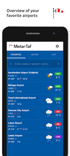
- Flight rules category: VFR, MVFR, IFR, LIFR
- Read out by text-to-speech available, listen to a decoded METAR while doing other things
TAF features:
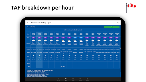
- TAF broken down and displayed per hour in a table
- Show sunrise/sunset, minimum and maximum temperature
Keeping track:
- Add your favorite stations to the list, see their weather at a glance
- Get observations near your location
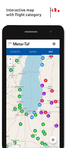
- Find stations in the interactive map with weather codes
- Search airports by ICAO code or name
History:
- Graphs with weather trends today and yesterday: temperature, visibility, wind speed, QNH
- METAR history for the last hours and link to more on the website
Airport information:
- See information about the airports, like runway directions, elevation, location
- If the airport doesn't report a METAR, the nearest station used for calculations
Calculations:
- All units are customizable units: speed (knots, km/h, m/s, mph), altitude (meters/feet), visibility (kilometers/miles), temperature (Celcius/Fahrenheit) and air pressure (Hectopascal, Inch Hg)
- Times are converted to the local time for each airport
- Sunrise and sunset are calculated based on the airports latitude/longitude
General:
- METAR, TAF and airport data are automatically saved for offline use
- Available in 6 languages: English, Dutch, Spanish, Portuguese, German and French
Version Information
- Version
- 2.8.0
- Downloads
- 10K+
- Updated on
- Oct 27, 2025
- Released
- Aug 28, 2021
- Requires
- Android 7.0
Statistics
Google Play Rating History
Rating Distribution
Downloads Over Time
Metar-Taf - Visual decoder has been downloaded times. Over the past 30 days, it averaged downloads per day.
Shaded area shows 30-day prediction based on historical trends
Historical data collection started recently. More data points will be available over time.
Metar-Taf - Visual decoder - Google Play Rankings
Top Rankings
| Rank | Country | Category | List | Change |
|---|---|---|---|---|
| — |
Ranking History in
No ranking data available yet. Rankings are updated daily.
#19 in Top Paid Weather in United States

#6 in Top Paid Weather in France

#9 in Top Paid Weather in United Kingdom


#12 in Top Paid Weather in Thailand

Metar-Taf - Visual decoder users say on Google Play
 Tyler Heer
Cool App, works well, great visualizations. However, have a recommendation. Would like to be able to re-sort the order of the listing. Would like to rearrange based on circular proximity of my home base airport. Otherwise, will have to delete and plan out the desired airports and add in specific order. Edit - Nevermind, developer responded super quick and advised that I just need to swipe left and the option to move up or down is there. Problem solved! Tha KS for super fast reply!!!
 Nathan Novak
It's hands-down the best METAR/TAF decoder on Android. My only complaint is that, sometimes, the runway position on the compass gets flipped-flopped for airports with two runways. Please take a look at SACO in Cordoba, Argentina as an example.
 Brian Petry
does not update Metars for certain airports sometimes for days, I have one near me that every weekend stops working despite up to date weather data available.
 Andy Mckeen
Does what it says it does, but certainly not worth the money. Not super well put together, and some features just send you to their free website anyway. Do not pay for this app.
 Marty Duke
I just installed it on my Samsung S22U. It has location permissions, but it won't locate nearby airports here in Seattle. The wheel just keeps spinning when I click on nearby or on map. Please advise.
ApkTrusted Ratings & Reviews
More from Studio Eveline
See more apps


Similar Apps

Windmate
Paid
Rivercast - River Levels App
Free

Gaggle Paragliding, Ultralight
Free
Windfinder Pro: Wind & Weather
Paid
St. Cloud Live StormTRACKER
Free

BassForecast: Fishing Forecast
Free

Toptracer Range
Free

Rain Bird Resources
Free

TeeTime Golf Pass
Free

The Masters Golf Tournament
Free

Airhead ATPL
Free

GOLFFOREVER
Free

Deep Dive - Bass Fishing App
Free

Emergency: Severe Weather App
Free

Sport Track Merger
Free

Live Weather Forecast : VR
Paid
Scan this QR code to download

Forwarding you to the page at Google Play market in seconds...
Open Google Play market now