Aqua Map Boating v42.2
GEC S.R.L.


About this app
Developer Description
US Charts from NOAA, ACoE Surveys, Marine Forecasts, Anchor Alarm and more...
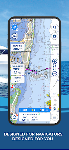
Aqua Map offers weekly updated OFFICIAL NAUTICAL CHARTS (NOAA) for marine navigation. Purchase a chart subscription for the area of your interest, download the map areas for offline use, and connect your onboard instruments for a complete experience.
● BASIC FEATURES
- Switch between manual and auto route planning modes
- Record your GPS tracks
- Store and share your navigation data (markers, routes, and recorded tracks)
- Display tides and currents predictions and simulations
- Increase your safety with Anchor Alarm
- Enable Live Sharing to interact with the Aqua Map community
- Display points of interest from the "ActiveCaptain" and "Waterway Guide" communities
● EXPERT SUBSCRIPTION
Note: this subscription does not include charts; it must be paired with a chart subscription.
- Marine forecasts (wind, waves, currents, gusts, salinity, sea surface temperature + weather information for any point on the map)
- Overlay satellite images on the charts
- Advanced AnchorLink with anchorage mirroring and email/telegram notifications for greater peace of mind while anchored, even if you are away from the boat
- Connect your NMEA instruments via WiFi (autopilot, depth sounder, wind sensor, compass, GPS) and use their data on the app
- AIS with automatic collision detection
- Route Explorer for real-time information on all elements along your route
● MASTER SUBSCRIPTION FOR THE BEST NAVIGATION EXPERIENCE
Note: this subscription does not include charts; it must be paired with a chart subscription.
- All features of the EXPERT subscription are included in the MASTER subscription.
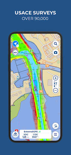
- U.S. LOCAL DATA:
> U.S. Army Corps of Engineers surveys for safe navigation in shallow waters
> U.S. Coast Guard lights list and local notice to mariners
● PURCHASE OPTIONS
To access the charts, you need to purchase a chart subscription for the area of interest. Optionally, you can add the Expert subscription or the Master subscription to unlock extra navigation features and additional data. Subscription payments will be made through your Google account. The annual subscription will automatically renew unless canceled at least 24 hours before expiration. You can manage your subscription and disable automatic renewal in the account settings section after purchase.
End User License Agreement: https://www.aquamap.app/eula
Terms of use: https://www.aquamap.app/terms-and-conditions
Privacy policy: https://www.aquamap.app/privacy-policy
What's New
In-app purchases
$2.99 - $139.99 per item
Version Information
- Version
- 42.2
- Downloads
- 100K+
- Updated on
- Nov 28, 2025
- Released
- May 14, 2018
- Requires
- Android 8.0
Statistics
Google Play Rating History
Rating Distribution
Downloads Over Time
Aqua Map Boating has been downloaded times. Over the past 30 days, it averaged downloads per day.
Shaded area shows 30-day prediction based on historical trends
Historical data collection started recently. More data points will be available over time.
Aqua Map Boating - Google Play Rankings
Top Rankings
| Rank | Country | Category | List | Change |
|---|---|---|---|---|
| — |
Ranking History in
No ranking data available yet. Rankings are updated daily.
#44 in Top Grossing Maps And Navigation in United States

#44 in Top Grossing Maps And Navigation in Canada

#89 in Top Grossing Maps And Navigation in Brazil

#100 in Top Grossing Maps And Navigation in Australia
 GPS Coordinates Tracker
Aqua Map Boating
GPS Coordinates Tracker
Aqua Map Boating
Aqua Map Boating users say on Google Play
 Steve Murphy
As a follow up on previous post: The app seems to have stabilized and now loads up and holds onto downloaded charts. It has not crashed again. It puts much information that previously took a lot of time to gather for cruising long distances. Having it on Android device helps to quickly look up info. needed on a cruise. If I can get it to work on Windows OS with emulator, will be a great 2nd nav. program.
 John Morfit
The app is mostly solid, and my go to planning tool. The anchor function has a few bugs and design shortcomings that prevent me from using it.
 Ed Herlihy
Update: losing a star b/c it crashes. Recovery is to delete & reinstal Have been running this app on my phone and tablet for over a year. It is a MUST HAVE for navigating the AICW! The Army Corps of Engineers does frequent surveys that are quickly posted to the Aqua Map charts, and are later posted to the official NOAA charts. The upgrade to Aqua Map Master allows real time display of NMEA 2000 instruments (depth sounder, AIS, etc.). Unfortunately the upgrade is only available on a subscription.
 G. Macfarlane
Displays the downloaded raster tiles in a sporadic pattern rendering it unusable. Tried on both phone and tablet. Some tiles are there others (which show as downloaded) fail to display. Going back to Navionics which always works on the same devices.
 glen coombs
The app is nice but is not compatible with needed accessibilty settings on my S22 Ultra. It requires me to use the lowest screen zoom setting which makes the text on all other apps so small that I can't read it. So it's either A) change the screen zoom setting every time I open the app and change it back when I close the app or B) just find another app. I chose option B.
ApkTrusted Ratings & Reviews
More from GEC S.R.L.
See more apps
Similar Apps

VesselFinder
Free

DeRadar
Paid

Holland America Line Navigator
Free

Orca: Boat GPS, Charts, Routes
Free

Gaggle Paragliding, Ultralight
Free
ShipAtlas - Ship Tracker
Free

Wanderz - Travel Guides
Free
Windfinder Pro: Wind & Weather
Paid

MarineTraffic - Ship Tracking
Free

GPS Essentials
Free

Nautide: Tides, Wind, Waves +
Free

Wavve Boating: Marine Boat GPS
Free
Navionics® Boating
Free

Windmate
Paid

Planes Live - Flight Tracker
Free

WeFish | Your Fishing Forecast
Free
Scan this QR code to download

Forwarding you to the page at Google Play market in seconds...
Open Google Play market now