
Avia Maps Aeronautical Charts vVARY
Remy Webservices UG


About this app
Developer Description
Straightforward Aeronautical Charts for flight planning and navigation.
Global, high resolution weather forecasts from the German DWD and US American NOAA provide accurate map layers for cloud cover, ceiling, precipitation, wind on the ground as well as aloft. The data is downloaded onto the device, so you can check the forecast even during flight without cell reception. To retrieve the latest METAR and TAF at your destination airport it is integrated with Avia Weather.
A digital elevation model supports you with planning your route in the mountains. During flight the terrain overlay will dynamically color hills and mountains on the map depending on your current altitude to increase your situational awareness.
To enhance safety, Avia Maps can display traffic information from your favorite ADS-B receiver or from the SafeSky app directly on the map. It supports receiving traffic data using the GDL90 format, which is supported by most portable ADS-B receivers like SkyEcho or Stratux. If you do not have a receiver, SafeSky can provide traffic data using an internet connection only.
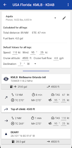
For the most accurate performance calculations you can create multiple aircraft profiles from handbook values for climb performance, fuel consumption etc. Route calculations will use these profiles and even consider engine type and fuel burn for climb performance, employing common formulae used in aerospace engineering. From as little as four carefully chosen data points the app can accurately recreate the climb performance diagram in your POH.
For clarity and commonality to paper charts the map is themed in the style of ICAO Annex 4 (Aeronautical Charts). If you use the app on multiple devices you can synchronize your routes, aircraft profiles and user waypoints between them.
This is a trial app with full features. After an evaluation period of 30 days you will have to buy a perpetual license from within the app or subscribe to the professional tier.
What's New
In-app purchases
$0.99 - $49.99 per item
Version Information
- Version
- -
- Downloads
- 100K+
- Updated on
- Dec 7, 2025
- Released
- Aug 26, 2016
- Requires
- Android Varies with device
Statistics
Google Play Rating History
Rating Distribution
Downloads Over Time
Avia Maps Aeronautical Charts has been downloaded times. Over the past 30 days, it averaged downloads per day.
Shaded area shows 30-day prediction based on historical trends
Historical data collection started recently. More data points will be available over time.
Avia Maps Aeronautical Charts users say on Google Play
 Chris de Witt
Awesome value. Hope to see the South African flight information region boudaries (FIR) and the related frequencies soon.
 Alex Bolinger
Overall not too bad of an app. Displays good information. GPS position seems accurate. I would like to be able to zoom in more. I would also like the awos frequencies to be included in the airport information.
 Tony Aldama
Want to give five stars but it's lacking some very important features. As far as I'm aware, there is no nighttime mode, so if you fly at night you will have a ton of white light coming out of this app, which we all know destroys night vision, even on low brightness, so this app is almost useless at night. Second, it does not display obstacles on your route. There are several cell towers in my area that go all the way up to 2,000 feet, yet they are not displayed. Very dangerous!
 Stephan B.
Wants to have all sorts of privacy and account permissions just to open the app. Nope.
 Johnny Payne
Do not waste your time. Two hours over a high speed business net and still did not load correctly. Contained corrupt files, failed to download other files and even when I selected the sectional for my area, even after an hour still could not use because the file was corrupt. Because of this I did a virus scan to makes sure my flight tablet was safe. DO NOT USE THIS!!
ApkTrusted Ratings & Reviews
More from Remy Webservices UG
See more apps

Similar Apps

Gaggle Paragliding, Ultralight
Free

Bike Route Planner
Paid

Windmate
Paid

Plane Finder - Flight Tracker
Free

VesselFinder
Free

Orca: Boat GPS, Charts, Routes
Free

Matterhorn
Free

FarOut
Free

ShipAtlas - Ship Tracker
Free

Holland America Line Navigator
Free

WeFish | Your Fishing Forecast
Free

swisstopo
Free
Windfinder Pro: Wind & Weather
Paid

Nautide: Tides, Wind, Waves +
Free

GPS Navigation Route Planner
Paid

AeroGuest
Free
Scan this QR code to download

Forwarding you to the page at Google Play market in seconds...
Open Google Play market now