PredictWind Offshore Weather v7.5.0.0
PredictWind Limited


About this app
The PredictWind Offshore Weather app solves the problem of accessing reliable marine weather forecasts for offshore activities, benefiting sailors, fishermen, and other marine enthusiasts who require accurate and up-to-date weather information. Compared to other weather apps, PredictWind stands out with its ability to provide GRIB files and forecasts, making it a valuable tool for those who spend extended periods at sea. With a good user rating of 4.0 and over 50,000 downloads, it has established a positive reputation among its target audience. However, its limited functionality and lack of additional features beyond marine weather forecasting may make it less appealing to casual users.
Pros
- The app's ability to provide GRIB files and forecasts is a significant advantage for offshore enthusiasts who require detailed and accurate weather information to plan their activities safely.
- With no ads or in-app purchases, the app offers an uninterrupted user experience, allowing users to focus on the weather data without distractions.
- The developer's reputation and website suggest a commitment to providing high-quality weather forecasting services, which enhances the app's credibility and trustworthiness.
- The app's offline capability is a significant advantage for users who often find themselves without internet access while at sea, ensuring they can still access critical weather information.
- The app's simplicity and focus on marine weather forecasting make it easy to use, even for those with limited technical expertise.
Cons
- The app's limited functionality may not appeal to users who are looking for a more comprehensive weather app that includes additional features such as radar imagery or weather alerts.
- The lack of permissions requested by the app may raise questions about how it intends to improve its services or provide personalized experiences without collecting any user data.
- Some users may find the app's user interface and design to be less visually appealing or less intuitive compared to other weather apps available on the market.
- The app's update frequency and responsiveness to user feedback could be improved to address any issues or concerns that users may have and to ensure the app remains relevant and effective.
Best for: The ideal user for the PredictWind Offshore Weather app is an experienced sailor, fisherman, or marine enthusiast who regularly engages in offshore activities and requires accurate, detailed, and reliable marine weather forecasts to plan their voyages safely and efficiently, likely with a moderate to high level of technical skill and familiarity with weather forecasting terminology and concepts.
Developer Description
The Marine Weather App for getting GRIB files & viewing forecasts when offshore
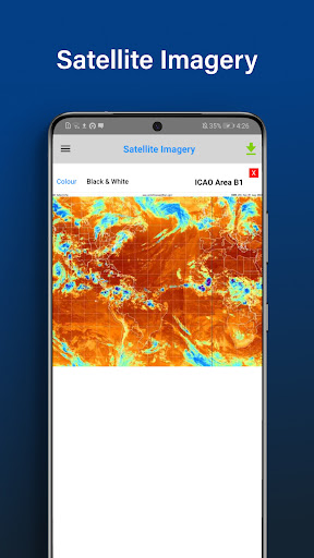
Quickly download and view GRIB files, weather routes, GMDSS maps and text forecasts, AIS data and satellite imagery.
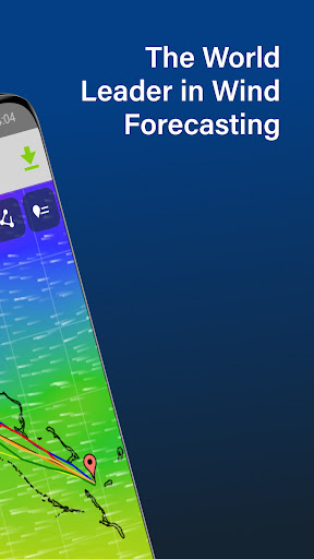
Access all the world’s top ranking forecast models for reliable and accurate weather data, including ECMWF, SPIRE, UKMO, GFS and more. Our very own PWG & PWE models offer incredible accuracy and a record-breaking 1km resolution.
In addition to forecasts, the Offshore App also provides a suite of powerful marine tools to save you time and keep you safe at sea.
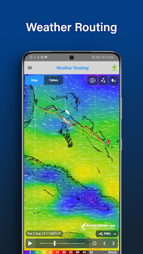
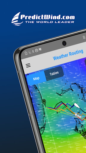
Weather Routing and Departure Planning is calculated in the PredictWind cloud at the highest resolution. The finished route is then sent back to your boat in an incredibly small file size, which is ideal for low bandwidth satellite and SSB connections.
The Offshore App works with Wi-Fi, mobile networks, and most satellite connections using an Iridium GO! exec, Iridium GO!, Globalstar or Optimizer device.
ADDITIONAL FEATURES
GRIB file viewer: High resolution forecasts maps with animated streamlines, wind barbs or arrows.
Tables: The ultimate dashboard for detailed analysis.
Graphs: Compare multiple parameters at the same time.
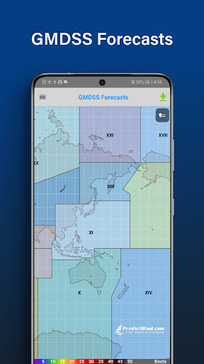
GMDSS Forecasts: View either in the traditional text format or on a map.
Destination Spot Forecast: Know exactly what the weather is doing at your destination.
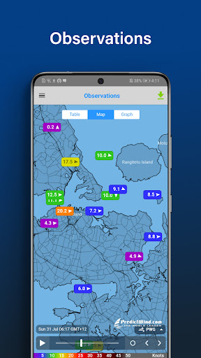
Live Observations: Know what’s happening right now out on the water.
Ocean Data: See what’s happening under the waves with ocean and tidal currents, and sea temperature.
GPS Tracking: Get a free customised GPS tracking page for your blog or website.
AIS Data: View over 280,000 vessels worldwide on the AIS network.
Privacy
Given that the PredictWind Offshore Weather app requests no permissions, it does not collect any sensitive user data, which is a positive aspect in terms of privacy. However, users should still be cautious when using any weather app and ensure they understand how their data might be used if the app's permissions or policies change in the future. It is also essential to keep the app updated to ensure any security patches are applied.
Tips
To get the most out of the PredictWind Offshore Weather app, users should first familiarize themselves with the different types of forecasts and GRIB files available and how to interpret them. Additionally, ensuring the app is updated regularly will help users access the latest forecast models and improvements. For optimal performance, it's also a good idea to clear the app's cache periodically, especially if the user notices any slowdowns or data refreshing issues.
What's New
. New map tool tip UI
. New source of Satellite Imagery to replace our old source that is no longer available.
. bugfixes
Version Information
- Version
- 7.5.0.0
- Downloads
- 50K+
- Updated on
- Sep 2, 2024
- Released
- Mar 6, 2017
- Requires
- Android 8.0
Statistics
Google Play Rating History
Rating Distribution
Downloads Over Time
PredictWind Offshore Weather has been downloaded times. Over the past 30 days, it averaged downloads per day.
Shaded area shows 30-day prediction based on historical trends
Historical data collection started recently. More data points will be available over time.
PredictWind Offshore Weather users say on Google Play
 J Cover
This is one app that works offshore for cruising boats..or powerboats. Gives good weather projections..via cell or sms device like InReach. We do not go offshore without it. It takes a bit if understanding of weather charts..but the geaogicsxrealky assist in this process. By the way..weather takes understanding and learning about ..this app is the best tool to help visual and route and passage plan. They have excellent models..
 Patrick OSullivan
I like the app in that the files are small and can be downloaded with intermittent cell signal as we are traveling along the Southeast US coast. The usage is not always intuitive so I practice everyday so I do not forget how to look at different areas and adjust parameters. However, this is a valuable tool and I highly recommend it.
 Richard Hudson
Comprehensive, but with a poor user interface. If one wants to know wind speed, direction, gusts and pressure at one spot, the screen layout is 5% menu, 5% useful information, and 90% distracting animation of wind moving across screen. This makes the weather information that I want from the app difficult to read.
 ELA SARAMETESCU
App is packed with a lot of usefull things. Too bad they don t work for me. Most of the prediction files do not download, saying that my user and password are incorrect. The ones that get downloaded are not displayed on the map. The map zooms out to world view everytime i go to some menu. Used help. Doesn t seem i do sonething wrong or got the settings wrong. But problems still persist
 Robert Carpenter Shook
The android app is really pathetic. The iPad app is fine, the computer app is fine, but across multiple devices for years the android app is buggy, freezes, quits, can't load features, etc. It's usable but barely. - pro subscriber
ApkTrusted Ratings & Reviews
More from PredictWind Limited
See more apps


Similar Apps
Windfinder Pro: Wind & Weather
Paid

NOAA Weather Unofficial (Pro)
Paid

VesselFinder
Free
St. Cloud Live StormTRACKER
Free
Windfinder: Wind & Weather map
Free

WeFish | Your Fishing Forecast
Free

Nautide: Tides, Wind, Waves +
Free

Gaggle Paragliding, Ultralight
Free

Deep Dive - Bass Fishing App
Free

Holland America Line Navigator
Free
Rivercast - River Levels App
Free
Weather & Radar USA - Pro
Paid

Orca: Boat GPS, Charts, Routes
Free

WeatherX Forecast
Free
BassForecast: Fishing Forecast
Free

Weather data & microclimate :
Free
Scan this QR code to download

Forwarding you to the page at Google Play market in seconds...
Open Google Play market now