
Hunting Gps Maps, Topo +Trails v177.0
Gps Nautical Charts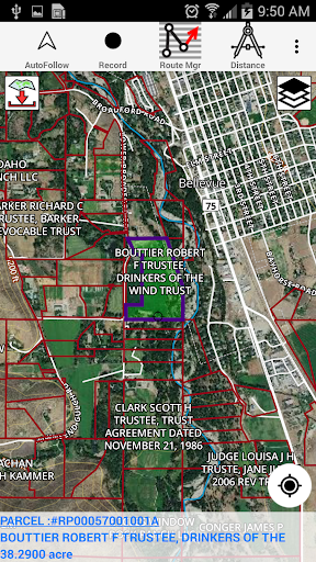


About this app
Developer Description
Hunt GPS w/ Land Ownership maps, Property Lines, hunt zones & restricted areas
lands, land ownership details. Map layers for 50+ states include hunting
zones, restricted areas, possible access areas, state refgues and more.
Vector topo maps with most accurate USGS elevation contours, hiking & biking
trails. Coverage includes all US states.
► Vector Topo Maps
√ Beautiful & detailed Hardware/GPU accelerated vector maps (text stays upright on rotation)
√ Vector USGS contours (Change height to ft or meter).
√ Covers popular hiking & biking trails and paths
► Parcel Maps
√ Includes following ownerhsip attributes (where available)
* Owner name and Owner address
* Site Address
* Parcel ID Total Value
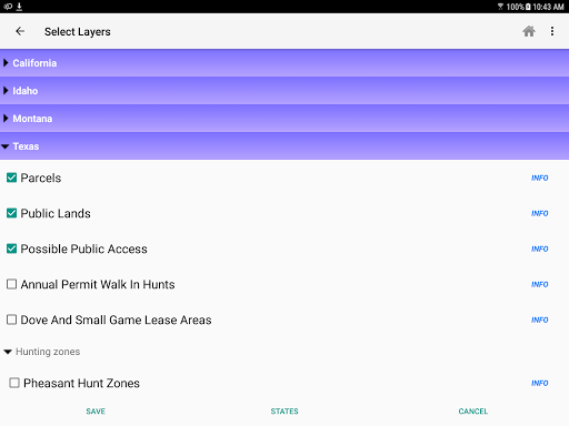
► Hunt Planning maps
√ Possible Public Access
√ Public lands and Parcels
√ Hunting Zones
√ Game Distribution
√ Restricted Ares
√ Portions
► Offline vector maps
√ Easy to download offline topos
► PLSS maps
√ PLSS Townships and Sections (US Wide coverage)
► Custom base maps
√ Switch base maps between vector topos, hybrid satellite imagery and more
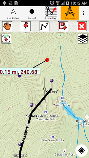
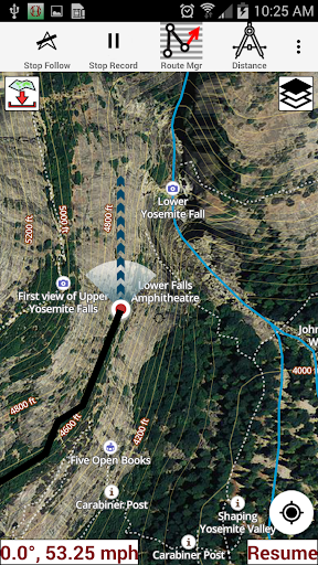
►GPS FEATURES
√ Record Tracks
√ Enter or import Waypoints.
√ Auto Follow
* Real Time Track Overlay
* Predicted Path Vector
* Course Up(Text stays upright)
* Speed & Heading
√ Route Assistance With Voice Prompts
* Prompts when approaching a boating route marker
* Continous distance & ETA updates
* Alerts when off route
* Alerts when moving in wrong direction
►ROUTE MANAGEMENT / TRIP PLANNING
√ Create New Route/Edit Existing Routes
√ Move Points
√ Add points to an existing route leg
√ Delete / Rename points
√ Import GPX,KML & KMZ files
√ Plot/Edit Routes
√ Enter Waypoints
√ Share/Export Routes,Tracks&Markers
√ Reverse Routes
► SHARING
* Share tracks/routes/markers on Facebook & Twitter
* Export tracks/routes/markers as compressed GPX files.
► Topo & Trail Maps for National Parks
Detailed topographic trail maps are included for national and state park including::
√ Great Smoky Mountains
√ Grand Canyon
√ Zion
√ Rocky Mountain
√ Yosemite
√ Yellowstone
√ Acadia
√ Olympic
√ Denali
√ Glacier
► Weather Forecasts
Animate weather forecast overlays for the following.
√ Wind Speed and Directions (GFS & ECMWF)
√ Wave Heights (Swell + Wind combined) and Direction(GFS & ECMWF)
√ Pressure (MSL) (GFS & ECMWF)
√ Precipitation
√ Air Temperature (GFS & ECMWF)
√ Gust
√ Lake Temperatures
Comfortable Weather Settings
√ Automatically Highlight Harsh Weather Forecasts
√ Weather settings are customizable based on your preferences.
► Suggested Uses for i-Hunting Topo Maps
√ Hunt Planning & Recon
√ Off trail and On trail hiking
√ Backpacking : Use Topos of National Forests and Wilderness areas with GPS
√ Snow Sports (Snow Shoeing, Skiing, Snowboarding, Snow Mobiling)
√ SAR (Search and Rescue)
The i-Hunting application can turn your phone into full fledged outdoors GPS unit (like Garmin ® or Magellan ® outddor GPS). The app compliments the gear you got from Dick's ® , REI ® , Cabelas ® etc.
What's New
- Weather map overlays improvements
- Way Point improvements.
-MAJOR UPDATE
-- Weather Map overlays (Wind, Wave, Pressure, Precipitation, Temperature, Gust)
-- Adjust comfortable values for weather overlays
-- Lake Temperature Maps
-- New search algorithm that shows results as you type in
In-app purchases
$19.99 - $29.99 per item
Version Information
- Version
- 177.0
- Downloads
- 100K+
- Updated on
- Nov 19, 2025
- Released
- May 23, 2012
- Requires
- Android 5.0
Statistics
Google Play Rating History
Rating Distribution
Downloads Over Time
Hunting Gps Maps, Topo +Trails has been downloaded times. Over the past 30 days, it averaged downloads per day.
Shaded area shows 30-day prediction based on historical trends
Historical data collection started recently. More data points will be available over time.
Hunting Gps Maps, Topo +Trails users say on Google Play
 Tim Brown
I had trouble that others seem to have had. I contacted developer and they were able to fix this problem. I like this app and am happy now. It is worth the price. If you have problems they can help you.
 Mark Wallace
I like it and use it often. However, the app just started giving me a message that I would need to upgrade to use network data! And, when I push the button to show my location, it stopped working and gives a message that I need to upgrade- for another $20!! I guess I dont mind uograding, but no where in the desription did it say I would need to pay addtional fees!
 ritacate
I used this occasionally to make sure I was hiking public land. One day I turned it on and there's simply nothing there. I understood the free version to be ONE area rather than the whole country. There is nothing stating it's a limited time app. Since I travel and was happy with this, I likely would have purchased a fuller version. Since I feel lied to, I will look elsewhere. Neither can I recommend this to my nephew just asked for my experience. I cannot comment on how current the info was.
 RODNEY Vargeson
Update; was told it was a 1 time fee. Got charged again. Landowners are way out of date. People on my street moved 5 years ago, still showing their names. Installed a different app, landowners name is correct. So far so good! It appears that it's very accurate for boundaries. I've only used it for about a week. I'll update if anything changes! Knocked down to 4 stars. Map is glitchy for some reason. Still like it.
 Jordan V
Can't use the locate button on gps without upgrading, the map starts presumably at the office of the developer. You'd be better off hunting from Google maps.
ApkTrusted Ratings & Reviews
More from Gps Nautical Charts
See more apps
Scan this QR code to download

Forwarding you to the page at Google Play market in seconds...
Open Google Play market now