i-Boating:Marine Navigation v276.0
Gps Nautical Charts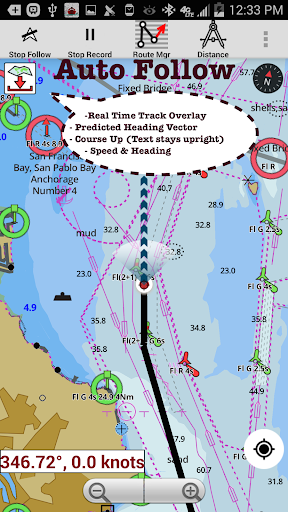


About this app
Developer Description
Chartplotter:Lake depth Maps 4 Fishing,Nautical/Marine Charts w/ Marine Weather
Nautical Charts w/course up orientation. Incl Tide Charts & Currents prediction for nautical navigation. Create Boat routes / Waypoints, or import existing GPX/KML routes on device. Has Marine AIS(NMEA) support.
►FEATURES
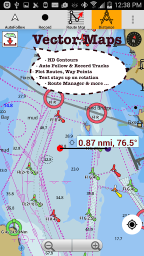
√ GPU accelerated offline vector NOAA charts/ENC charts (text stays upright)
√ Lake depth map shading/safety lake depth contours:custom boat safety depth
√ Maritime Aids to Boat Navigation : Beacons,Buoys,Boat Launch areas,Boat Ramps,Marina, Fishing Attractors
√ Record marine tracks, Autofollow with real-time track overlay
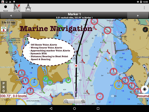
√ Voice Prompts for marine navigation
√ HD 1ft/3ft depth lake contour maps for anglers for selected lake maps: for fishing/trolling(freshwater/saltwater).
√ GPX/KML for boat route.
√ Seamless marine chart quilting: Coastal, Approaches,Harbour & Inland ENC(Electronic Marine Charts)
√ Superset of Navionics, C-Map,Lowrance,Argo,Wavve,Savvy Navvy,Predict Wind & Windy.
√ Waypoints
√ Tide & Currents.
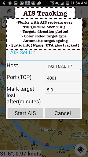
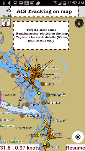
√ Marine AIS
√ Anchor Alarm
√ Magnify Text & Icons
√ Wind Prediction Overlay
√ Bearing True/Magnetic
► Fishing Hot Spots AI
►Lake Temperature Maps(Thermoclines 1°F (0.5° C)
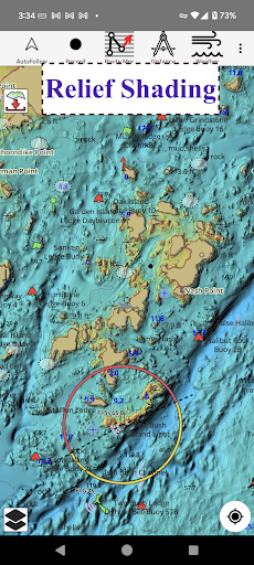
►Relief Shading
► Public Private Ownership Overlay(Parcel Maps)
► MAPS
Marine chartplotters details!
Unlimited updates for 1 year.
USA:Maps incl NOAA marine charts,ENC,USACE inland river maps & freshwater lake bathymetry maps for 75K+ lakes. Charts incl HD/1ft bathymetry. Incl NOAA marine charts(rasters) w/ NOAA ENC coverage.
Canada:CHS data Incl Great lakes,Alberta & Ontario lakes,Lake Simcoe&Trent Severn Canal,Quebec reservoirs.
UK/Ireland:UKHO marine charts
Germany:BSH charts,Waterways & rivers.
France
Europe Inland Rivers:Donau/Danube/Dunaja,Rhine,Rhein
Australia
Netherland/Holland
Croatia
Finland
Norway
Sweden
Brazil
Spain
Malta,Cypress,Mediterranean Sea
Caribbean
New Zealand
Denmark,Greenland,Faroe
Seychelles,Mauritius,Tanzania
Falklands
Malaysia,South China Sea
Persian/Arabian Gulf,Red Sea
South Africa
Argentina
Iceland
Fiji
Estonia,Latvia,Poland,Lithuania
Turkey,Greece,Italy
►Instrumentation
√Marine AIS & (NMEA AIS and GPS - TCP/UDP)
√Wind direction & Speed,Marine Sonar depth,Water temperature
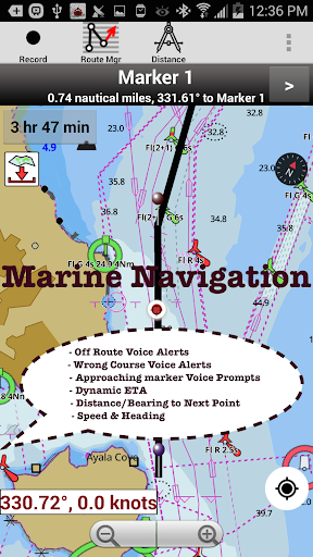
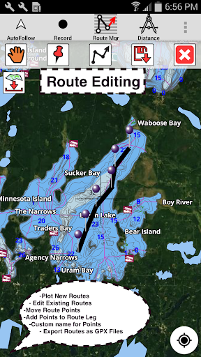
►ROUTE MANAGEMENT/TRIP PLANNING
√Create/Edit/Reverse Boat Routes
√Waypoints mgt
√Import GPX,KML & KMZ files
√Share/Export Routes,Boating log,Tracks&Markers
►BOAT NAVIGATION
√Auto Follow
*Real Time Overlay & Predicted Path Vector
*Course Up
*Speed & Heading
√ Route Assistance With Voice Prompts
*approaching boating route marker prompt
*RT nautical distance & ETA
*sailing/boating off route/wrong direction
√ Record Tracks
►TIDE & CURRENTS
*High/Low Tides
*Tidal Current Prediction
►Marine Weather
*GFS+ ECMWF
►SHARING
*Export GPX.
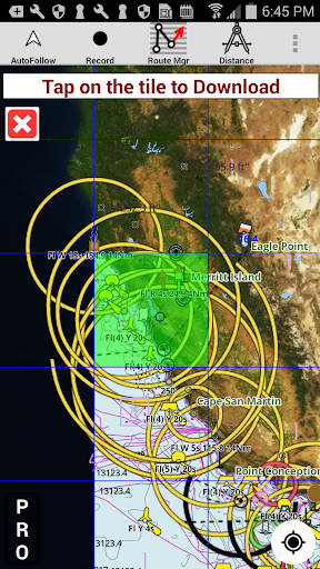
►Satellite Imagery
►USA Marine Charts
*Texas Lakes Texoma,Eufaula,Toledo Bend
*California Lakes Tahoe,Shasta
Pennsylvania Lakes Raystown
Florida Lakes Okeechobee,Kissimmee
*Minnesota Lakes Minnetonka,Waconia,Leech,Mille Lacs
*Massachussets lakes Quabbin
*Missouri Lakes Truman
*Ohio Lake maps Lake hoover
*Wisconsin Lakes Winnebago,Pepin
* Utah Lake Powell,Bear
*Maine Lake Sebago
*Alaska Lakes:Winnipesaukee
*Tennessee Lake Barkley,Norris,Watts Bar
*South Carolina Lake Keowee,Hartwell,Murray
*Lake Michigan,Huron,Ontario,Superior,Erie
►Canada Lakes Maps
*Lac Saint Jean
*Ontario Lake depth maps
*Rideau Canal-Ottawa River
*British Columbia Marine Charts
*Pacific Coast-Vancouver-Haida Gwaii
*Nova Scotia -Bay of Fundy
*Quebec-Anticosti Island
*Newfoundland
*St Lawrence river
*Manitoba & Saskatchewan
*Georgian Bay
*Puget Sound
►UK Nautical Charts
*Scotland
*Thames Estuary
*Ireland
►Australia Marine & Lake Maps
*NSW
*Queensland
What's New
Highlight Fishing Depth Range
RELIEF SHADING
Lake Temperature
Marine Weather Forecast
Fishing AI
NMEA ALARMS:Depth+Wind
Marine Weather:Wind,Wave
Automatic Boat Routing
UK Tide & Currents
Magnetic Bearing
Wind Prediction Overlay
Magnify Text+Icons
Anchor alarm
Auto Pilot
Custom depth shading
Satellite imagery
AIS &GPS NMEA TCP/UDP
Russian rivers(Volga)
Wind speed,direction,sonar depth,water temp
Norway,Finland,Denmark
German(Donau,Elbe,Mosel,Rhein,Saar,Weser)
Elbe,Ruhr
In-app purchases
$9.99 - $64.99 per item
Version Information
- Version
- 276.0
- Downloads
- 1M+
- Updated on
- Dec 15, 2025
- Released
- Aug 29, 2015
- Requires
- Android 5.0
Statistics
Google Play Rating History
Rating Distribution
Downloads Over Time
i-Boating:Marine Navigation has been downloaded times. Over the past 30 days, it averaged downloads per day.
Shaded area shows 30-day prediction based on historical trends
Historical data collection started recently. More data points will be available over time.
i-Boating:Marine Navigation - Google Play Rankings
Top Rankings
| Rank | Country | Category | List | Change |
|---|---|---|---|---|
| — |
Ranking History in
No ranking data available yet. Rankings are updated daily.
#20 in Top Grossing Travel And Local in United States


#8 in Top Grossing Travel And Local in Canada

#31 in Top Grossing Travel And Local in Turkey


#42 in Top Grossing Travel And Local in Australia

i-Boating:Marine Navigation users say on Google Play
 V Racan
love it .Excellent for a free app. Other apps show no info on my local river. I also use it for hunting and hiking on land for its follow-me and route recording. Never get lost and/or double-track again!
 jack h.
Good so far. On two cellphones. Certainly capable of giving Navionics a run for its money and less expensive. Querying provider regarding frequency of chart updates. As of 11/1/2025, no answer from provider regarding frequency of updating of charts, despite two requests. This is critical information.
 kevin cox
I have had fun playing with this app. I have used it on bodies of water I regularly fish, to try it out. The depths and contour lines are not always accurate, and the fishing ai is geared toward warm water species, not the salmon and lake trout I fish for in deep water. At least one of the lakes is mis-named. However, I have had fun plotting courses and routes for trolling. Also, the app is fairly easy to use. I have wasted 20 bucks on a lot of worse things.
 te kent
used for over 2 years. I've purchased full subscription and also maps. it just seems to drop maps if I don't use them for 6 months. Really have to study this thing to figure out routes, and impossible to modify.
 Stephen Wells
Buyer beware! I purchased maps, but when I changed phones there was no way to restore my purchases. I have emailed customer support three times over the past two months with no response. Fly by night app developers suck!
ApkTrusted Ratings & Reviews
More from Gps Nautical Charts
See more apps

Similar Apps
ShipAtlas - Ship Tracker
Free

Orca: Boat GPS, Charts, Routes
Free

VesselFinder
Free

Holland America Line Navigator
Free
Navionics® Boating
Free

Wavve Boating: Marine Boat GPS
Free

Nautide: Tides, Wind, Waves +
Free

WeFish | Your Fishing Forecast
Free

MarineRadar: Vessel Tracker
Free

Fishbrain - Fishing App
Free

GPS Essentials
Free

Avenza Maps: Offline Mapping
Free

Guru Maps Pro & GPS Tracker
Paid
BassForecast: Fishing Forecast
Free

HiiKER: The Offline Hiking app
Free

AlpineQuest Explorer Lite
Free
Scan this QR code to download

Forwarding you to the page at Google Play market in seconds...
Open Google Play market now