
Guru Maps Pro & GPS Tracker v5.9.2
Evgen Bodunov
About this app
Developer Description
Get a map before your next journey and navigate with confidence even offline.
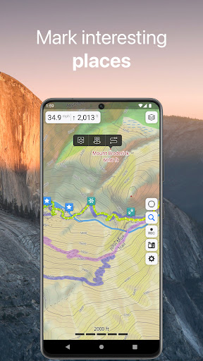
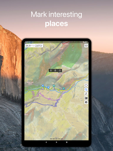
Offline Maps
• High-resolution & based on OpenStreetMap (OSM) data.
• Updated monthly with the most-recent fixes and additions.
• Adjustable font size of the labels for better readability.
• Multiple custom map layers can be shown above the base one (GeoJSON support).
• Hillshade, contour lines and slope overlays for relief visualisation.
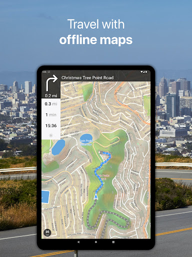
Offline Navigation
• Turn-by-turn voice-guided driving directions with alternate ways.
• Multi-stop navigation with the route optimization feature (circuit route planner).
• Voice instructions while navigating available in 9 languages.
• Routes for Driving/Cycling/Walking/Shortest Distance.
• Automatic rerouting gets you back along your way, even offline.
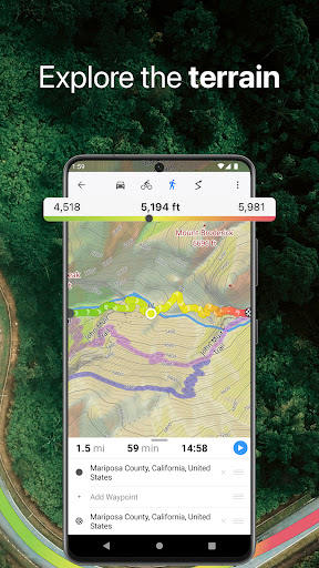
Drive Offroad
• There is an option for choosing the type of bike to build the perfect route, given the pavement (road surface): road, city, touring, mountain (MTB), trekking or gravel bikes.
• Plan an off-road overland trip in your 4x4 vehicle (quad, ATV, UTV, SUV, jeep) or moto, relying on topographic data in order to avoid trickier terrain. Find trails, campsites, adequate gas stations and other destinations along the route, even during an offline mode.
• The trip monitor shows the orientation (compass), accurate speed in mph, km/h or knots units (speedometer), distance (odometer), bearing line and azimuth during the trip. The app collects data from multiple satellites orbiting the Earth.
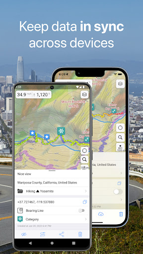
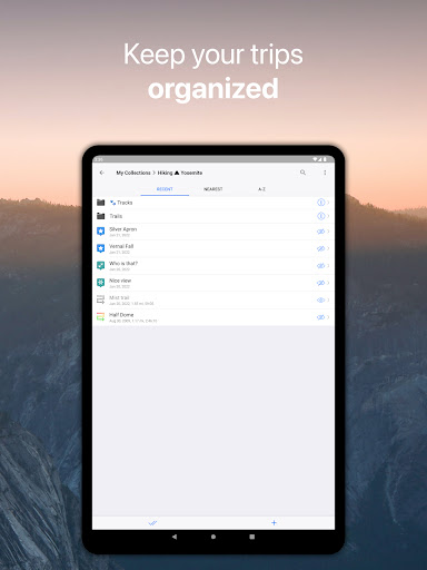
Synchronization
• Seamless sync your data across multiple iOS/Android devices as long as they are authorized with the same account.
• All the data such as saved places, recorded GPS tracks and created routes will be synced on all your devices on both OS platforms.
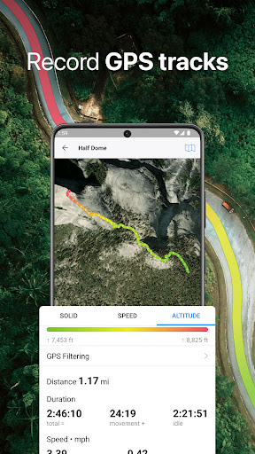
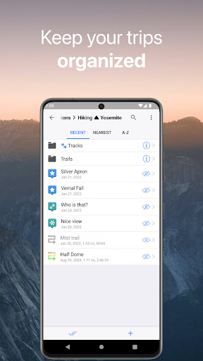
GPS Tracker
• Track the exact location of your phone & tablet real time.
• Record your footpath even when the app is in the background.
• Monitor detailed statistics of your ride: current speed, distance, time traveled, altitude.
• Choose from seven solid track colors, or altitude and speed gradients.
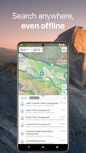
Offline Search
• Incredibly fast – results appear instantly as you type.
• Searches simultaneously in multiple languages, making searching easier than ever.
• Search in a variety of ways – by address, object name, category, or even by GPS coordinates. Supported coordinates formats: MGRS, UTM, Plus codes, DMS, latitude & longitude (decimal degrees (DD), degrees and decimal minutes, sexagesimal degree).
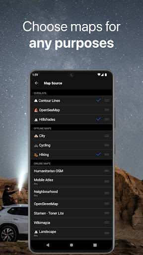
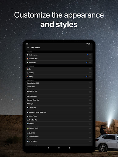
Online Maps
• Pre-installed online map sources: OpenCycleMap, HikeBikeMap, OpenBusMap, Wikimapia, CyclOSM, Mobile Atlas, HERE Hybrid (satellite), USGS - Topo, USGS - Satellite.
• Even more sources available for adding: OpenSeaMap, OpenTopoMap, ArcGIS, Google Maps, Bing, USGS etc from here: https://ms.gurumaps.app.
Supported File Formats
Support for a variety of file formats, including:
.GPX, .KML, .KMZ - for GPS-tracks, markers, routes or whole travel collections,
.MS, .XML - for custom map sources,
.SQLiteDB, .MBTiles - for offline raster maps,
.GeoJSON - for overlays.
What's New
• Bug fixes and performance improvements.
Version Information
- Version
- 5.9.2
- Downloads
- 50K+
- Updated on
- Nov 24, 2025
- Released
- Apr 13, 2017
- Requires
- Android 5.0
Statistics
Google Play Rating History
Rating Distribution
Downloads Over Time
Guru Maps Pro & GPS Tracker has been downloaded times. Over the past 30 days, it averaged downloads per day.
Shaded area shows 30-day prediction based on historical trends
Historical data collection started recently. More data points will be available over time.
Guru Maps Pro & GPS Tracker users say on Google Play
 Yuriy Sapronov
After testing several apps that claim they work offline and discovering that they don't I played with Guru Maps and it was my happy moment. Offline navigation works flawlessly. If I deviate from the planned route, it recalculates it instantly. It is faster than my old TomTom GPS and has a better user interface (at least in my opinion). It took me a while to learn how to use it since in some scenarios it's not so obvious how to achieve your goal.
 Laurent D
Best offline map. I would love to see tracks elevation/time and elevation/distance graph, also and option to "join" 2 tracks. It would be great also be able to download track directly from gps device via Bluetooth.
 Ernest Wyrick Jr
This is my second time writing about this app. Just as before, this app is a great app. The support team are great and get right on the problem if there is one and fix it quickly. I gave the app 5 stars last time but I have only given the app 3 stars this time. The app is great I use it constantly and have other responders using it as well. But now with such a high price for the app. I can no longer recommend the app to the new first responders in the area. They price themselves out business.
 Richard
An otherwise really good, useful app is let down by causing bad battery drain and questionable support - I reported this battery drain issue, but no response.
 Rieghardt Du Preez
Been using it for a year now and i was really happy with the app. But have put a lot of data on the app and yesterday when I opened the map all my Data I have saved on the map the past year was all gone.
ApkTrusted Ratings & Reviews
More from Evgen Bodunov
See more apps
Similar Apps

GPS Essentials
Free

AlpineQuest Explorer Lite
Free

Magic Earth Navigation & Maps
Free

OsmAnd — Maps & GPS Offline
Free

swisstopo
Free

HiiKER: The Offline Hiking app
Free
PeakVisor - 3D Maps & Peaks ID
Free

Gaggle Paragliding, Ultralight
Free

Gaia GPS: Offline Trail Maps
Free

Avenza Maps: Offline Mapping
Free

SIGNALERT
Free

WhatsGPS
Free

Pin Traveler: Travel Tracker
Free

DeRadar
Paid

HERE WeGo: Maps & Navigation
Free
Karta GPS Offline Maps Nav
Free
Scan this QR code to download

Forwarding you to the page at Google Play market in seconds...
Open Google Play market now