
PeakVisor - 3D Maps & Peaks ID v2.9.63
Routes Software SRL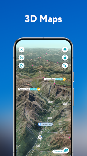

About this app
Developer Description
What's the name and the altitude of that mountain? Find out with PeakVisor!
Here’s a brief orientation on the tools we offer to get oriented in the mountains:
● 3D Maps
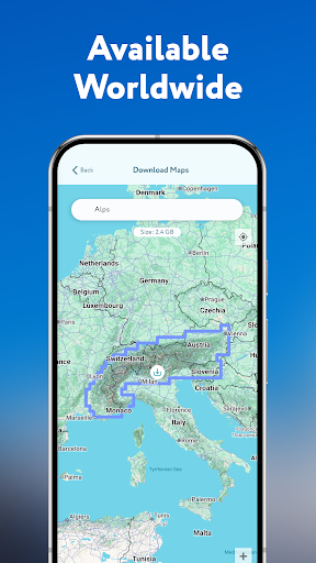
As human athletic achievement progresses in the mountains, so does the technology to assist your adventures. With PeakVisor, you unlock the topo maps of the future; our cutting-edge technology with high-precision terrain modeling offers deep insight into the mountain landscape of your choice. With one glance, you be blessed with years of knowledge about an area’s terrain.
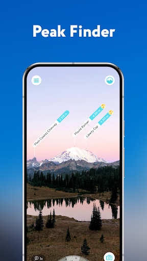
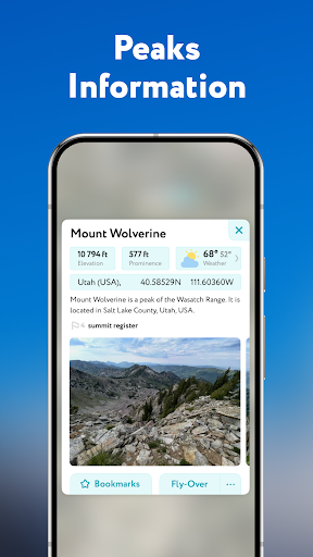
● Identify Peaks
Identify more than a million mountains, hills, buttes, spires, and more from all over the world, with a detailed profile for each of them! Our app shows you altitude, topographic prominence, mountain range, national parks or reserves, as well as photos and additional Wikipedia articles.
● Plan Hiking Routes
A vast network of worldwide hiking trails and walking pathways included in PeakVisor’s 3D Maps will help you compose a hiking route which includes evaluating the distance you can expect to hike as well as a route’s elevation profile and estimated time for completion.
● Skiing
In winter mountain sports, PeakVisor’s topographic 3D Maps allow a visual understanding of the terrain and provide detailed information about mountain lifts, ski resort trails, and backcountry ski touring routes. The app also offers features such as winter mode and a slope steepness overlay to identify avalanche terrain on your route.
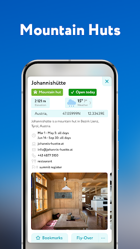
● Cable Cars and Mountain Huts are inlaid onto our 3D Maps, complete with schedules. This is especially useful in Europe, where many objectives involve a cable car ride to gain some altitude, lest you want to do some genuinely punishing climbs. And you haven’t experienced the old-world mountain culture until you’ve had a memorable meal and night at a rustic mountain hut in the high country.
● Peak Bagging
The app offers monthly climbing challenges and Peak Bagging competitions to keep the motivation where it needs to be…UP.
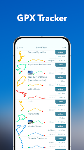
● GPS Tracking
Track any outdoor adventures, whether hiking, skiing, mountain biking, etc. Post-adventure, you can visualize your route in the miniature 3D world, check out stats like distance and elevation gain, and export a GPX file of your new route.
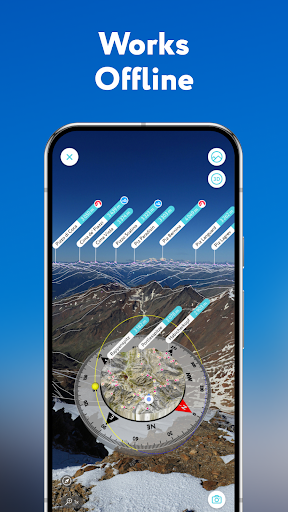
● All Features Work Offline
PeakVisor is the Swiss army knife for outdoor adventure, one that you will soon find indispensable while in the mountains. With so many features at your fingertips, you’ll find value from the app whenever you're on the trail.
What's New
In-app purchases
$11.99 - $184.99 per item
Version Information
- Version
- 2.9.63
- Downloads
- 50K+
- Updated on
- Dec 22, 2025
- Released
- Jun 14, 2017
- Requires
- Android 10
Statistics
Google Play Rating History
Rating Distribution
Downloads Over Time
PeakVisor - 3D Maps & Peaks ID has been downloaded times. Over the past 30 days, it averaged downloads per day.
Shaded area shows 30-day prediction based on historical trends
Historical data collection started recently. More data points will be available over time.
PeakVisor - 3D Maps & Peaks ID - Google Play Rankings
Top Rankings
| Rank | Country | Category | List | Change |
|---|---|---|---|---|
| — |
Ranking History in
No ranking data available yet. Rankings are updated daily.
#17 in Top Grossing Travel And Local in Italy


#32 in Top Grossing Travel And Local in Indonesia
 OsmAnd — Maps & GPS Offline
PeakVisor - 3D Maps & Peaks ID
OsmAnd — Maps & GPS Offline
PeakVisor - 3D Maps & Peaks ID
 GPS Navigation: Live Earth Map
#35 in Top Grossing Travel And Local in Brazil


#41 in Top Grossing Travel And Local in Turkey

PeakVisor - 3D Maps & Peaks ID users say on Google Play
 A Google user
The app force closes with the latest update. Unusable in its current for with Android Pie. Great app before aside from the compass, which never automatically aligned - always had to manually adjust it. Update: Developer fixed the app after becoming aware of the issue. Compass is currently tied to the magnetometer hardware of the phone.
 Andrei PETRACHE
Good features, not so good accuracy. About 80 - 90% details match. I set a peak manually and the neighbors don't match exactly. Works offline 👍🏻
 John Bramer
I've heard it's much better on the iPad but the interface for Android phones is very wonky. The tutorial is ineffective at teaching the basics of the app and the menus are confusing. If all you're looking for is peak naming, PeakFinder would be better. No useful route and trail info in the app even though they advertise it.
 CoronaViking. com
impossible to use app because of weird sensors problems in samsuns s20 phones. also i cannot disable the use of sensors and simply adjust 3d mesh manually.
 Matthew C. Shillings
I feel like I wasted my money on this app. The iPhone version is so much better. This feels like the annoying little brother that wants to do everything big brother does but just embarrasses it's self. It never knows which way it's pointing. You have to drag across the screen & hope you can line up the mountains. You also better have rock steady hands, one tiny move, and the whole outline freaks out and moves so that you are always fighting to keep it lined up. This feels like the wish version.
ApkTrusted Ratings & Reviews
Similar Apps

swisstopo
Free
PeakFinder
Paid

AlpineQuest Explorer Lite
Free

Outdooractive. Hike and Ride
Free

Gaia GPS: Offline Trail Maps
Free

HiiKER: The Offline Hiking app
Free

Guru Maps Pro & GPS Tracker
Free

Compass & Altimeter
Free

Skratch: Travel Map & eSIM
Free

bergfex: Hiking & Tracking
Free

Orca: Boat GPS, Charts, Routes
Free
OsmAnd — Maps & GPS Offline
Free

Avenza Maps: Offline Mapping
Free

Mapy.com: Offline hiking maps
Free

Navionics® Boating
Free

AllTrails: Hike, Bike & Run
Free
Scan this QR code to download

Forwarding you to the page at Google Play market in seconds...
Open Google Play market now