
Topographical charts Holland vVARY
Surfcheck


About this app
Developer Description
The best topographical, aerial photos and land registry maps for the Netherlands
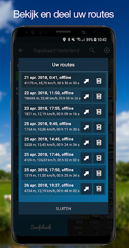
Please do mind: the app also contains an excellent and very stable GPS tracker - available as a pro feature - and features Open Street Map maps for all the countries outside the Netherlands. The interface language though, is in Dutch.
Disclaimer
We do our utmost to deliver you the best software and data available in the market, but of course we cannot guarantee the proper functioning or accuracy of both. Data sources can change over time. You can not derive rights from this information. By downloading and using this app you accept these terms.
Location
The location permission is necessary to enable the app to show you your current position. It is not used nor stored for anything else at all.
In-app purchases
$1.99 per item
Version Information
- Version
- -
- Downloads
- 10K+
- Updated on
- -
- Released
- Apr 28, 2018
- Requires
- Android Varies with device
Statistics
Google Play Rating History
Rating Distribution
Downloads Over Time
Topographical charts Holland has been downloaded times. Over the past 30 days, it averaged downloads per day.
Shaded area shows 30-day prediction based on historical trends
Historical data collection started recently. More data points will be available over time.
Topographical charts Holland users say on Google Play
 Naasir Abubakar
not work by other languages
 A Google user
No offline maps. Uninstall
ApkTrusted Ratings & Reviews
More from Surfcheck
See more apps
Ad Astra: Star Atlas
Free
Weather in Holland: the app
Free

Tidal Atlas North Sea, East
Paid

Tidal Atlas Irish Sea, Bristol
Paid
The Tides - the Netherlands
Free
Tidal Stream Atlas, Dover
Paid
Tidal Atlas North Sea, South
Paid

Tidal Atlas North Sea, NWest
Paid
Binnenvaartpolitiereglement
Paid
Het Weer: de weerapp
Free

Stroomatlas Noordzee
Paid
Het Weer: de weerapp
Free
Tidal stream atlas, English Ch
Paid

Tidal Stream Atlas France W.
Paid
Tidal Stream Atlas, Scotland
Paid

Tidal Stream Atlas, Thames Est
Paid
Scan this QR code to download

Forwarding you to the page at Google Play market in seconds...
Open Google Play market now