
Tidal Atlas Irish Sea, Bristol vVARY
Surfcheck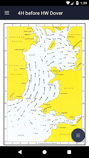


About this app
Developer Description
All sea charts from the Tidal Stream Atlas for the Irish Sea and Bristol Strait
This app is universally available on both your Smartphone and Tablet. The sea maps are zoomable, thus also of good use on the smaller phone screen.
This app is built and maintained by Surfcheck. All charts © Crown Copyright and/or database rights. Reproduced by permission of the Controller of Her Majesty’s Stationery Office and the UK Hydrographic Office (www.ukho.gov.uk).
Disclaimer:
We do our utmost to deliver you the best software and data available in the market, but of course we cannot guarantee the proper functioning or accuracy of both. Data sources can change over time. You can not derive rights from this information. By downloading and using this tidal stream atlas you accept these terms.
Version Information
- Version
- -
- Downloads
- 100+
- Updated on
- -
- Released
- Oct 1, 2017
- Requires
- Android Varies with device
Statistics
Google Play Rating History
Rating Distribution
Downloads Over Time
Tidal Atlas Irish Sea, Bristol has been downloaded times. Over the past 30 days, it averaged downloads per day.
Shaded area shows 30-day prediction based on historical trends
Historical data collection started recently. More data points will be available over time.
ApkTrusted Ratings & Reviews
More from Surfcheck
See more apps
Zeeweer - Maritieme app
Free

Weer Nu - Weerbericht en Radar
Free

Weather in Holland: the app
Free

Ad Astra: Star Atlas
Free

Tidal Stream Atlas France W.
Paid

Tidal Stream Atlas, Dover
Paid

Stroomatlas Noordzee
Paid

Tidal stream atlas, English Ch
Paid

The Tides - the Netherlands
Free

Tidal Stream Atlas, Scotland
Paid

Tidal Stream Atlas, Thames Est
Paid

Topographical charts Holland
Free
Water Map Live - Routes, AIS
Free

Het Weer: de weerapp
Free
Weerwaarschuwing: Weeralarm NL
Free

Binnenvaartpolitiereglement
Free
Similar Apps


Scan this QR code to download

Forwarding you to the page at Google Play market in seconds...
Open Google Play market now