
WindAlert: Wind & Weather Map v5.0
WeatherFlow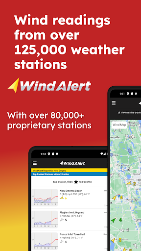


About this app
Developer Description
Wind & weather forecasts, windy conditions, with alerts, tides & radar map
Why you should download WindAlert:
- Neighborhood observations from proprietary Tempest Weather Systems along with all public domain weather reports (NOAA, NWS, METAR, ASOS, CWOP) including all major airports creating over 125,000 unique stations.
- Our exclusive Tempest Weather Systems with haptic rain sensors, sonic anemometers, along with local barometric pressure sensors yield reliable, ground truth observations.
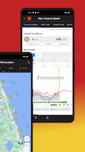
- Live wind from our systems provides a better windy conditions flow map – augmented by current station reports with advanced quality control.
- Proprietary AI-enhanced Nearcast forecasting supplies upgraded forecasting for temperature, wind gust, speed, direction, humidity, dewpoint, precipitation rate, probability of precipitation, and cloud cover percentage.
- Multiple public domain forecast models including High Resolution Rapid Refresh (HRRR), North American Mesoscale Forecast System (NAM), Global Forecast System (GFS), Canadian Meteorological Centre Model (CMC) and Icosahedral Non Hydrostatic Model (ICON).
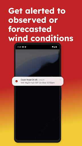
- Free subscription for unlimited wind notifications and alerts with customizable thresholds to email, text, or in-app.
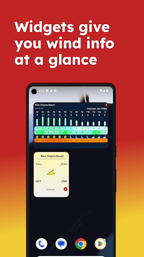
- Advanced location management: create your own favorite station list to keep a constant eye on your stations.
- Maps: Live and Forecasted Wind, Forecasted Temperature, Radar, Satellite, Precipitation and Clouds, as well as Nautical Charts.
- Customized maps support drone pilots, small aircraft, farming, running, dog walking, gardening, trucking, hauling, kayaking, surfing, you name it!
- National Weather Service (NWS) Marine Forecasts
- All the additional parameters you want:
- Tides charts
- Wave Height, Wave Period
- Water Temperature
- Sunrise / Sunset
- Moonrise / Moonset
- Historical Wind Speed
- Windy days per month based on average and gust
- Wind direction distribution
Want to get more weather?
- Upgrade to plus, pro, or gold membership to gain access to more weather stations and forecast locations.
- Pro and Gold members get access to Professional hurricane-proof stations in partnership with WeatherFlow Networks for high risk coastal locations.
- Detailed weather info, gusts, rain radar, satellite, NOAA, NWS, at spots of interest to coastal residents and property owners near the ocean, rivers, and other bodies of water.
- On the water features
- Sea surface temperatures
- Sea surface currents
- Detailed historical wind statistics
- Historical wind speed average by year
What else can you do?
- Join the Tempest Weather Network!
- Get a Tempest Weather System for your backyard.
- Your TempestHome Systems can be displayed in the WindAlert application.
- Share historical weather with the broader community and increase the science record.
Want more?
Get support at: help.tempest.earth/hc/en-us/categories/200419268-iKitesurf-iWindsurf-SailFlow-FishWeather-WindAlert
Connect with Tempest:
- facebook.com/tempestwx/
- twitter.com/tempest_wx
- youtube.com/@tempestwx
- instagram.com/tempest.earth/
Contact Tempest: help.tempest.earth/hc/en-us/requests/new
website: tempest.earth
What's New
In-app purchases
$5.49 - $179.99 per item
Version Information
- Version
- 5.0
- Downloads
- 100K+
- Updated on
- Jan 15, 2026
- Released
- Oct 15, 2010
- Requires
- Android 5.0
Statistics
Google Play Rating History
Rating Distribution
Downloads Over Time
WindAlert: Wind & Weather Map has been downloaded times. Over the past 30 days, it averaged downloads per day.
Shaded area shows 30-day prediction based on historical trends
Historical data collection started recently. More data points will be available over time.
WindAlert: Wind & Weather Map - Google Play Rankings
Top Rankings
| Rank | Country | Category | List | Change |
|---|---|---|---|---|
| — |
Ranking History in
No ranking data available yet. Rankings are updated daily.
#66 in Top Grossing Weather in Canada
WindAlert: Wind & Weather Map users say on Google Play
 Glenn Sikes
This is a very handy and highly accurate app for current and future wind speed and direction. Great for racers, cruisers and fishermen.
 DbdbDan B
Nice tool when used with other apps adding to my feel for conditions at launch. A few meter points seem pointing in wrong direction but i get there can be a swirl, turbulence etc. Overall, this helps with my feel
 MIke Price
like the app if you didn't have to pay for certain wind buoys
 Luke F
Weatherflow, what are you doing? I've been PAYING for this service for over 10 years. I happened to like the way the app worked for most of those years. I'm willing to over look the ads in my face despite the fact I'm a paying customer, but this new interface is garbage. Everything takes longer to load in spite of all the content remaining the same, some of the layout doesn't even fit on my phone's screen!
 Kyle Lee
Was great used for years for my crane to predict wind changes and was pretty accurate but now they want to charge 15$ a month for it when it was free. I used it because it was simple to use and free now that it's upgraded more complicated and cost 15$ I'll just use the weather channels app. This was a poor decision for the developers. I would have paid a yearly cost or a 1 time cost to remove ads but I'm not subscribing to something for the wind that's more expensive than streaming services
ApkTrusted Ratings & Reviews
More from WeatherFlow
See more apps


Similar Apps

Wavve Boating: Marine Boat GPS
Free
Windfinder Pro: Wind & Weather
Paid
St. Cloud Live StormTRACKER
Free

Emergency: Severe Weather App
Free
NOAA Weather Unofficial (Pro)
Paid

BassForecast: Fishing Forecast
Free

Weather data & microclimate :
Free

Deep Dive - Bass Fishing App
Free
Windfinder: Wind & Weather map
Free

FOX Weather: Daily Forecasts
Free

Nautide: Tides, Wind, Waves +
Free

MyRadar Weather Radar
Free

Weather & Radar USA - Pro
Paid
Rivercast - River Levels App
Free

Today Weather:Data by NOAA/NWS
Free

WeFish | Your Fishing Forecast
Free
Scan this QR code to download

Forwarding you to the page at Google Play market in seconds...
Open Google Play market now