
Hawk Map GPS-GIS vVARY
DakikTech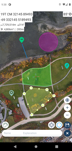


About this app
Developer Description
Tactical GPS app that includes GIS, measurement and planning tools
It is also a complete helper for airsoft, mountaineering, trekking and hiking, cross running, scouting, hunting, fishing, geocaching, off-road navigation and all other outdoor activities and sports.
With satellite navigation systems such as GPS, GALILEO and GLONASS (GNSS) supported by your device and your sensors, you can see your most accurate position on different map layers.
⭐⭐Features⭐⭐
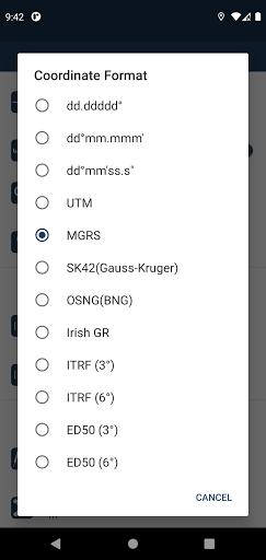
👉 Coordinate Indicator, finder and converter
Format options:
- D°M'S" (WGS84)
- Latitude/Longitude (WGS84)
- UTM (WGS84/NAD83),
- MGRS / U.S. National Grid (USNG) (WGS84/NAD83)
- SK42(Gauss Kruger)
- British National Grid(BNG-OSNG)
- Irish Grid Reference
- ED50 (6°-3°)
- ITRF (6°-3°)
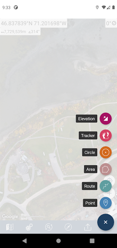
👉 You can make colored markings on the map.
Markers,Polygons,Polylines,Circles
👉 Area & Distance measurement
Distance unit options: m , ft , mi , yd , nmi
Area unit options: m² , ha , ft², yd², mi²
👉 Elevation information
👉 Compass
Angular unit options: Degrees ,NATO mil, Warsaw Mil, Grad
👉 Map style options: (Road,Terrain,Satellite,Night Mode,Hybrid)
👉 KML viewer. (Export and import KML layers).
👉 GPS track recorder.
Version Information
- Version
- -
- Downloads
- 100K+
- Updated on
- -
- Released
- Mar 9, 2021
- Requires
- Android Varies with device
Statistics
Google Play Rating History
Rating Distribution
Downloads Over Time
Hawk Map GPS-GIS has been downloaded times. Over the past 30 days, it averaged downloads per day.
Shaded area shows 30-day prediction based on historical trends
Historical data collection started recently. More data points will be available over time.
Hawk Map GPS-GIS users say on Google Play
 Jeff Ferguson
As an emergency communications volunteer with an ARES district in Washington State I've found Hawk Map very useful. Our digital comms formats include location with coordinates reported in Lat/Lon decimal degrees and MGRS. The ability to display both on the screen simultaneously facilitates more efficient communications for those we support. Thank you!
 L Jones
I'm using Galaxy S10 - I see the reviews about crashing, but so far it has not crashed for me, however, I have been unable to export/import. I click "export as", name it, click ok and "export as" box remains. The XML list remains empty and when I click the plus sign nothing happens. I am still learning the "convert and find" function. This is day one of use, I will keep checking it. *UPDATE I allowed storage permission and export/import is working.
 Will C
Is good, but instructions be handy. Bit of playing around to suss it out
 Jeremy Harrison
Ability to display location in two formats is useful. Good that it includes both OSNG and Irish Grid systems, but has problems for both (1) it drops leading zeros in co-ordinates: these are required to know whether SP 1 1 is SP 10000 10000 or SP 00001 00001 (as in MGRS); and (2) for 'out of area' locations (not in british isles) it gives wrong or nonsense locations.
 A Google user
Crashed almost immediately and caused my phone (Samsung a50) to restart. I really like the old version and use it all the time out in the bush. If the issues are sorted out this will likely be a great gps app as the older one was excellent for what it is. Looking forward to seeing this fixed and trying it again, until then I do not recommend this.
ApkTrusted Ratings & Reviews
More from DakikTech
See more apps


Similar Apps


Scan this QR code to download

Forwarding you to the page at Google Play market in seconds...
Open Google Play market now