MGRS UTM GPS v1.10.26
Y2 Tech


About this app
Developer Description
Offline GPS with MSL Altitude for Surveyors, Military & Orienteering.
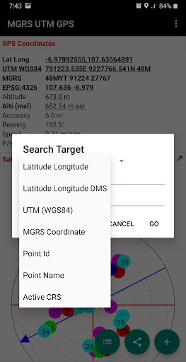
Additional information include GPS altitude (Ellipsoid), MSL altitude (EGM96), accuracy, speed, bearing and GPS Sky View complete with information about satellite name, satellite location (azimuth & elevation angle) etc..
Free Features:
- Getting GPS coordinates from most commonly used map projections / Coordinate Reference System in the World.
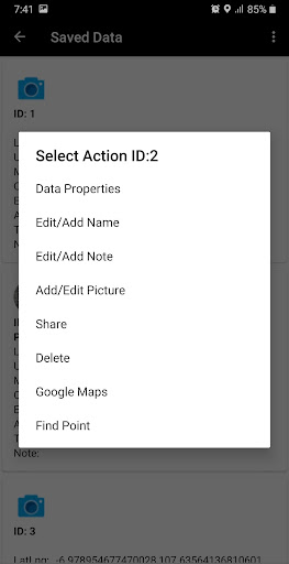
- Share or save unlimited measure data inside your database.
- Change altitude units (meter, feet).
- Change Latitude Longitude display format (decimal degrees, DMS)
- Change UTM display format (UTM with band letter, UTM with north/south hemisphere)
- Change speed units (m/sec, km/h, mi/h, knots)
- Add photo to your data.
- Labelling: edit notes / label on each observation data.
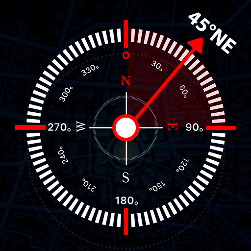
- Searching point / coordinate using compass.
- Export data to CSV, KML, GPX and DXF file.
- Calculate Area and Distance.
Premium Features:
- No Ads.
What's New
In-app purchases
$2.99 - $9.99 per item
Version Information
- Version
- 1.10.26
- Downloads
- 100K+
- Updated on
- Jul 25, 2025
- Released
- Dec 4, 2017
- Requires
- Android 6.0
Statistics
Google Play Rating History
Rating Distribution
Downloads Over Time
MGRS UTM GPS has been downloaded times. Over the past 30 days, it averaged downloads per day.
Shaded area shows 30-day prediction based on historical trends
Historical data collection started recently. More data points will be available over time.
MGRS UTM GPS users say on Google Play
 A Google user
Using this to record invasive plant species. I like the simultaneus lat-long utm displays. Easy to save and share even with the free version.
 alex bodnaru
it's a good application to share a geographic location by a variety of coordinate projections. it's good to have it when you're lost, and can share your location only over SMS but not over any internet app. the 5th star is missing, since the app menus are too dark, so they aren't visible in clear sun. i promise to give you the five stars when you fix it.
 Aondowase Edward Ayua
It is good tool for location and recce work in land Surveying, GIS and Cartographic work. However there is need to add the nevigational aspect of it to show direction in case one wants to locate property beacons that earlier had been coordinated
 Red
Red
Allows to change between time format (GMT, UTC) but does not display this data for use.. Need to be able to confirm Zulu times along with GPS. Please.
 Pascal Nayo
Accuracy not good and fails to detect compass
ApkTrusted Ratings & Reviews
More from Y2 Tech
See more apps

Similar Apps

Mergin Maps: QGIS in pocket
Free

GPS Essentials
Free

Footpath Route Planner
Free

Gaia GPS: Offline Trail Maps
Free

Bike Route Planner
Paid

My Emotional Compass
Paid

WhatsGPS
Free

Skratch: Travel Map & eSIM
Free

seca myAnalytics
Free
Qibla Direction- GPS Compass
Paid

DeRadar
Paid

Avenza Maps: Offline Mapping
Free

TRACX - The Event App
Free

ArcGIS Survey123
Free

Windmate
Paid

Südtirol Fishing
Free
Scan this QR code to download

Forwarding you to the page at Google Play market in seconds...
Open Google Play market now