
UTM Geo Map v4.3.03
Y2 Tech


About this app
Developer Description
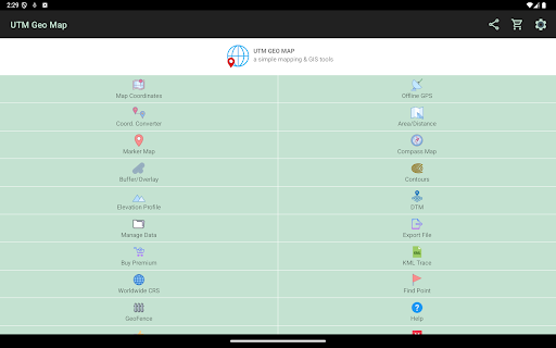
Simple Mapping & GIS Tools.
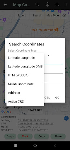
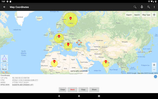
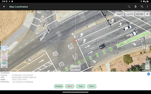
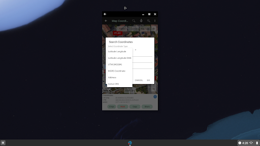
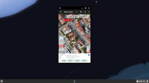
Map Coordinates: Can be used to obtain Latitude Longitude, UTM, MGRS (WGS84) & other CRS (using EPSG codes) in real time, register points complete with coordinate data, time taken, notes/labels, elevation (premium), addresses, photos etc. This module can also display TIN, Voronoi Diagrams and Buffers in realtime from existing points.
Offline GPS: Used to get coordinates in an offline state (without internet access), your cellphone will function like a Handheld GPS to get Latitude Longitude coordinates, UTM, MGRS, Elevation (ellipsoid), MSL Elevation (EGM96), accuracy, satellite and other useful information. Coordinates data can be stored in an unlimited number inside your databases, given notes / labels, photos or exported into CSV, KML, DXF & GPX formats.
Coord. Converter: To convert coordinates manually from Latitude Longitude to UTM & MGRS and vice versa. It can also be used to convert addresses to coordinates (Geocoding, requires an internet connection). Some conversion is support for batch conversion.
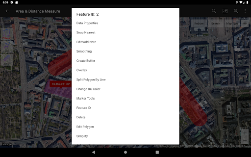
Area/Distance: Used to measure distance and area (support units: m, km, ft, miles, hectare, acre), register lines / polygons, make polygons automatically from measure points, create buffers from lines / polygons, overlay etc.. Line / polygon data can be stored in unlimited number inside your database, displayed on a map, added photos and labels or exported to CSV, KML or DXF format. Equipped with spatial editing algorithms such as Snap Nearest, Delete Object Inside / Outside Polygon, Smoothing (cubic bezier interpolation), Split Polygon By Line, and so on. Can read CSV & KML formats to import or display as reference files.
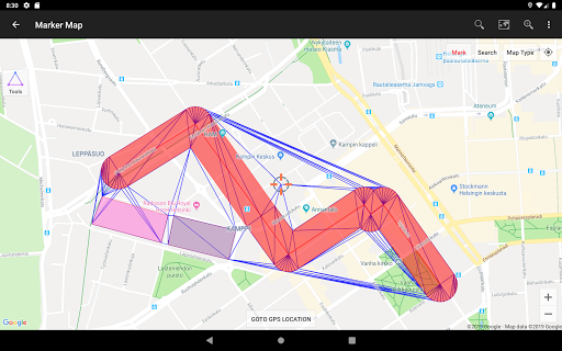
Marker Map: Similar to the Map Coordinates module but with more complete & complex geometry calculation such as displaying Dynamic / Variable Buffers. In this module geometric analysis such as TIN & Voronoi Diagrams can be made from a combination of point data (markers) as well as lines and polygons (breakline). These geometries can also be exported to KML or DXF files for use on other devices or PC.
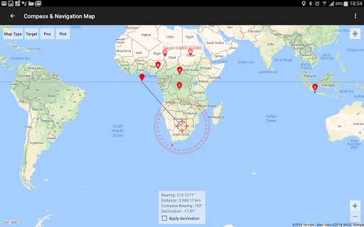
Compass Map: Module with a map and compass with magnetic declination, can be used to assist in navigating or measuring the azimuth angle and determining distance & direction.
Buffer/Overlay: Module to perform buffering & overlays (and other GIS operations) with several options including Union, Intersection, Difference and Symmetrical Difference.
Elevation Profile: Used to create simple elevation profiles (cross section / long section) from height data with metric & ft / mile units. This module can also create elevation profiles from multiple points including elevation profile from route (premium).
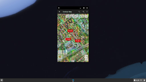
Contours: Module to generate contours based on number of contour lines, desired elevation or contour interval. This is premium module & need internet connection.
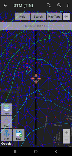
DTM: Digital Terrain Model, module to generate TIN / GRID surface & Contour Lines from elevation data. Calculate Cut And Fill volume, TIN refinement, Grid interpolation and dynamic Elevation Profile.
Some other modules.
Website: https://www.utmgeomap.com
Quick guide (pdf): https://www.utmgeomap.com/utmgeomapquickstart.pdf
YouTube: https://www.youtube.com/channel/UCspxQ5nQiqRD88g_-6GcCqw
Any suggestions are welcome, please submit via email to utmgeomapapp@gmail.com or write a review. Thanks.
What's New
In-app purchases
$0.99 - $13.99 per item
Version Information
- Version
- 4.3.03
- Downloads
- 1M+
- Updated on
- Jan 7, 2026
- Released
- Aug 8, 2017
- Requires
- Android 6.0
Statistics
Google Play Rating History
Rating Distribution
Downloads Over Time
UTM Geo Map has been downloaded times. Over the past 30 days, it averaged downloads per day.
Shaded area shows 30-day prediction based on historical trends
Historical data collection started recently. More data points will be available over time.
UTM Geo Map - Google Play Rankings
Top Rankings
| Rank | Country | Category | List | Change |
|---|---|---|---|---|
| — |
Ranking History in
No ranking data available yet. Rankings are updated daily.
#47 in Top Grossing Maps And Navigation in Pakistan


#50 in Top Grossing Maps And Navigation in Egypt

#50 in Top Grossing Maps And Navigation in Mexico

#54 in Top Grossing Maps And Navigation in Indonesia

UTM Geo Map users say on Google Play
 isr iissrr
could u add geotiff import to the app pls
 10 m
10 m
Overall, the app is good, but there are a few issues to address:1.Marked points are not exported to the CSV file. Please ensure that all marked locations are included during export. 2.Map tiles need to be re-downloaded. When zooming into a location and downloading the map, then navigating to other areas and returning, the previously downloaded map tiles must be downloaded again. 3.Add a geo-tracking system. A built-in geo tracker would be highly useful for monitoring movement, recording routes.
 Edwin Cruda
Can't read kml files
 Fazal Haq
but failed to install on my laptop but i failed to install it on my fone
 Thabo Moyo
keeps saying something went wrong
ApkTrusted Ratings & Reviews
More from Y2 Tech
See more apps

Similar Apps

Avenza Maps: Offline Mapping
Free

Mergin Maps: QGIS in pocket
Free

Gaia GPS: Offline Trail Maps
Free

Orca: Boat GPS, Charts, Routes
Free

Mapway: Maps & Transit Planner
Free

HiiKER: The Offline Hiking app
Free

GPS Essentials
Free

MAPS.ME: Offline maps GPS Nav
Free

Guru Maps Pro & GPS Tracker
Paid

Earth Map App - Live Cam View
Paid

OsmAnd — Maps & GPS Offline
Free

GPS Navigation Route Planner
Paid

ArcGIS Survey123
Free

Magic Earth Navigation & Maps
Free

Compass & Altimeter
Free

Footpath Route Planner
Free
Scan this QR code to download

Forwarding you to the page at Google Play market in seconds...
Open Google Play market now