E-walk - Hiking offline GPS v1.6.1
Tim Autin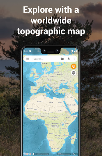
About this app
Developer Description
Find your next hike, record it, download offline maps, and more!
E-walk allows you to find your next outdoor activity, plan it, and record it. E-walk is the perfect companion for outdoors activities (such as hiking, trekking, biking, fishing, hunting, etc...) and for traveling abroad, because you can fully use it offline.
Lost in a forest? E-walk brings you back to your car. Forgot about where was this lovely boutique you noticed last year in Venice? E-walk refreshes your memory!
E-WALK KEY FEATURES
• worldwide high resolution topographic map (E-walk Topo Map), designed for hiking and outdoors activities
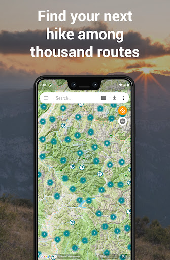
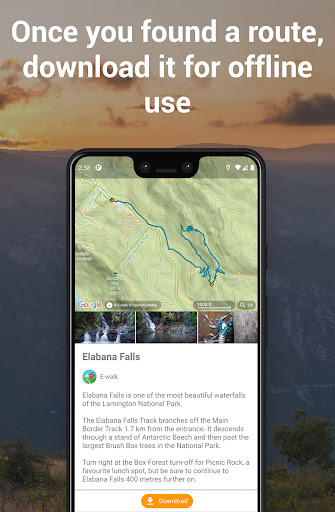
• find your next adventure among thousand routes, download them for offline use and share yours (requires a free E-walk account)
• full integration of IGNrando' (https://ignrando.fr): browse IGNrando' routes on the map, sync your IGNrando' content, upload routes to IGNrando' (requires a free IGNrando' account)
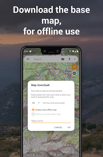
• download maps for later offline use (free for OpenStreetMap and Wikimedia Maps, with subscription for E-walk Topo Map)
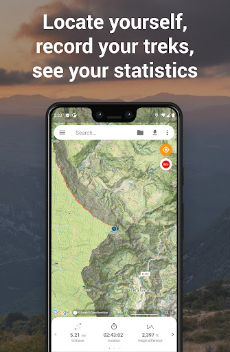
• show your current location on the map
• search places (last searches are saved for offline use)
• record your hikes
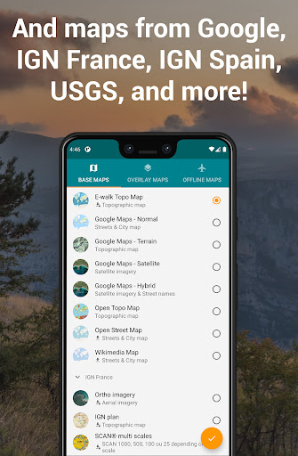
• select different base maps (streets, satellite, terrain, etc...)
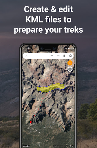
• plan your hikes by creating and editing KML files on the map. A KML file can contains markers, lines & polygons
E-WALK ADVANCED FEATURES
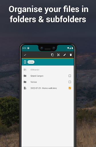
• organize your hikes in folders & subfolders
• display overlay maps (weather, roads, metro/bus, ski slopes, sea map, etc...)
• share your position via e-mail or SMS
• open a position in your other geo apps (such as Google Maps, Waze, TomTom, Sygic, Locus, Orux, MyTrails, etc...)
• share a hike by e-mail, bluetooth, etc... Either in KML file format (by default) or in GPX file format
• import GPX files (they will be converted in KMZ format)
• add custom maps in the XYZ protocol (see http://wiki.openstreetmap.org/wiki/Slippy_map_tilenames)
• add custom maps in the WMS protocol
E-WALK PLUS
E-walk has already a lot of features for free. But you can buy E-walk Plus to add the following:
• remove the ads
• have a scale on the map
• store your data on your SD card
• save / restore your data
• support E-walk's development
E-WALK MAX
E-walk Max unlocks all features of the app (excluding IGN Maps plugin). You can try it for free during 3 days. It includes all the advantages of E-walk Plus, and the following:
• download E-walk Topo Map for offline use
• pause your hikes recordings
IGN MAPS PLUGIN
The IGN maps plugin (https://play.google.com/store/apps/details?id=com.at.ewalk.plugin.ign) adds maps provided by the french national institute of geographical and forestry information (http://www.ign.fr).
CONTACT
A problem with E-walk? A suggestion? A feedback? Please do not hesitate to send an e-mail to contact@ewalk.app!
What's New
In-app purchases
$4.99 - $29.99 per item
Version Information
- Version
- 1.6.1
- Downloads
- 100K+
- Updated on
- Dec 7, 2025
- Released
- Jul 29, 2015
- Requires
- Android 5.0
Statistics
Google Play Rating History
Rating Distribution
Downloads Over Time
E-walk - Hiking offline GPS has been downloaded times. Over the past 30 days, it averaged downloads per day.
Shaded area shows 30-day prediction based on historical trends
Historical data collection started recently. More data points will be available over time.
E-walk - Hiking offline GPS users say on Google Play
 A Google user
Excellent hiking app. Very impressed by its capabilities. Easy to use interface, maps are easy to download. Have used E-walk in very remote areas and has tracked new routes and followed existing gpx imports with no issues - all perfectly in offline mode. I did have an issue with gps dropping but thanks to the devs response and solution this edited review reflects as such. Thank you so much!
A Google user
Had used the free version and found it worthy of paying for the full version. Very useful to have detailed off-line maps for your walks. Couple of requests - could you somehow show on a zoomed out map the areas you already have downloaded? Drawing a trek in advance is not easy on the app, I end up just putting in a number of pushpins to aim for. Could the app (using the phone's compass) then show you the right direction to the next waypoint/pushpin?
 David Whittle
Tried the subscription map and looks nice but didn't have some detail that I get in some other free ones , I live in a remote area and some of the remote cottages and farms were missing although what information that was there was clear
 Karsten Keese
One can only purchase "no ads", but everything worthwhile is still only available by means of additional subscriptions, via an idiotic configuration of requiring an additional plug-in to obtain maps and such, for which customers are then bled dry ad infinitum with recurring subscription fees. There are superior competitor products in the Play Store that can be bought instead of rented, which is why this milkingware has been replaced with a better alternative and is therefore being uninstalled.
A Google user
I had thought, that it was Fine, Yet whilst on a Three Day Trial Period..... The App Or Sevice started to Suck! The Two & a Half Hours to a Useable WiFi Service, trying to CANCELL, the E-walk Folks had Charged Me...? It Sucks, but I am Stuck with This for a Year! I HAVE To Use It!?! Damn It!!!
ApkTrusted Ratings & Reviews
Similar Apps

FarOut
Free

Südtirol Fishing
Free

Bike Route Planner
Paid

Road to Hana Maui Audio Tours
Free

National Park Service
Free

Trippy Tour Guide
Free
Hikingbook: Hike, Bike & Run
Free

Shaka Guide | GPS Audio Tours
Free
Qibla Direction- GPS Compass
Paid

Big Island Audio Tour Guide
Free

Footpath Route Planner
Free

Honge.ai - AI Travel Planner
Paid

Clubworx
Free

TrailLink: Bike, Run, Walk
Free

Contours: Ski Snowboard Tour
Free

Revealed Travel Guides
Free
Scan this QR code to download

Forwarding you to the page at Google Play market in seconds...
Open Google Play market now