
OpenRunner : bike & hike maps v2.9.2
Openrunner


About this app
Developer Description
Topographic maps, offline mode, route creation and tracking
Whether you're passionate about cycling, mountain biking, trail running, hiking, horse riding, or even skiing, OpenRunner is the essential app for creating and exploring new routes. So, shall we plot together?
- Plot a route. Directly from your smartphone, you can easily, in just a few clicks, plot a route according to the activity chosen (running, trail running, hiking, cycling, mountain biking, Gravel…) that matches your current desires and abilities thanks to the real-time display of distance and elevation gain, mountain passes to cross, estimated time...
- Search for a route. Out of inspiration? Search and find the route that suits you among several million routes shared by the OpenRunner community! Filter by locality, distance, elevation gain, or activity to find the outdoor experience that suits you.
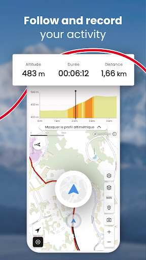
- Follow, record, share. OpenRunner gives you the ability to track your progress from your smartphone or your GPS device (watch, counter), whether you are following a trace or not, as well as to record your activity. Add photos, points of interest, comment, and share your route if you wish with other community members.
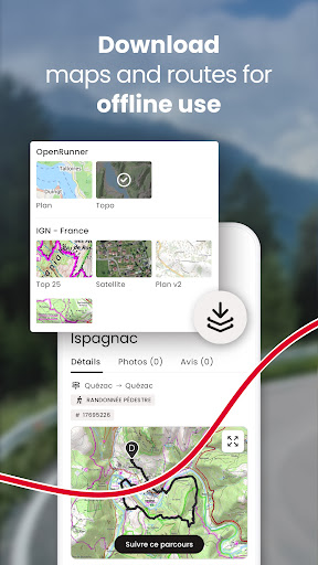
- Offline mode. When the network lets you down, OpenRunner does not, wherever you are! You can download maps for an offline use of the application.
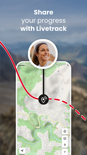
- Safety first. With the LiveTrack feature, you will be tracked to the letter! LiveTrack is about reassuring and being reassured, setting out with peace of mind, safely, without worrying your friends and relatives... LiveTrack indeed allows them to follow your progress in real time on a map and to remotely check your position, speed, and altitude.
With EXPLORER, take it to the next level! Our subscription gives access to many features(*) that make route creation easier and enrich your experience. It's simple, everything becomes possible. You won't be able to do without it!
- Specialized and precise mapping worldwide: IGN France maps with 3 backgrounds available (Top 25, Scan 25 Tour and Plan v2), IGN Belgium, IGN Spain, Luxembourg, Norway, Sweden, Finland, SwissTopo...
- Unlimited map downloads by area or along a route for offline use.
- Route creation without distance or number of waypoints restrictions.
- Organizing routes into unlimited and customizable lists.
(*) Other features are available on the computer like Google Street View, adding POIs (points of interest), full-screen mode, setting a new starting point, multi-route display...
And if quality is present on OpenRunner, it's mostly thanks to all the user feedback! So for any questions, suggestions, or improvements, write to us at: app@openrunner.zendesk.com
What's New
In-app purchases
$2.49 - $38.99 per item
Version Information
- Version
- 2.9.2
- Downloads
- 500K+
- Updated on
- Jan 5, 2026
- Released
- Nov 23, 2017
- Requires
- Android 6.0
Statistics
Google Play Rating History
Rating Distribution
Downloads Over Time
OpenRunner : bike & hike maps has been downloaded times. Over the past 30 days, it averaged downloads per day.
Shaded area shows 30-day prediction based on historical trends
Historical data collection started recently. More data points will be available over time.
OpenRunner : bike & hike maps users say on Google Play
 Patrick Malmartel
I spent 3 hours downloading maps for offline use. After that the app crashed and would crash everytime I restarted it. Had to re-install and obviously I had lost all the downloads. A similar problem happened before but I gave it a second chance. This app is not reliable which is an important criteria for people who hike and cycle.
 A Google user
Testing in progress. Seems easy to use. A good tool linked with its website
 Pedro
Pedro
Random Files that I have on my mobile are opened by default by this application. This is annoying
A Google user
"Download area too large for your subscription.". Really? Then it is useless. What did the developer expect from its users, to use it for a walk just around the block? It falls really short in almost every aspect.
 Alexander Clement (Alex23)
What on Earth is going on after the latest update? I cannot save my GPX route to my files or share them on WhatsApp etc. After having completed my route. I used to be able to download the GPX route i took easily but now it's only giving the option to just create the route on OpenRunner? Or.. Reddit?? What? Please help. Thank you
ApkTrusted Ratings & Reviews
Similar Apps

On Piste
Free

Kiprun Pacer Running Plans
Free

FarOut
Free
eBike Flow
Free

Outdooractive. Hike and Ride
Free

Decathlon Coach - fitness, run
Free

Polarsteps
Free
Ride with GPS: Bike Navigation
Free

Footpath Route Planner
Free
Trailforks
Free

Südtirol Fishing
Free

buycycle: buy & sell bikes
Free

bergfex: Hiking & Tracking
Free

HiiKER: The Offline Hiking app
Free

TrainerRoad
Free

Cyclers: Bike Navigation & Map
Free
Scan this QR code to download

Forwarding you to the page at Google Play market in seconds...
Open Google Play market now