
alpenvereinaktiv vVARY
Outdooractive AG


About this app
The alpenvereinaktiv app effectively solves the problem of planning and navigating mountain tours, both in summer and winter, by providing a comprehensive planning tool. This app benefits outdoor enthusiasts and adventure seekers who require detailed maps and navigation aids for safe and enjoyable experiences. Compared to other Maps and Navigation apps, alpenvereinaktiv stands out with its focus on mountain tours, though it may fall short in terms of broader geographical coverage. Its high user rating and moderate download numbers indicate a well-received and reliable application.
Pros
- With over 500,000 downloads and a very good user rating of 4.3 out of 5, this app demonstrates strong social proof and reliability.
- The app's free download with optional in-app purchases offers flexibility in accessing premium features, making it accessible to a wide range of users.
- The absence of required permissions is a significant advantage, indicating that the app does not collect unnecessary user data, thereby enhancing user privacy.
- The developer's reputation and the app's update frequency suggest a commitment to maintaining and improving the app, ensuring users have the latest features and fixes.
- Its offline capability, assuming it is available given the nature of the app, would be a significant advantage for users in areas with limited internet connectivity.
Cons
- The presence of ads could be seen as a drawback, potentially disrupting the user experience, especially during critical moments of planning or navigation.
- The range of in-app purchases, from $0.99 to $74.99, may deter some users, especially if the cost of unlocking full functionality is perceived as too high.
- The app's limited geographical focus on mountain tours might not appeal to users seeking a more general-purpose navigation app.
- User complaints or feedback regarding the app's performance, particularly concerning battery life or data usage, could be a concern for some potential users.
Best for: The ideal user for the alpenvereinaktiv app is an outdoor enthusiast, likely between the ages of 25 and 50, with a moderate to high level of technical skill, who regularly engages in mountain tours and seeks a reliable, feature-rich planning and navigation tool to enhance their safety and enjoyment of these activities.
Developer Description
Planning tool for mountain tours - summer and winter
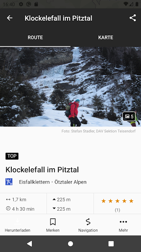
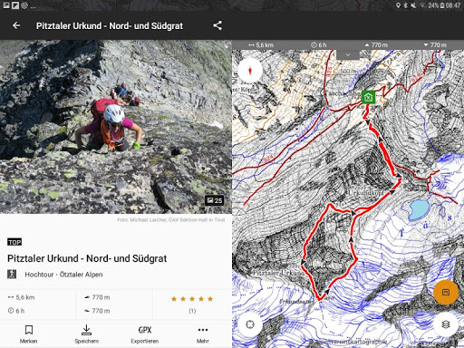
Whether for hikes, mountain, climbing or ski tours, with the alpenvereinaktiv tour portal you can find suitable tour descriptions, hut information, reports on current tour conditions as well as weather and avalanche information. In addition, all those who prefer to explore new paths can use the tour planner to achieve their individual tour destination.
Find tours worldwide
In the alpenvereinaktiv online portal and in the app you can find high-quality tour descriptions for almost all mountain sports activities worldwide.
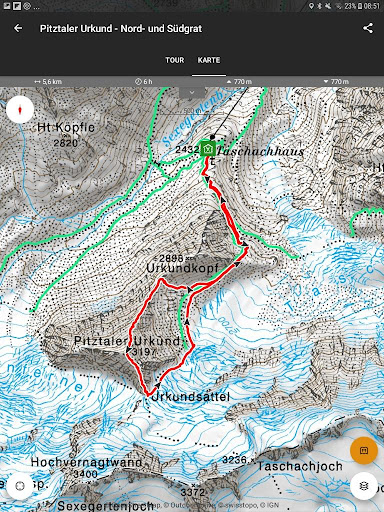
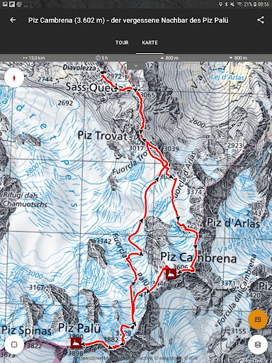
Plan your own tours worldwide
Whether in Patagonia, the Lofoten or the Alps, you can use the tour planner to plan your own individual tours.
Further information about tour planning
Current data on our Alpine club huts, avalanche reports, current tour conditions, slope slope layers for winter tours, information on closed areas and quiet zones as well as comments from users help with tour planning.
Worldwide offline storage
As a Pro/Pro+ user, you can save all existing maps and additional layers (slope steepness and path networks), your own tour planning and tour descriptions found with GPS track as well as hut data for offline use on your smartphone.
Record your own tracks
Would you like to record your own tours including duration, distance, altitude and altitude profile and at the same time use all the app's functions undisturbed? No problem at all! Exporting as a GPX file is then quick and easy.
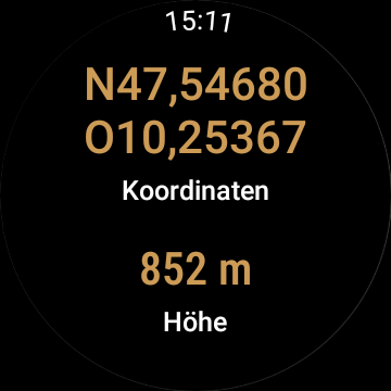
Smartwatches with WEAR OS by Google:
By looking at your smartwatch you get information about your position on the GPS map. You can record routes, read your tracking data and switch between different map types.
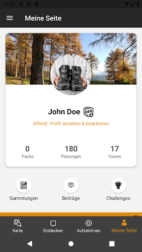
Easy synchronization
The alpenvereinaktiv app and the online tour portal are inextricably linked. If you are logged in as a user, tour planning moves from the PC directly to the smartphone and track recordings from the smartphone go back to the PC. This means that the strengths of both systems can be ideally combined with each other.
Navigation
Navigation function with voice output for all tours
BuddyBeacon
Safety first: Share your real-time location with friends and family.
Exclusively for Pro members
With Outdooractive Pro, maps and tours can be saved offline in the app, unlimited lists can be created and the app can be used ad-free. You will also receive a satellite map, the unique Outdooractive map with over 30 activity trail networks and the official topo maps of many countries around the world.
Exclusively for Pro+ members
Pro+ also contains the official maps of the Alpine Clubs as well as premium maps from KOMPASS and certified premium tours from KOMPASS, Schall Verlag and Topoguide Verlag.
The complete product range of Pro and Pro+:
www.alpenvereinaktiv.com/de/pro.html
www.alpenvereinaktiv.com/de/pro.html
Help and instructions can be found here:
https://alpenvereinaktiv.atlassian.net/servicedesk/customer/portals
If you have any problems, bugs or suggestions, you can reach us via the email address support@alpenvereinaktiv.com
Privacy
Given that the app requires no permissions, it appears to prioritize user privacy, minimizing the collection of personal data. However, users should still be cautious with in-app purchases and review the terms of service to understand what data, if any, is collected by the developer. Regularly reviewing the app's permissions and privacy policy is advisable to ensure ongoing privacy and security.
Tips
To get the most out of this app, first-time users should thoroughly explore the planning features to understand the full range of functionalities available. Setting up offline access, if available, before heading into areas with poor internet connectivity is crucial. Additionally, users should monitor the app's impact on battery life and data usage to optimize performance.
What's New
In-app purchases
$0.99 - $74.99 per item
Version Information
- Version
- -
- Downloads
- 500K+
- Updated on
- Dec 18, 2025
- Released
- Dec 3, 2018
- Requires
- Android Varies with device
Statistics
Google Play Rating History
Rating Distribution
Downloads Over Time
alpenvereinaktiv has been downloaded times. Over the past 30 days, it averaged downloads per day.
Shaded area shows 30-day prediction based on historical trends
Historical data collection started recently. More data points will be available over time.
alpenvereinaktiv - Google Play Rankings
Top Rankings
| Rank | Country | Category | List | Change |
|---|---|---|---|---|
| — |
Ranking History in
No ranking data available yet. Rankings are updated daily.
#10 in Top Grossing Maps And Navigation in Germany


#21 in Top Grossing Maps And Navigation in Italy

alpenvereinaktiv users say on Google Play
 Anja Böhm
great app: easy handling, very precise & fast localisation via GPS, good synchronisation with web app.
 A Google user
Was a very good application, but 30 euros a year for offline maps is too much...
 Daniel Kofler
Get logged off randomly, which is really bad if you cannot access your downloaded maps in areas without reception. Additionally the app is not intuitive at all. A map search of a tour only includes the tour if the startingpoint is in the map as well. Does not really make sense to me. I enjoyed the old version a lot more
A Google user
Für die reine Einblendung der Hangneigungen, die ja vor allem im Winter hilfreich sind, 30,- €/Jahr zu verlangen ist unangemessen. Schade, dass hier versucht wird mit kleinen, aber halt entscheidenden Details so Kasse zu machen.
A Google user
Seriously? I can understand charging for some of the more advanced features; but charging for a a basic feature like downloading offline maps is pretty asinine, especially when this project is supported by public funds and my membership dues from the DAV!
ApkTrusted Ratings & Reviews
More from Outdooractive AG
See more apps
Outdooractive. Hike and Ride
Free

Outdooractive Audio Guide
Free

Ain outdoor
Free

Swabian Alb Association
Free
Alpe Adria Trail
Free

Anii Drumetiei
Free

Amazon of Europe Bike Trail
Free

Rail & Trail
Free

Edersee | Deine Region!
Free

E-MOB: e-MTB at Trás-os-Montes
Free

Explore Falkland Islands
Free

Val Gardena-Gröden Outdoor
Free

Visit Herefordshire
Free

Thüringer Hofläden entdecken
Free

Erlebnis Nationalpark
Free

Hydra Trails - Hiking Guide
Free
Similar Apps


Scan this QR code to download

Forwarding you to the page at Google Play market in seconds...
Open Google Play market now